
Pricing Change
New pricing for orders of material from this site will come into place shortly. Charges for supply of digital images, digitisation on demand, prints and licensing will be altered.
Upcoming Maintenance
Please be advised that this website will undergo scheduled maintenance on the following dates:
Thursday, 9 January: 11:00 AM - 3:00 PM
Thursday, 23 January: 11:00 AM - 3:00 PM
Thursday, 30 January: 11:00 AM - 3:00 PM
During these times, some functionality such as image purchasing may be temporarily unavailable. We apologise for any inconvenience this may cause.
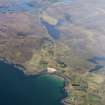
Badachro, General


Township (Period Unassigned)
Site Name Badachro, General
Classification Township (Period Unassigned)
Canmore ID 104952
Site Number NG77SE 26
NGR NG 7800 7367
NGR Description Centred NG 781 736
Datum OSGB36 - NGR
Permalink http://canmore.org.uk/site/104952


- Council Highland
- Parish Gairloch
- Former Region Highland
- Former District Ross And Cromarty
- Former County Ross And Cromarty
NG77SE 26 centred 781 736
'A collection of small crofts around the W shore of Caolas Bad a' Chrotha...'
Name Book 1881
A crofting township comprising twenty-five roofed, one partially roofed and two unroofed buildings is depicted on the 1st edition of the OS 6-inch map (Ross-shire 1881, sheet lvi). Thirty-eight roofed and four unroofed buildings are shown on the current edition of the OS 1:10560 map (1968).
Information from RCAHMS (SAH), 25 April 1996.
Field Walking (1 June 2008 - 2 June 2008)
NG 780 736 to NG 802 727 Work was undertaken, 1–2 June 2008, to identify any archaeology likely to be affected by the construction of a new water main at Shieldaig and Badachro. 13 sites were identified of which 7 were previously unrecorded. These included two hut circles, as well as post-medieval settlement, dykes, a trackway, and bridge footings.
Archive: RCAHMS (intended). Digital Archive: Highland HER
Funder: Halcrow Group Ltd
John Wood (Highland Archaeology Services Ltd), 2008

