
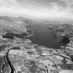
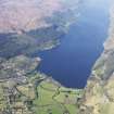
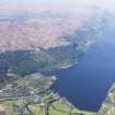
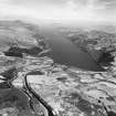
Caledonian Canal, Fort Augustus, South Pier


Pier (Period Unassigned)
Site Name Caledonian Canal, Fort Augustus, South Pier
Classification Pier (Period Unassigned)
Canmore ID 104371
Site Number NH30NE 37
NGR NH 38316 09266
NGR Description NH 38316 09266 to NH c. 38288 09294
Datum OSGB36 - NGR
Permalink http://canmore.org.uk/site/104371


- Council Highland
- Parish Boleskine And Abertarff
- Former Region Highland
- Former District Inverness
- Former County Inverness-shire

