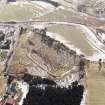
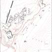
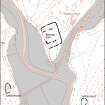
Accessibility

Font Size

100% 150% 200%

Background Colour

Default Contrast
Close Reset

Raeburnfoot

Farmhouse (Period Unassigned), Farmstead (Period Unassigned)

Site Name Raeburnfoot

Classification Farmhouse (Period Unassigned), Farmstead (Period Unassigned)

Canmore ID 104258

Site Number NY29NE 79

NGR NY 2527 9918

Datum OSGB36 - NGR

Permalink http://canmore.org.uk/site/104258

Ordnance Survey licence number AC0000807262. All rights reserved.
Canmore Disclaimer. © Bluesky International Limited 2025. Public Sector Viewing Terms

Toggle Aerial | View on large map

Digital Images

Raeburnfoot, oblique aerial view, taken from the NE, centred on the Roman Fort. Raeburnfoot farmsteading is visible in the bottom left-hand corner of the photograph and Craighaugh settlement and platform-building is shown in the top right-hand corner.
Raeburnfoot, oblique aerial view, taken from the NE, centred on the Roman Fort. Raeburnfoot farmsteading is visible in the bottom left-hand corner of the photograph and Craighaugh settlement and platform-building is shown in the top right-hand corner.Map of archaeological features in the landscape around Raeburnfoot. Published in Eastern Dumfriesshire: an archaeological landscape.Map of archaeological features in the landscape around Raeburnfoot. Published in Eastern Dumfriesshire: an archaeological landscape.

Administrative Areas

  • Council Dumfries And Galloway
  • Parish Eskdalemuir
  • Former Region Dumfries And Galloway
  • Former District Annandale And Eskdale
  • Former County Dumfries-shire

References

MyCanmore Image Contributions


Contribute an Image

MyCanmore Text Contributions