
Pricing Change
New pricing for orders of material from this site will come into place shortly. Charges for supply of digital images, digitisation on demand, prints and licensing will be altered.
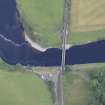
Dalguise, Tay Viaduct


Railway Viaduct (19th Century)
Site Name Dalguise, Tay Viaduct
Classification Railway Viaduct (19th Century)
Alternative Name(s) Tay Bridge; River Tay; Dalguise Viaduct; Dalguise Bridge
Canmore ID 103505
Site Number NN94NE 13
NGR NN 99497 47943
Datum OSGB36 - NGR
Permalink http://canmore.org.uk/site/103505


- Council Perth And Kinross
- Parish Little Dunkeld
- Former Region Tayside
- Former District Perth And Kinross
- Former County Perthshire
NN94NE 13 99497 47943
Location previously cited as NN 9948 4791 to NN 9953 4803.
NMRS REFERENCE:
Engineer: Joseph Mitchell, 1861-2.
(Undated) information in NMRS.
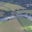
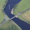
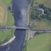
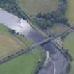
(Location cited as NN 994 480). Dalguise Viaduct, opened 1863 by the Inverness and Perth Junction Rly, engineer Joseph Mitchell. It is a monumental structure with two wrought-iron lattice-girder spans of 210 ft (64m) and 141 ft (42.9m) respectively supported on a masonry pier and abutments which are carried up to form castellated terminals.
J R Hume 1977.
This viaduct was designed by Joseph Mitchell to carry the Inverness and Perth Junction Rly across the River Tay and opened on 9 September 1863 at a cost of £20,395; it remains in use. It is of lattice girder type with stone piers and abutments and measures 516 ft (157.3m) in overall length and 67 ft (20.4m) in height; it comprises two spans of 210 ft (64m) and 141 ft (42.9m) respectively.
M Smith 1994.
This viaduct carries the Perth-Inverness main line of the former Highland Rly over the River Tay to the NE of Dalguise village (NN94NE 31). The river here forms the boundary between the parishes of Little Dunkeld (to the SW) and Dunkeld and Dowally (to the NE). It remains in regular use by passenger traffic.
This viaduct is depicted, but no noted, on the 1977 edition of the OS 1:10,000 map. The available map evidence indicates that it extends from NN c. 99476 47895 to NN c. 99538 48028.
Information from RCAHMS (RJCM), 13 June 1996.
Construction (1863)
One of a series of structures built by Highland Railway in Perthshire, early 1860s.
R Paxton and J Shipway 2007.
Project (2007)
This project was undertaken to input site information listed in 'Civil engineering heritage: Scotland - Lowlands and Borders' by R Paxton and J Shipway, 2007.
Publication Account (2007)
At Dalguise, about six miles north of Dunkeld, the former Highland Railway crosses the Tay on its original viaduct with two iron girder spans of 210 ft and 141 ft respectively, 16 ft deep and 67 ft above the bed of the river. The abutment and pier supports have ornamental castellated towers in masonry abutting the ends of the girders, almost certainlya legacy of Thomas Telford’s influence on Jospeh Mitchell’s practice. In recent years additional diagonal bracing has been added to the top chords of the trusses to improve lateral stability.
The girders are a development in wrought-iron of the earlier American timber lattice trusses of Ithiel Town
patented in 1820. The ironwork was manufactured and erected by Fairbairn Engineering Co., Manchester. The
contractors were Gowans & McKay.
A fascinating difference between Dalguise Viaduct and the Tummel and Logierait viaducts is that instead of castellated masonry towers the latter two were provided with sets of iron towers reminiscent of locomotive funnels. This use of iron was probably an economy measure on the Aberfeldy Branch which operated, none too successfully in commercial terms, for a century, being closed in 1965.
R Paxton and J Shipway
Reproduced from 'Civil Engineering heritage: Scotland - Lowlands and Borders' with kind permission of Thomas Telford Publishers.

