
Scheduled Maintenance
Please be advised that this website will undergo scheduled maintenance on the following dates: •
Tuesday 3rd December 11:00-15:00
During these times, some services may be temporarily unavailable. We apologise for any inconvenience this may cause.
Comrie


Enclosure (Period Unassigned), Lade (Period Unassigned), Mill Dam (Period Unassigned), Sheepfold (Period Unassigned), Township (Period Unassigned), Track (Period Unassigned)
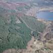
Site Name Comrie
Classification Enclosure (Period Unassigned), Lade (Period Unassigned), Mill Dam (Period Unassigned), Sheepfold (Period Unassigned), Township (Period Unassigned), Track (Period Unassigned)
Canmore ID 103377
Site Number NH45NW 18
NGR NH 4140 5595
Datum OSGB36 - NGR
Permalink http://canmore.org.uk/site/103377


- Council Highland
- Parish Contin
- Former Region Highland
- Former District Ross And Cromarty
- Former County Ross And Cromarty
NH45NW 18 4140 5595
A township comprising nine roofed buildings, one partially roofed building, one unroofed structure and three enclosures, and a sheepfold are depicted on the 1st edition of the OS 6-inch map (Ross-shire 1881, sheet lxxxvii). Three roofed buildings, two enclosures and the sheepfold are shown on the current edition of the OS 1:10000 map (1992).
Information from RCAHMS (AKK) 7 March 1996.
Srp Note (10 January 2011)
These sites are centred on NH 4139 5593 on the N side of the River Meig. The original township of Comrie was probably located to the W of the courtyard farm complex depicted on 1st edition of the OS 6-inch map (Ross-shire 1881, sheet lxxxvii). Two potentially earlier buildings (013 & 014) and a possible lime or corn kiln (019) have been identified around the periphery of the modern farm. Few of the buildings depicted on the 1st edition of the OS map survive although the sheepfold (015) has been largely retained.
Other features included in this record include a mill pond (018) and lade (017) which are also depicted on the 1st edition of the OS map.
Further details of these and other associated sites can be found in the Strathconon Phase 1 Report (pages 15-16) produced by the North of Scotland Archaeology Society and appended to this record.

