
Pricing Change
New pricing for orders of material from this site will come into place shortly. Charges for supply of digital images, digitisation on demand, prints and licensing will be altered.
Scheduled Maintenance Notice
Please be advised that this website will undergo scheduled maintenance starting on Thursday, 30th January at 11:00 AM and will last until Friday, 31st January at 10:00 AM.
During this time, the site and certain functions may be partially or fully unavailable. We apologise for any inconvenience this may cause.
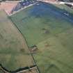
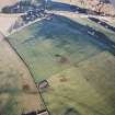
Rothiemay, Deveron Railway Bridges


Railway Bridge(S) (20th Century)
Site Name Rothiemay, Deveron Railway Bridges
Classification Railway Bridge(S) (20th Century)
Alternative Name(s) River Deveron; Deveron Viaduct
Canmore ID 103342
Site Number NJ54NW 38
NGR NJ 53451 45846
NGR Description NJ 5339 4583 to 5349 4579, 5339 4592 to 5347 4584
Datum OSGB36 - NGR
Permalink http://canmore.org.uk/site/103342


- Council Aberdeenshire
- Parish Huntly
- Former Region Grampian
- Former District Gordon
- Former County Aberdeenshire
NJ54NW 38 53451 45846
Between 1880 and 1900 this line was converted to double-track between Dyce and Keith, a new bridge being built alongside the old one. This later structure comprised two lattice girder spans, each of which measured 212 ft 6 ins (64.8m) in length and 25 ft (7.6m) in breadth. The original bridge was not demolished until 1978. The new bridge was reduced to single track in 1970 but remains in use.
M Smith 1994.
These bridges carry (new, west, bridge) or have carried (old, east, bridge) the Aberdeen-Inverness (main) line of the former Great North of Scotland Rly. across the River Deveron, which here forms the boundary between the parishes of Huntly and Cairnie, both in Aberdeenshire.
Information from RCAHMS (RJCM), 11 June 1996.

