
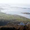
North Uist, Port Nan Long, Crois Mhic Jamain


Mound(S) (Prehistoric), Standing Stone(S) (Prehistoric)
Site Name North Uist, Port Nan Long, Crois Mhic Jamain
Classification Mound(S) (Prehistoric), Standing Stone(S) (Prehistoric)
Canmore ID 10317
Site Number NF87NE 8
NGR NF 8937 7819
Datum OSGB36 - NGR
Permalink http://canmore.org.uk/site/10317


- Council Western Isles
- Parish North Uist
- Former Region Western Isles Islands Area
- Former District Western Isles
- Former County Inverness-shire
NF87NE 8 8937 7819.
(NF 8937 7818) Crois Mhic Jamain (NR) Human remains found A.D. 1862
OS 6"map, Inverness-shire, 2nd ed., (1904)
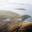
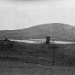
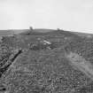
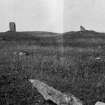
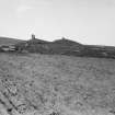
Standing Stones, Crois Mhic Jamain. On two grass-covered contiguous mounds raised on the highest extremity of a slight rocky ridge, and lying NE-SW.
They each measure some 24ft in diameter and rise some 4ft above the general level of the ground. On the summit of each hillock is a small standing stone, the distance between them being 18ft 6ins. The SW slab is rectangular, measuring 3ft in height, 1ft 10ins in breadth and 6ins in thickness: the other is an irregular block 1ft 7ins in height and 5ft in girth (RCAHMS 1928).
A very large skull is said to have been found here.
E Beveridge 1911; RCAHMS 1928.
These stones are as described above.
Surveyed at 1/2500.
Visited by OS (N K B) 2 June 1965.
Field Visit (13 August 1914)
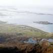
Standing Stones, Crois Mhic Jamain, Port nan Long.
About 400 yards south-west of Port nan Long, near the base of the south-eastern slope of Suenish, are two grass-covered impinging mounds raised on the highest extremity of a slight rocky ridge, and lying north-east and south-west. They each measure some 24 feet in diameter and rise about 4 feet above the general level of the ground. On the summit of each hillock is a small standing stone, the distance between them being 18 feet 6 inches. The stone to the south-west is a rectangular slab measuring 3 feet in height, 1 foot 10 inches in breadth, and 6 inches in thickness, while the other is an irregular block 1 foot 7 inches in height, and 5 feet in girth.
RCAHMS 1928, visited 13 August 1914
OS map: North Uist xxxi.

