
Juniata: Water Sound, Scapa Flow, Orkney


Tanker (20th Century)
Site Name Juniata: Water Sound, Scapa Flow, Orkney
Classification Tanker (20th Century)
Alternative Name(s) Juanita; Ex. Sprucol
Canmore ID 103005
Site Number ND49NE 8022
NGR ND 4812 9518
Datum Datum not recorded
Permalink http://canmore.org.uk/site/103005


- Council Orkney Islands
- Parish Maritime - Orkney
- Former Region Orkney Islands Area
- Former District Maritime
- Former County Not Applicable
ND49NE 8022 4812 9518
N58 50.4833 W2 53.9333
NLO: Water Sound [name centred ND 460 950]
Stromness [name: HY 253 090]
Scapa Flow [name centred HY 36 00].
Formerly entered as Site no. 8955.
For adjacent (and successor) Churchill Barrier No. 4, see ND49NE 17.
For other blockships in this group, see ND49NE 8002-9, and ND49SE 8001.
For plan indicating the relative locations and orientations of blockships in this group, see Macdonald 1990, 125.
Horizontal Datum = OGB
General water depth = 2
Circumstances of Loss Details
-----------------------------
The twin screw steel motor tanker JUANITA, built in 1918, was sunk as a blockship to the NE of the barrier in 1940. Built in Sunderland, registered London.
Sources: Ferguson 1985; MacDonald 1990
Surveying Details
-----------------------------
14 March 1972. A position of 58 50 29N, 002 53 56W is given, or bearing 179 degrees, or 548 metres from the spot height (107) on Burray. A 10.6 metre section of hull remains with decking. The fittings have been removed.
Report by Undermarine Operations, 5 March 1972.
Hydrographic Office, 1995.
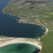
Water Sound is the most southerly of the four sounds that pierce the Eastern side of Scapa Flow. It formerly separated the islands of Burray (to the N) and South Ronaldsay (to the S), but is now crossed by Churchill Barrier No. 4 (ND49NE 17), which blocks it near the E (North Sea) end.
Information from RCAHMS (RJCM), 2 April 2007.
Desk Based Assessment (August 1997)
Throughout the two World Wars Scapa Flow served as the base of the British Home Fleet. Access to these waters was guarded by a series of coastal batteries, booms and blockships. The blockships comprised old and damaged vessels which were deliberately sunk in position so as to form a submarine obstacle to deter enemy incursions. By 1943, the completion of the Churchill barriers, which cut off the eastern approaches to Scapa Flow, rendered the blockships obsolete. After 1945 some of the blockships were dispersed by explosive to clear the shipping lanes while many others were salvaged for parts and metal. The wrecks of several blockships remain on the sea bed and in the inter tidal zone.
(i) The Pontos (ND 49 NE 8002), a 3, 265 ton steel single-screw steamer was built in Glasgow in 1891. She was sunk in 1914 and now rests c.12m offshore to the SE of Water Sound.
(ii) The Clio (ND 49 NE 8006), a 2,733 ton steel single-screw steamer was built in Hartlepool in 1889. She was sunk in 1914 and is visible to the centre of Water Sound at low tide.
(iii) The Lorne (ND 49 NE 8008), a 1,186 ton single-screw steamer was built in Hull in 1873 and sunk in 1915. The wreck was later dispersed by explosives and only fragments now survive.
(iv) The Naja (ND 49 NE 8008), a concrete barge, was sunk in 1939 and lies to the centre of Water Sound.
(v) The Carron (ND 49 NE 8004), a 1, 017 ton single-screw steel steamer, was built in Dundee in 1894. She was sunk as a blockship in 1940 and now lies, partially buried under sand, to the NE side of Churchill Barrier #4.
(vi) The Juniata (ND 49 NE 8022), a twin-screw steel motor tanker, was built in Sunderland in 1918. Sunk in 1940, she now lies to the NE side of Churchill Barrier #4.
(vii) The Gondolier (ND 49 SE 8001) was a 173 ton paddle steamer built in Glasgow in 1866. Sunk in 1940, she now lies on the SE side of the barrier.
(viii) The Collingdoc (ND 49 NE 8005), a 1,1780 ton steel single-screw steamer was built in 1925 in Hill-on-Tees. She was sunk in 1942 and lies partially buried under the sand to the SE end of the barrier.
(ix) Unidentified wreckage (ND 49 NE 8003) stands above HWM.
Reference (2011)
Whittaker ID : 2534
Name : JUNIATA (EX. SPRUCOL)
Latitude : 585029
Longitude : 25356
Date Built : 1918
Registration : LONDON
Type : TANKER (STEEL)
Tonnage : 1139
Tonnage Code : G
Length : 64
Beam : 10
Draught : 5m
Position : All Gone
Loss Day : 17
Loss Month : 4
Loss Year : 1940
Comment : Scuttled as blockship. Refloated 6/1949 to Inganess Bay for BU
Reference (19 April 2012)
UKHO Identifier : 001250
Feature Class : Wreck
State : LIVE
Classification : Unclassified
Position (Lat/long) : 58.84139,-2.89889
Horizontal Datum : ORDNANCE SURVEY OF GREAT BRITAIN (1936)
WGS84 Position (Lat/long) : 58.84097,-2.90051
WGS84 Origin : 3-D Cartesian Shift (BW)
Position Quality : Unreliable
Depth Quality : Depth unknown
Water Depth : 2
Vertical Datum : Lowest Astronomical Tide
Name : JUANITA
Type : BLOCKSHIP
Flag : BRITISH
Tonnage : 1139
Tonnage Type : Gross
Date Sunk : 17/04/1940
Contact Description : Partial wreck
Original Sensor : Reported Sinking
Last Sensor : None reported
Original Detection Year : 1940
Last Detection Year : 1972
Original Source : Other
Last Source : Other
Circumstances of Loss : **TWIN SCREW STEEL M TANKER, BUILT 1918, SUNK AS A BLOCKSHIP TO THE NE OF THE BARRIER.
Surveying Details : **H2496/72 14.3.72 POSN 585029N, 025356W, OR 179DEG, 1800FT FROM SPOT HEIGHT (107) ON BURRAY. 35FT SECTION OF HULL REMAINS WITH DECKING. FITTINGS HAVE BEEN REMOVED. (UNDERMARINE OPERATIONS, 5.3.72). INS AS DWP. BR STD.
**3.7.80 NOT SHOWN ON NC 35. AREA BLUED OUT.
**19.8.80 COVERED BY BLOCKSHIPS SEE NOTE LEGEND ON NE 2162.
**11.12.81 COVERED BY WKS LEGEND ON NC 2250.
Charting Comments : POSN FOR FILING ONLY
Date Last Amended : 09/02/2005
Note (November 2017)
Mistaken identity and split personality
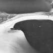
Inganess Bay lies just to the north of Kirkwall airport on the Orkney Islands. A small sandy beach at its south west corner is known as the Sand of Wideford and is a popular place for dog walkers willing to brace the Orcadian wind. Just 130m or so offshore are the remains of a shipwreck with a confusing and complicated story.
The wreck is the bow section of an oil tanker and her story provides a good example of the richness of maritime history and the difficulties in identifying and studying shipwrecks. She is described in websites, books and forums with at least four alternatives being offered as to her identity.
Orkney is unusual in that many of the shipwrecks found in her waters were brought to the island to act as defences against the movement of German U-boats, and to prevent attacks such as the tragic sinking of HMS Royal Oak. The sheltered waters of Scapa Flow provided an ideal deep-water anchorage but the various shallow sounds and deeper channels offered access for enemy as well as allied vessels. One answer to this was the use of blockships, old and worn ships that could be intentionally sunk to provide an obstacle for shipping; another was the construction of physical barriers linking the islands across the shallower sounds.
Many of the blockships that were used had a long history of service, and some had already been renamed once or twice through changing ownership. As they were towed into position some broke up, or were moved over the course of the two World Wars. In later years, some were refloated to be taken away and scrapped, although there are often some archaeological remains left.
The Juniata
This particular wreck was tentatively identified by the Hydrographic Office as the bow section of the Nana (sometimes referred to as the Naja or Majda), a blockship that had been sunk in 1939 within Water Sound and towed to Inganess Bay for scrapping after the war. An alternative explanation was offered in a guide to Scottish shipwrecks in 2003. Here the wreck was confidently described as the bow section of the Vardefjell, a Norwegian tanker that broke apart in heavy seas in 1942. Some local authorities were sure the wreck was in fact the Loch Maddy, a steamship that had been torpedoed near Orkney and towed to Inganess Bay for salvage.
The most plausible explanation (supported by pictorial evidence) is that the wreck is in fact the bow section of the Junaita (sometimes referred to as Juanita), and is only missing a short section of the stern. She was one of the Admiralty designed 1,000 ton oil tankers, and was built at Short Bros. shipyard in Sunderland, launching in January 1918 with the original name Sprocol. Just a few months later she was torpedoed and severely damaged by a German submarine but managed to limp back to Hull, where she underwent repairs for four months. In March 1920 the rebuilt tanker was sold to the Anglo American Oil Company and renamed Juniata serving as an oil tanker for nearly 20 years.
Presumably sold by the oil company, the Juniata was sunk as a blockship in Water Sound on 17 April 1940, in a position almost adjacent to the Naja mentioned above. In July 1949 the Juniata was raised for scrapping and towed north around the coastline of Orkney. En route it was found that she was in such poor condition that she would have to be towed ashore and she was beached at Inganess Bay.
Shipwrecks, even those of a relatively recent age, give a fresh perspective on the past. Their mobility makes them a physical expression of the cultural connectedness so often studied by archaeologists: a ship like Juniata will no doubt have travelled all over the world during her 22 year working life. They also present a specific challenge to researchers and heritage managers. The Juniata has two records in Canmore, one reflecting her original position as a blockship, were parts of her hull may remain, the other her ‘new’ position on Inganess beach. The perfectly understandable confusion over her identity is simply a product of the number and density of shipwrecks in Orkney’s waters, and can often only be resolved by the recovery of a ship’s bell, or the careful study of historic photographs.
Author: George Geddes, Archaeologist, Survey and Recording

