
North Uist, Cringraval


Stone Circle (Neolithic) - (Bronze Age)
Site Name North Uist, Cringraval
Classification Stone Circle (Neolithic) - (Bronze Age)
Canmore ID 10283
Site Number NF86SW 40
NGR NF 81161 64453
NGR Description Centred NF 81161 64453
Datum OSGB36 - NGR
Permalink http://canmore.org.uk/site/10283


- Council Western Isles
- Parish North Uist
- Former Region Western Isles Islands Area
- Former District Western Isles
- Former County Inverness-shire
Field Visit (12 September 1914)
Stone Circle, Cringraval, Clachan-a-luib.
Towards the W end of the summit of Cringraval, near Clachan-a-Luib, about 460 yards WSW of NF86SW 21, some 100ft OD, are the remains of a stone circle exposed through the removal of peat, which is about 3 ft deep at this place. The E half of the circle has been laid bare, and possibly some of the stones on its W half may still be hidden under peat. The circle is about 120ft in diameter.
Seven stones survive, of which only three remain erect (only one being upright), and of the four prostrate examples one has been roughly dressed for a lintel, but has not been removed. The highest of the erect stones stands on the E of the circle and measures 4ft 1in in height, 5ft 3ins in girth at the base, expanding to 6ft 9ins near the top; the two other pillars to the NE and S are 2ft 3ins high, 2ft 9ins wide, and 7ins thick; and 3ft high, 3ft 6ins wide, and 9ins thick respectively, while the largest prostrate stone measures 5ft 10ins in length and 4ft 10ins in breadth.
RCAHMS 1928, visited 12 September 1914.
OS map: North Uist xxxix (unnoted).
Field Visit (24 September 2010)
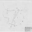
Measuring 46.7m in diameter, this large stone circle comprises an incomplete circuit of twelve stones together with a fallen and possibly displaced pillar located towards its centre. When first recorded in 1914, only the seven stones forming the E half were visible, having been exposed through peat cutting. Today, the edge of a peat baulk runs NNE and SSW across the W half of the circle, and a further five stones can be seen, the two in the SW quadrant still partly embedded in the peat. Of the stones, four remain in situ but now lean, while the remaining eight have fallen and are displaced.
The stones are described clockwise from the N:
NF 81170 64465: this prostrate slab is aligned N and S and part grass grown. It measures 1.6m in length by at least 0.25m in thickness, tapering from 0.8m to 0.3m in breadth.
NF 81177 64455: this upright slab is aligned NNW and SSE and is possibly broken. Now leaning towards the WSW, it measures 0.75m in breadth by 0.2m in thickness and 0.7m in height. The smooth outer face contrasts with a rougher inner face where it has been split from bedrock, and there is a possible chocking stone at its foot.
NF 81177 64452: this prostrate stone is aligned E and W, has been dressed for a lintel and now lies on the ground surface. It measures 1.4m in length by 0.15m in thickness, tapering from 0.45m to 0.35m in breadth.
NF 81176 64445: this upright slab of granite is aligned NNE and SSW, and set up on edge, though possibly re-erected in this position on its side and apparently not earthfast. It measures 1.85m in breadth by 0.35m in thickness at ground level and 0.65m in height. Its inner face is sheer, whereas its outer face is rough and weathered. There is a possible chocking stone at its S end.
NF 81171 64437: this prostrate slab is aligned ENE and WSW, and measures, 1.8m in length by 1.4m in breadth and 0.15m in thickness. A loose stone lies to the WSW.
NF 81160 64433: this prostrate stone is aligned NNE and SSW, but only the tip is visible and the rest is buried in grass-grown peat. It measures at least 1.5m in length by 0.95m in breadth at what was probably its base, where the surface of the stone bears prominent ridging.
NF 81153 64432: this upright slab is aligned E and W and now leans towards the interior where there is a waterfilled hollow at the foot of its inner face. Measuring 0.95m in breadth by 0.2m in thickness at ground level, the top of the slab is rough, suggesting that it has been broken off at a height of 1m. A partly buried stone to the ESE is grass grown.
NF 81146 64428: this stone, part of which is visible in the edge of a peat cutting adjacent to outcrop, measures 1.4m in length by 1.05m in breadth and 0.5m in thickness.
NF 81141 64437: only the tip of this stone is exposed in the peat cutting.
NF 81133 64464: this upright stone block is aligned NNE and SSW and now leans towards the ESE. Possibly re-erected on its side, it measures 1.7m in breadth by 0.35m in thickness and 0.7m in height. There are several stones between this and the next.
NF 81136 64471: this slightly rounded slab is aligned NNE and SSW and has fallen outwards on the edge of peat cutting with outcrop 3m to the N. It measures 1.4m in length by at least 1m in breadth and 0.1m in thickness,
NF 81159 64478: this prostrate slab is aligned NNE and SSW, and apparently now lies above a void. A relatively large stone, it measures at least 2m in length by 1.5m in breadth and 0.4m in thickness. A small pile of stones stands adjacent and is probably made up of stones found during peat cutting.
NF 81161 64453: this prostrate pillar-like stone lies almost central to the circle. Aligned NNE and SSW, it measures 1.4m in length by at least 0.3m in thickness and tapers from 0.8m to 0.5m in breadth.
Visited by RCAHMS (ARG,SPH) 24 September 2010
Measured Survey (19 September 2012)
RCAHMS surveyed Cringraval stone circle on 29 August 2012 with plane-table and alidade producing a plan at a scale of 1:200. The plan was used as the basis of an illustration redrawn in vector graphics software.

