
Following the launch of trove.scot in February 2025 we are now planning the retiral of some of our webservices. Canmore will be switched off on 24th June 2025. Information about the closure can be found on the HES website: Retiral of HES web services | Historic Environment Scotland
Consolidated Catalina Flying Boat: Ferry Point, Great Cumbrae, Firth Of Clyde


Aircraft (20th Century)
Site Name Consolidated Catalina Flying Boat: Ferry Point, Great Cumbrae, Firth Of Clyde
Classification Aircraft (20th Century)
Alternative Name(s) 'Cumbrae Catalina'; 'largs Catalina'; Largs Channel; Little Cumbray; Inner Clyde Estuary; Unknown; A/c Consolidated
Canmore ID 102752
Site Number NS15NE 8001
NGR NS 18499 58607
Datum WGS84 - Lat/Long
Permalink http://canmore.org.uk/site/102752


- Council North Ayrshire
- Parish Maritime - North Ayrshire
- Former Region Strathclyde
- Former District Maritime
- Former County Not Applicable
NS15NE 8001 1846 5861
N55 47.2 W4 53.7
NLO: Great Cumbrae Island [name centred NS 17 57]
Little Cumbrae Island [name centred NS 14 51]
Largs [name: NS 202 595]
Largs Bay [name centred NS 199 599].
Formerly entered as NS15NE 8004, Site nos. 9387 and 9390 at cited location NS 1844 5861 [N55 47.2, W04 53.75].
For (associated) Largs Seaplane Base, see NS26SW 44.
(Transits illustrated).
G Ridley 1984.
(Location cited as NS 202 600). CATALINA. Transits for locating the wreckage are illustrated in the source, along with a sketch of the structure.
[NB: the sketch illustrates a 4 engine flying boat. If the sketch is correct, then this cannot be a Catalina, which is a 2 engined type].
Butland & Siedlecki, BSAC Wreck Register 1987.
Horizontal Datum = OGB
General water depth = 12
Circumstances of Loss Details
-----------------------------
This Catalina Flying Boat sank at its moorings during World War II.
Surveying Details
-----------------------------
23 December 1980. The broken up remains of a Consolidated PBY, Catalina Flying Boat are reported at 55 47 12N, 004 53 42W, lying between the National Watersports Centre and the ferry terminal at north end of the centre's mooring trot.
Source; BSAC Wreck Register, Vol III.
12 May 1986. The wreck was not found during survey, but it was not especially searched for.
Report by HMS GLEANER.
Hydrographic Office, 1995.
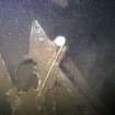
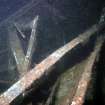
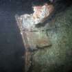
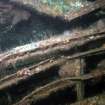
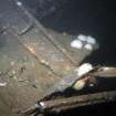
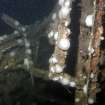
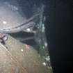
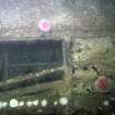
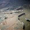
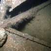
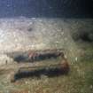
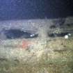
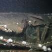
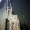
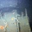
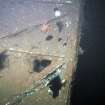
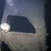
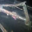
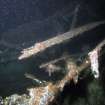
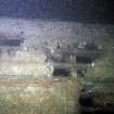
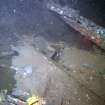
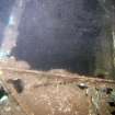
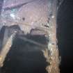
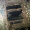
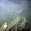
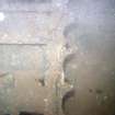
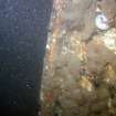
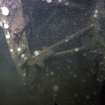
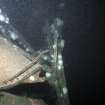
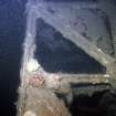
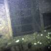
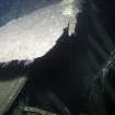
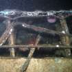
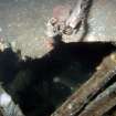
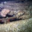
This wreck is aligned roughly NNE (bow)-SSW (tail) at a depth of 23m on a near-level seabed of sand and shell in an area of high-energy environment (being profusely covered with anemones), and has suffered significant deterioration since it was described by Butland and Siedlecki. The shotline leads to the trailing edge of the starboard wing which has broken off; the wingtip, control surfaces and some of the surface are missing but the (rectangular) torsion box can be clearly distinguished at the inboard end. The after fuselage has been distorted and twisted to starboard, its construction of longitudinal stringers being clearly visible in the area around the former blisters. The empennage has been reduced to tangled metal and the port wing to a stump which is currently lying nearly-flat across the mid-section of the fuselage. The nose section has become separated but may survive some way away, unrecognised in the dark conditions pertaining at the date of visit; neither engine-bearers nor wheel-recesses could be identified.
The mark of aircraft could not be identified from the surviving remains, but the extensive damage to the stern may suggest loss through anchor-dragging, a common cause of seaplane casualties particularly when away from an operating base and without fixed moorings.
Visited by Edith Butler, Mike Hossack and Bob Mowat (South Queensferry Sub-Aqua Club, BSAC 1262), 18 May 1997.
W E Butland and J K Siedlecki 1987.
(Classified as Consolidated Catalina PBY-5: no date of loss specified). Unknown: this aircraft lies in 16 metres [depth] close inshore.
Registration: British.
(Location of loss cited as N55 47.17 W4 53.83).
I G Whittaker 1998.
Material reported under RoW amnesty (2001):
(Name cited as Little Cumbray).
A090 1 part of aleron (?) [aileron] assembly, all made of aluminium (from seabed).
NMRS, MS/829/32.
Material reported under RoW amnesty (2001):
A1982 1 brass whistle: from seabed.
NMRS, MS/829/35.
This wreck has been adopted [under the NAS Adopt-a-Wreck scheme] by Midway Watersports in Leeds. Mr Steve Hunter has reported to NAS that since November 2002 (when the group last visited the site) it has completely turned over (presumably by dragging anchors) and parts of it have become scattered on the seabed.
(Address: H2O Archaeological Group, c/o Steve Hunter, 2 High Street, Morley, Leeds LS27 9AW).
Information from Mark Beattie-Edwards (Training and Administration Officer, Nautical Archaeology Society), 24 February and 5 December 2003.
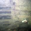
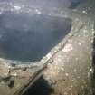
The remains of this aircraft lie in the Largs Channel just off Great Cumbrae and form a popular dive site. They lie on a soft muddy bottom in 22m depth of water and form a reef which attracts pollack, ling and conger.
The wreck has been monitored monthly over the past three years by twelve divers from the Midway Watersports Archaeology Group (Leeds). Deterioration (apparently at an increasing rate) has been noted over this period, and probably results from anchor damage, to which such light aluminium structures are inherently prone. In February 2003 the wing (lying E-W across the fuselage) was found to have moved so as to lie on its edge.
(The significance of this wreck is stressed and options for administrative protection and buoyage are considered. Detail photographs of the after bulkhead and a portion of the wing are reproduced).
Source: S Hunter and P Robertson in Nautical Archaeology [NAS newsletter], 2003.2 (May 2003), 1-2.
External Reference (1987)
(Location cited as NS 202 600). CATALINA. Transits for locating the wreckage are illustrated in the source, along with a sketch of the structure.
[NB: the sketch illustrates a 4 engine flying boat. If the sketch is correct, then this cannot be a Catalina, which is a 2 engined type].
Butland & Siedlecki, BSAC Wreck Register 1987.
Evidence Of Loss (1995)
Horizontal Datum = OGB
General water depth = 12
Circumstances of Loss Details
-----------------------------
This Catalina Flying Boat sank at its moorings during World War II.
Surveying Details
-----------------------------
23 December 1980. The broken up remains of a Consolidated PBY, Catalina Flying Boat are reported at 55 47 12N, 004 53 42W, lying between the National Watersports Centre and the ferry terminal at north end of the centre's mooring trot.
Source; BSAC Wreck Register, Vol III.
12 May 1986. The wreck was not found during survey, but it was not especially searched for.
Report by HMS GLEANER.
Hydrographic Office, 1995.
Evidence Of Loss (18 May 1997)
This wreck is aligned roughly NNE (bow)-SSW (tail) at a depth of 23m on a near-level seabed of sand and shell in an area of high-energy environment (being profusely covered with anemones), and has suffered significant deterioration since it was described by Butland and Siedlecki. The shotline leads to the trailing edge of the starboard wing which has broken off; the wingtip, control surfaces and some of the surface are missing but the (rectangular) torsion box can be clearly distinguished at the inboard end. The after fuselage has been distorted and twisted to starboard, its construction of longitudinal stringers being clearly visible in the area around the former blisters. The empennage has been reduced to tangled metal and the port wing to a stump which is currently lying nearly-flat across the mid-section of the fuselage. The nose section has become separated but may survive some way away, unrecognised in the dark conditions pertaining at the date of visit; neither engine-bearers nor wheel-recesses could be identified.
The mark of aircraft could not be identified from the surviving remains, but the extensive damage to the stern may suggest loss through anchor-dragging, a common cause of seaplane casualties particularly when away from an operating base and without fixed moorings.
Visited by Edith Butler, Mike Hossack and Bob Mowat (South Queensferry Sub-Aqua Club, BSAC 1262), 18 May 1997.
W E Butland and J K Siedlecki 1987.
Evidence Of Loss (1998)
(Classified as Consolidated Catalina PBY-5: no date of loss specified). Unknown: this aircraft lies in 16 metres [depth] close inshore.
Registration: British.
(Location of loss cited as N55 47.17 W4 53.83).
I G Whittaker 1998.
Evidence Of Loss (2001)
Material reported under RoW amnesty (2001):
(Name cited as Little Cumbray).
A090 1 part of aleron (?) [aileron] assembly, all made of aluminium (from seabed).
NMRS, MS/829/32.
Material reported under RoW amnesty (2001):
A1982 1 brass whistle: from seabed.
NMRS, MS/829/35.
External Reference (24 February 2003 - 5 December 2003)
This wreck has been adopted [under the NAS Adopt-a-Wreck scheme] by Midway Watersports in Leeds. Mr Steve Hunter has reported to NAS that since November 2002 (when the group last visited the site) it has completely turned over (presumably by dragging anchors) and parts of it have become scattered on the seabed.
(Address: H2O Archaeological Group, c/o Steve Hunter, 2 High Street, Morley, Leeds LS27 9AW).
Information from Mark Beattie-Edwards (Training and Administration Officer, Nautical Archaeology Society), 24 February and 5 December 2003.
External Reference (May 2003)
The remains of this aircraft lie in the Largs Channel just off Great Cumbrae and form a popular dive site. They lie on a soft muddy bottom in 22m depth of water and form a reef which attracts pollack, ling and conger.
The wreck has been monitored monthly over the past three years by twelve divers from the Midway Watersports Archaeology Group (Leeds). Deterioration (apparently at an increasing rate) has been noted over this period, and probably results from anchor damage, to which such light aluminium structures are inherently prone. In February 2003 the wing (lying E-W across the fuselage) was found to have moved so as to lie on its edge.
(The significance of this wreck is stressed and options for administrative protection and buoyage are considered. Detail photographs of the after bulkhead and a portion of the wing are reproduced).
Source: S Hunter and P Robertson in Nautical Archaeology [NAS newsletter], 2003.2 (May 2003), 1-2.
Diver Inspection (2003)
Reference (2011)
Whittaker ID : 275
Name : A/C CONSOLIDATED
Latitude : 554710
Longitude : 45350
Registration : BRITISH
Type : CATALINA PBY-5
Position : Exact Position
Comment : Unidentified Catalina lying in 16 metres, close inshore.
Reference (19 April 2012)
UKHO Identifier : 004141
Feature Class : Wreck
State : DEAD
Classification : Unclassified
Position (Lat/long) : 55.78667,-4.89500
Horizontal Datum : ORDNANCE SURVEY OF GREAT BRITAIN (1936)
WGS84 Position (Lat/long) : 55.78660,-4.89618
WGS84 Origin : 3-D Cartesian Shift (BW)
Position Quality : Unreliable
Depth Quality : Depth unknown
Water Depth : 20
Vertical Datum : Lowest Astronomical Tide
Name : UNKNOWN
Type : CATALINA FLYING BOAT
Contact Description : Aircraft
Original Sensor : Reported Sinking
Original Detection Year : 1980
Original Source : Other
Circumstances of Loss : **SANK AT MOORINGS DURING WW II.
Surveying Details : **23.12.80 BROKEN UP REMAINS OF A CONSOLIDATED PBY, CATALINA FLYING BOAT IS REPD IN 554712N, 045342W [OGB]. LYING BETWEEN NATIONAL WATERSPORTS CENTRE AND FERRY TERMINAL AT N END OF THE CENTRE'S MOORING TROT. (BSAC WK REGISTER,VOL III).
**H2885/83 12.5.86 NOT FOUND DURING SURVEY, BUT NOT SEARCHED FOR. (HMS GLEANER, HI 165C). AMENDED TO DEAD. NCA.
Charting Comments : POSN FOR FILING ONLY
Date Last Amended : 15/07/2003

