
Pricing Change
New pricing for orders of material from this site will come into place shortly. Charges for supply of digital images, digitisation on demand, prints and licensing will be altered.
Upcoming Maintenance
Please be advised that this website will undergo scheduled maintenance on the following dates:
Thursday, 9 January: 11:00 AM - 3:00 PM
Thursday, 23 January: 11:00 AM - 3:00 PM
Thursday, 30 January: 11:00 AM - 3:00 PM
During these times, some functionality such as image purchasing may be temporarily unavailable. We apologise for any inconvenience this may cause.
Gartmore: East Weddell Sound, Scapa Flow, Orkney


Craft (20th Century), Obstruction (Period Unassigned), Steamship (20th Century)
Site Name Gartmore: East Weddell Sound, Scapa Flow, Orkney
Classification Craft (20th Century), Obstruction (Period Unassigned), Steamship (20th Century)
Alternative Name(s) Gartshore; Castilla; Bedford; Iberial Saint Gothard; East Weddel Sound; Churchill Causeway; Churchill Barrier No. 3; North Sea
Canmore ID 102356
Site Number ND49NE 8012
NGR ND 47353 98537
Datum WGS84 - Lat/Long
Permalink http://canmore.org.uk/site/102356


- Council Orkney Islands
- Parish Maritime - Orkney
- Former Region Orkney Islands Area
- Former District Maritime
- Former County Not Applicable
ND49NE 8012 4735 9853
N58 52.2833 W2 54.7833
NLO: Weddell Sound [name centred ND 477 988]
Stromness [name: HY 253 090]
Scapa Flow [name centred HY 36 00].
Formerly entered as Site no. 8901.
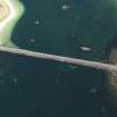
For adjacent and successor causeway (Churchill Barrier no. 3), see ND49NE 16.
For other blockships in this group, see ND49NE 8001 and ND49NE 8011 -12 and 8013.
For plan indicating the relative locations and orientations of blockships in this group, see Macdonald 1990, 125.
Horizontal Datum = OGB
Buoyage =
General water depth = 5
Circumstances of Loss Details
-----------------------------
The iron single-screw steamship GARTSHORE was built in 1880 and sunk as a blockship. Built at South Shields and registered there.
Sources; Ferguson 1985; MacDonald 1990
Surveying Details
-----------------------------
9 July 1926. The wreck's position is given as 58 52 17.01N, 002 54 47W [LAPLAND and REGINALD are in the same position].
14 March 1972. There is no sign of a wreck in this area. There are none of the characteristic rust stains of a wreck that has been removed and no trace of even the smallest debris.
Report by Undermarine Operations, 5 March 1972.
28 August 1992. The GARTSHORE mingles with that of the EMPIRE SEAMAN on the W side of the barrier.
Source: MacDonald 1990
Note: the position given in 1926 would appear incorrect if the vessel lies on the west side of the barrier.
Hydrographic Office, 1995.
(Classified as iron steamship: former names cited as Castilla and Bedford, and date of loss as 14 September 1914). Gartmore: this vessel was scuttled as a blockship. (Gartshore?).
Rgistration: British. Built 1879. 1774grt. Length: 82m. Beam: 11m.
(Location of loss cited as N58 52.28 W2 54.78).
I G Whittaker 1998.
(Name cited as Gartmore).
Length: 270 ft (82.3m): date of sinking 14 September 1914.
'Unballasted. Broken up. Poop ashore. Forecastle visible at H.W.' (Report dated 28 June 1915 and accompanying panoramic sketch dated 8 December 1915).
The accompanying panoramic drawing (of East Weddel Sound, looking W from the N point of Burray) depicts only an indeterminate portion (presumably the bow) of this vessel hard against the shore of Glimps Holm. Neither mast nor funnels remain erect.
The accompanying map depicts this vessel in hatched outline as lying N-S against the shore of Glimps Holm. It is thus the most northerly blockship of the group.
Information from RCAHMS (RJCM), 30 January 2004.
PRO [Kew] ADM116/2073A: dated 17 December 1919.
Field Visit (August 1997)
Throughout the two World Wars Scapa Flow served as the base of the British Home Fleet. Access to these waters was guarded by a series of coastal batteries, booms and blockships. The blockships comprised old and damaged vessels which were deliberately sunk in position so as to form a submarine obstacle to deter enemy incursions. By 1943, the completion of the Churchill barriers, which cut off the eastern approaches to Scapa Flow, rendered the blockships obsolete. After 1945 some of the blockships were dispersed by explosive to clear the shipping lanes while many others were salvaged for parts and metal. The wrecks of several blockships remain on the sea bed and in the inter tidal zone.
(i) To the E side of Churchill Barrier #3, the wreck of the Reginald (ND 49 NE 8010) lies in shallow water. This 930 tons iron three-masted motor schooner was built in 1878 in Glasgow and was sunk in 1915. The stern section of the hull is visible above the water line.
(ii) The Lapland (ND 49 NE 8013), a 1,234 ton steel single-screw steamer was built in Dundee in 1890 and registered in Liverpool. Little of this blockship is now visible, since the barrier was constructed over it.
(iii) The Gartshore (ND 49 NE 8012), a 1,564 tons iron single-screw steamer, was built and registered in South Shields. She lies to the W side of the barrier.
(iv) The Martis (ND 49 NE 8011), a 2,483 ton steel single-screw steamer, was built in South Shields in 1894. She lies to the W side of the barrier.
(v) The Empire Seaman (ND 49 NE 8001) )was a steel single-screw steamer of 1,921 tons. Built in Lubeck in 1922, she was seized by the Royal Navy in 1940 and sunk as a blockship. She lies to the W side of the barrier.
Moore and Wilson, 1997
Coastal Zone Assessment Survey
Reference (2011)
Whittaker ID : 2548
Name : GARTMORE (EX. CASTILLA, BEDFORD)
Latitude : 585217
Longitude : 25447
Date Built : 1879
Registration : BRITISH
Type : SS (IRON)
Tonnage : 1774
Tonnage Code : G
Length : 82
Beam : 11
Draught : 7m
Position : Exact Position
Loss Day : 14
Loss Month : 9
Loss Year : 1914
Comment : Scuttled as a blockship. (GARTSHORE ?)
Reference (19 April 2012)
UKHO Identifier : 001256
Feature Class : Obstn
State : LIVE
Classification : Unclassified
Position (Lat/long) : 58.87139,-2.91306
Horizontal Datum : ORDNANCE SURVEY OF GREAT BRITAIN (1936)
WGS84 Position (Lat/long) : 58.87098,-2.91466
WGS84 Origin : 3-D Cartesian Shift (BW)
Position Quality : Unreliable
Depth Quality : Depth unknown
Water Depth : 5
Vertical Datum : Lowest Astronomical Tide
Name : GARTSHORE
Type : BLOCKSHIP
Flag : BRITISH
Tonnage : 1564
Tonnage Type : Gross
Date Sunk : 14/09/1914
Contact Description : Notable debris
Original Sensor : Reported Sinking
Last Sensor : None reported
Original Detection Year : 1914
Last Detection Year : 1992
Original Source : Other
Last Source : Other
Circumstances of Loss : **IRON SINGLE-SCREW SS, BUILT 1880, SUNK AS A BLOCKSHIP. (WKS OF SCAPA FLOW, DIVE SCAPA FLOW).
Surveying Details : **H3875/26 9.7.26 POSN 585217.01N, 025447W. (LAPLAND & REGINALD IN SAME POSN).
**H7308/56 13.5.59 INS CAUTION NOTE ON 35. - NM 1924/58.
**H2496/72 14.3.72 THERE IS NO SIGN OF A WK IN THIS AREA. THERE ARE NONE OF THE CHARACTERISTIC RUST STAINS OF A WK THAT HAS BEEN REMOVED AND NO TRACE OF EVEN THE SMALLEST DEBRIS. (UNDERMARINE OPERATIONS 5.3.72).
**H2496/72 14.3.72 COVERED BY 'OBSTRUCTION - SEE NOTE' LEGEND ON NC 35.
**28.8.92 WRECKAGE OF GARTSHORE MINGLES WITH THAT OF THE EMPIRE SEAMAN ON W SIDE OF BARRIER. (DIVE SCAPA FLOW). POSN GIVEN IN 1926 WOULD APPEAR INCORRECT IF VESSEL LIES ON W SIDE OF BARRIER.
Charting Comments : POSN FOR FILING ONLY
Date Last Amended : 09/02/2005
Project (2013 - 2014)
The Scapa Flow 2013 Marine Archaeology Survey Project, commissioned by Historic Scotland, undertook remote sensing surveys and archaeological diving evaluations at some of the sites within Scapa Flow, Orkney and at the Churchill Barriers.
The project aimed to establish or confirm the identification, extent of survival, character and condition of around 28 known but mostly poorly recorded First and Second World War wreck sites, 8 salvage sites, several sites thought to be associated with Second World War Boom Defences, and a limited sample of geophysical features identified in previous studies (Project Adair).
The work built on that of previous surveys including those completed as part of the ScapaMap Project (2001 and 2006) and by Wessex Archaeology Scapa Flow Wrecks Survey (2012), amongst others.
The project was completed by ORCA Marine and SULA Diving
Diver Inspection (2013)
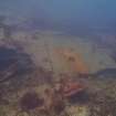
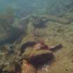
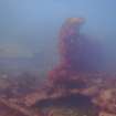
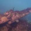
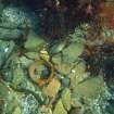
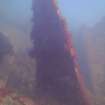
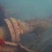
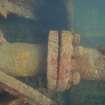
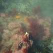
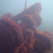
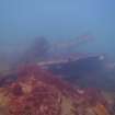
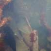
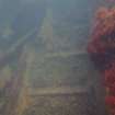
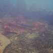
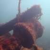
58 52.283 N 2 54.784 W The dispersed remains of a well broken-down vessel lie on a rock and sand bottom with mixed seaweeds in about 3m – 5m of water. The remains have a light coverage of short animal turf. It is not possible to provide an accurate measurement for the debris field as it is too dispersed. The wreckage can be affected by light swell but is generally sheltered from tide.
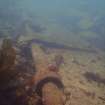
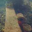
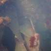
A rudder and one blade of a part buried propeller were noted to the stern of the vessel. The propeller is not attached to the propeller shaft, suggesting it has moved. The propeller shaft runs from north to south and is encased within part of the propeller shaft tunnel. A large winch gear and a small section of ladder were noted to the east of the stern section, while a large section of steel plating and ribs were identified to the west.
There is a large crankshaft between these remains and those of the SS Empire Seaman, and it is unclear to which wreck the crankshaft is associated with varying accounts in different sources (Macdonald 1993:120 c.f. Wood 2008: 128).
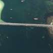
There are several lengths of line entangled with the remains and evidence of abandoned creels.
Analysis
Historical documents and image confirm that these are the remains of the SS Gartmore, not the SS Gartshore as previously reported. ADM X96-4 and associated maps and sketch record the remains as the SS Gartmore. This is supported by the Stark Shell records for the two vessels. These records demonstrate that the SS Gartshore was only purchased by the Admiralty in 1915. This is after the ADM document ADM 1-8428-216 records the SS Gartmore was sunk. The Stark Shell records indicate that the SS Gartshore was used as a mooring hulk.
Built by Tyne Iron Shipbuilding Co., Newcastle for W. H. Atkinson, North Shields in 1879 the SS Gartmore had several owners. The vessel was sold to the Admiralty in 1914 and was sunk as a blockship in Weddell Sound on the 14th September 1914.
While both the SS Gartmore and the SS Gartshore were owned by Gart SS. Co., Ltd, the SS Gartshore was only sold to the Admiralty in 1915.
Macdonald (1993) noted that the remains of the SS Gartshore were at one stage visible at low water with those of the SS Martis and SS Empire Seaman.
These remains are no longer visible, which which could suggest they have become more broken down since his book was written.
Information from Annalisa Christie, Kevin Heath and Mark Littlewood (ORCA) March 2014
Side Scan Sonar Survey (2013)
58 52.283 N 2 54.784 W Although side scan surveys were attempted, no images were retrieved as the remains were too shallow to be accessed safely.
Information from Annalisa Christie, Kevin Heath and Mark Littlewood (ORCA) March 2014

