
Following the launch of trove.scot in February 2025 we are now planning the retiral of some of our webservices. Canmore will be switched off on 24th June 2025. Information about the closure can be found on the HES website: Retiral of HES web services | Historic Environment Scotland
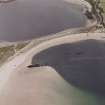
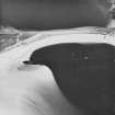
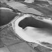
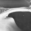
Pontos: Water Sound, Scapa Flow, Orkney


Craft (20th Century), Steamship (20th Century)
Site Name Pontos: Water Sound, Scapa Flow, Orkney
Classification Craft (20th Century), Steamship (20th Century)
Alternative Name(s) St John City; Clan Macnab; Churchill Causeway; Churchill Barrier No. 4; North Sea; Pontos; Pontos (Ex. St John City, Clan Macnab)
Canmore ID 102203
Site Number ND49NE 8002
NGR ND 47978 95035
Datum WGS84 - Lat/Long
Permalink http://canmore.org.uk/site/102203


- Council Orkney Islands
- Parish Maritime - Orkney
- Former Region Orkney Islands Area
- Former District Maritime
- Former County Not Applicable
ND49NE 8002 4797 9503
N58 50.4017 W2 54.0833
NLO: Water Sound [name centred ND 460 950]
Stromness [name: HY 253 090]
Scapa Flow [name centred HY 36 00].
Formerly entered as Site no. 8739.
For adjacent (and successor) Churchill Barrier No. 4, see ND49NE 17.
For other blockships in this group, see ND49NE 8003-9 and 8022, and ND49SE 8001.
For plan indicating the relative locations and orientations of blockships in this group, see Macdonald 1990, 125.
Quality of fix = PHOT
Horizontal Datum = OGB
General water depth = 10
Orientation of keel/wreck = 043223
Circumstances of Loss Details
-----------------------------
The steel single-screw SS PONTOS was built 1891 and sunk as a blockship.
Source: Wrecks of Scapa Flow.
Surveying Details
-----------------------------
14 March 1972. The wreck's position is given as 58 50 22N, 002 54 10W, or bearing 196.5 degrees, 792 metres from the spot height (107) on Burray. The entire hull is intact with the bows towards beach. The bow of the wreck shows about 2.4 metres at highwater, with the davit aft also showing. At low water all the ship shows. The forward superstructure is there, but the bridge has collapsed. There is a big gash amidships. The holds have a layer of concrete and rocks which makes the wreck very strong. The propeller and shaft are submerged. The stern runs into Clio. Two masts are intact.
Report by Undermarine Operations, 5 March 1972.
9 March 1976. A large portion of this hulk is visible above the level of mean low water. The stern is either below water level or has been broken off. The portion above water is about 85 metres long, and the keel is orientated 043.5/223.5 degree. The hulk's position is 58 50 24.1N, 002 54 05.0W. This wreck coincides with position of the wreck PONTOS.
Source; Ordnance survey aerial photography dated 16 May 1973.
1 September 1992. The wreck lies 12 metres off the SE end of the barrier. It is clearly visible. The forward section of hull has a distictive tall mast still standing. Two empty lifeboat davits can be seen just aft of the mast. The wreck is well corroded but substantially intact.
Source: MacDonald 1990
Hydrographic Office, 1995.
(Classified as steel steamship: former names cited as St John City and Clan MacNab, and date of loss as 1914). Pontos: this vessel was scuttled as a blockship in Water Sound.
Registration: Andross. Built 1891. 2265grtr. Length: 93m. Beam: 12m.
(Location of loss cited as N58 50.40 W2 54.08).
I G Whittaker 1998.
Length: 305 ft (93m): date of sinking 30 November 1914.
'Ballasted. Back broken amidships. Upright and in good condition. Will last a long time.' (Report dated 28 June 1915 and accompanying panoramic sketch dated 8 December 1915).
The accompanying panoramic drawing (of Water Sound, looking E from Burray Pier) depicts this vessel from the starboard beam, partly obscuring the Clio I (ND49NE 8006). The vessel appears to have been a flush-decked cargo vessel with minimal poop and fo'c'sle; the masts and funnel remain erect. The vessel lies level in the water, the water level being about that found in service.
The accompanying map depicts this vessel in hatched outline and as lying N-S against the Ronaldsay shore. The bow is to the S and this is the most southerly blockship of the group.
Information from RCAHMS (RJCM), 30 January 2004.
PRO [Kew] ADM116/2073A: dated 17 December 1919.
Water Sound is the most southerly of the four sounds that pierce the Eastern side of Scapa Flow. It formerly separated the islands of Burray (to the N) and South Ronaldsay (to the S), but is now crossed by Churchill Barrier No. 4 (ND49NE 17), which blocks it near the E (North Sea) end.
Information from RCAHMS (RJCM), 2 April 2007.
Desk Based Assessment (August 1997)
Throughout the two World Wars Scapa Flow served as the base of the British Home Fleet. Access to these waters was guarded by a series of coastal batteries, booms and blockships. The blockships comprised old and damaged vessels which were deliberately sunk in position so as to form a submarine obstacle to deter enemy incursions. By 1943, the completion of the Churchill barriers, which cut off the eastern approaches to Scapa Flow, rendered the blockships obsolete. After 1945 some of the blockships were dispersed by explosive to clear the shipping lanes while many others were salvaged for parts and metal. The wrecks of several blockships remain on the sea bed and in the inter tidal zone.
(i) The Pontos (ND 49 NE 8002), a 3, 265 ton steel single-screw steamer was built in Glasgow in 1891. She was sunk in 1914 and now rests c.12m offshore to the SE of Water Sound.
(ii) The Clio (ND 49 NE 8006), a 2,733 ton steel single-screw steamer was built in Hartlepool in 1889. She was sunk in 1914 and is visible to the centre of Water Sound at low tide.
(iii) The Lorne (ND 49 NE 8008), a 1,186 ton single-screw steamer was built in Hull in 1873 and sunk in 1915. The wreck was later dispersed by explosives and only fragments now survive.
(iv) The Naja (ND 49 NE 8008), a concrete barge, was sunk in 1939 and lies to the centre of Water Sound.
(v) The Carron (ND 49 NE 8004), a 1, 017 ton single-screw steel steamer, was built in Dundee in 1894. She was sunk as a blockship in 1940 and now lies, partially buried under sand, to the NE side of Churchill Barrier #4.
(vi) The Juniata (ND 49 NE 8022), a twin-screw steel motor tanker, was built in Sunderland in 1918. Sunk in 1940, she now lies to the NE side of Churchill Barrier #4.
(vii) The Gondolier (ND 49 SE 8001) was a 173 ton paddle steamer built in Glasgow in 1866. Sunk in 1940, she now lies on the SE side of the barrier.
(viii) The Collingdoc (ND 49 NE 8005), a 1,1780 ton steel single-screw steamer was built in 1925 in Hill-on-Tees. She was sunk in 1942 and lies partially buried under the sand to the SE end of the barrier.
(ix) Unidentified wreckage (ND 49 NE 8003) stands above HWM.
Reference (2011)
Whittaker ID : 2530
Name : PONTOS (EX. ST JOHN CITY, CLAN MACNAB)
Latitude : 585024
Longitude : 25405
Date Built : 1891
Registration : ANDROS
Type : SS (STEEL)
Tonnage : 2265
Tonnage Code : G
Length : 93
Beam : 12
Draught : 7m
Position : Exact Position
Loss Year : 1914
Comment : Scuttled as a blockship in Water Sound
Reference (19 April 2012)
UKHO Identifier : 001246
Feature Class : Wreck
State : LIVE
Classification : Unclassified
Position (Lat/long) : 58.84003,-2.90139
Horizontal Datum : ORDNANCE SURVEY OF GREAT BRITAIN (1936)
WGS84 Position (Lat/long) : 58.83961,-2.90301
WGS84 Origin : 3-D Cartesian Shift (BW)
Position Method : Air photography
Position Quality : Unreliable
Depth Quality : Depth unknown
Water Depth : 10
Vertical Datum : Lowest Astronomical Tide
Name : PONTOS
Type : BLOCKSHIP
Flag : BRITISH
Orientation : 43.0
Tonnage : 3265
Tonnage Type : Gross
Date Sunk : ??/??/1914
Contact Description : Entire wreck
Original Sensor : Reported Sinking
Last Sensor : Other
Original Detection Year : 1914
Last Detection Year : 1992
Original Source : Other
Last Source : Other
Circumstances of Loss : **EX-ST JOHN CITY, EX-CLAN MACNAB. BUILT IN 1891 BY STEPHEN ALEXANDER & SONS, GLASGOW. TWO BOILERS, TRIPLE EXPANSION ENGINE OF 306NHP, SINGLE SHAFT. SUNK AS PART OF THE WATER SOUND NO BARRIER. (WKS OF SCAPA FLOW & SIBI).
Surveying Details : **H2496/72 14.3.72 POSN 585022N, 025410W, 196.5DEG, 2600FT FROM SPOT HEIGHT (107) ON BURRAY. ENTIRE HULL INTACT WITH BOWS TOWARDS BEACH. ABOUT 8FT HIGH AT HW, DAVIT AFT SHOWS AT HW. AT LW ALL SHIP SHOWS. FORWARD SUPERSTRUCTURE THERE BUT BRIDGE COLLAPSED. BIG GASH MIDSHIPS. HOLDS HAVE LAYER OF CONCRETE AND ROCKS WHICH MAKES WK VERY STRONG. PROPELLER AND SHAFT SUBMERGED. STERN RUNS INTO CLIO. TWO MASTS INTACT. (UNDERMARINE OPERATIONS, 5.3.72). INS AS STF (MASTS). BR STD.
**H1270/76 9.3.76 LARGE PORTION OF HULK VISIBLE ABOVE THE LEVEL OF MLW. STERN IS EITHER BELOW WATER LEVEL OR HAS BEEN BROKEN OFF. PORTION ABOVE WATER IS ABOUT 85MTRS LONG. ORIENTATED 043.5/223.5DEG. POSN 585024.1N, 025405.0W. THIS WRECK COINCIDES WITH POSN OF WRECK 'PONTOS' ON SURVEY [E8535/5]. (ORDNANCE SURVEY AERIAL PHOTOGRAPHY 73/137 DTD 16.5.73 FOR PHOTOPLOT PG 1482-LP1)
**19.8.80 COVERED BY 'BLOCKSHIPS SEE NOTE' LEGEND ON NE 2162.
**1.9.92 LIES 12MTRS OFF SE END OF BARRIER. CLEARLY VISIBLE, THE FORWARD SECTION OF HULL WITH DISTICTIVE TALL MAST STILL STANDING. TWO EMPTY LIFEBOAT DAVITS CAN BE SEEN JUST AFT OF THE MAST. WELL CORRODED BUT SUBSTANTIALLY INTACT. (DIVE SCAPA FLOW).
Charting Comments : POSN FOR FILING ONLY
Date Last Amended : 09/02/2005

