
North Uist, Loch Scadavay


Building (Period Unknown), Dun (Prehistoric), Shieling Hut(S) (Post Medieval)
Site Name North Uist, Loch Scadavay
Classification Building (Period Unknown), Dun (Prehistoric), Shieling Hut(S) (Post Medieval)
Alternative Name(s) Aird Smeilish
Canmore ID 10210
Site Number NF86NE 1
NGR NF 8713 6835
Datum OSGB36 - NGR
Permalink http://canmore.org.uk/site/10210


- Council Western Isles
- Parish North Uist
- Former Region Western Isles Islands Area
- Former District Western Isles
- Former County Inverness-shire
NF86NE 1 centred on 8650 6840
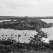
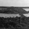
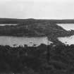
(Area : NF 865 684) A walled islet, connected to the N shore of Loch Scadavay by an S-shaped causeway, lies between the promontories Rudh' a'Chlachain and Ard Smeilish.
There are indications of a gateway a little east from the landing point of the causeway, which leads to a guard-chamber built against the inner side of the fort wall. Its walls range in thickness from 2 to 3ft, enclosing an almost rectangular area of approx 6 by 8ft.
Three other round or oval sheiling-type erections are scattered over the island, but near the centre is a more important building with 2ft thick walls enclosing an area about 12ft diameter.
A large semicircle of stones in the loch forms a boat-harbour on the west side of the island.
E Beveridge 1911.
Not located.
Visited by OS (N K B) 14 June 1965.
Field Visit (3 September 1914)
Dwellings and Hut Circles, Loch Scadavay.
In one of the eastern arms of Loch Scadavay, between Ard Smeilish and Rudh a'Chlachain, some 3 miles west of Lochmaddy, is an islet about 36 yards in length from east to west, and 30 yards in breadth, the western portion rising abruptly to a height of about 10 feet above the loch, and the eastern part about 3 feet. The island towards its western side is connected with a narrow peninsula to the north by a causeway, 60 feet long and from 4 feet 6 inches to 5 feet broad, with a slight double curve in its course.
About 10 feet from the island end of the causeway towards the east and about 4 feet higher is a stone building curved at the eastern end and straight across the opposite end, measuring internally 8 feet from east to west and 6 feet from north to south, the wall, 2 feet thick at the base, standing to a height of from 3 feet to 3 feet 6 inches above the interior, except towards the north-east, where it is broken down. There is a doorway 1 foot 6 inches wide in the southern wall, and another, with the east jamb broken down, in the north wall facing the loch. A recess 14 inches square and 18 inches deep is built in the eastern end. Some 6 feet to the south-south-west and at a slightly higher level is a somewhat similar structure, measuring internally 8 feet from north to south and 5 feet from east to west. As in the first building there is a doorway in each flank, that on the west 1 foot 6 inches wide and the other on the east I foot 10 inches wide; there is also a broken-down recess in the southern end. The wall is from 1 foot 6 inches to 2 feet high. In the same line as these buildings, about 19 feet to the south and on the highest point on the island, is a slightly oval stone structure, 6 feet in length internally from north to south and 5 feet in breadth.
On the flat part of the island near its centre are two more hut circles; the first, lying at about 11 feet east-south-east of the first-mentioned building, is pear-shaped, the broad end to the north, and measures 7 feet from north to south and 6 feet across the widest part, the broken down doorway being in this end. Immediately adjoining it to the south are the remains of the last hut circle; the eastern half has almost disappeared, but the western arc is from 1 foot to 2 feet in height; it has had an internal diameter of about 9 feet.
In shallow water about 12 to 15 feet from the western edge of the island is an irregular setting of large blocks of stone, many projecting above the water, which encloses a crescentic space about 10 yards long, as if to form a rude boat harbour. It has a wide opening towards the south and a narrow opening towards the north.
RCAHMS 1928, visited 3 September 1914.
OS map: North Uist xxxv (unnoted).
Note (4 September 2020)
An islet which appears to match the description is visible on vertical aerial photographs at NF 8713 6835.
Information from HES (GFG) 4 September 2020.

