
Unknown: Ardullie Point, Cromarty Firth


Craft (Period Unassigned)
Site Name Unknown: Ardullie Point, Cromarty Firth
Classification Craft (Period Unassigned)
Alternative Name(s) Ardullie Point Ship Graveyard; Firth Of Cromarty; Unknown
Canmore ID 102038
Site Number NH56SE 8001
NGR NH 58827 62282
Datum WGS84 - Lat/Long
Permalink http://canmore.org.uk/site/102038


- Council Highland
- Parish Maritime - Highland
- Former Region Highland
- Former District Maritime
- Former County Not Applicable
NH56SE 8001 5882 6228
N57 37.7167 W4 21.8667
NLO: Ardullie Point [name: NH 588 622]
Cromarty Firth [name centred NH 69 67].
See also NH56SE 8003.
Formerly entered as Site no. 8550.
Horizontal Datum = OGB
Surveying Details
-----------------------------
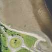
22 June 1973. There is possible obstruction, consisting of debris on beach, which could possibly be part of stranded wreck.
Report taken from aerial photographic evidence.
3 February 1976. This is a stranded wreck which dries to reveal 3.0 metres.
Report by HMS EGERIA, dated 19 January 1976.
21 October 1986. The site's existence is confirmed.
Report by Andrews Hydrographics Ltd.
Hydrographic Office, 1995.
Two locations are marked on the map (NH 591 625 and NH 588 623) as two abandoned herring boats.
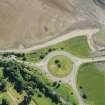
NH 588 623 - The hulk nearer the A9 roundabout and bridge over the Cromarty Firth. To the East of bridge causeway, on North shoreline.
CFA/MORA Coastal Assessment Survey 1998.
Unknown: [no further information].
(Location of loss cited as N57 37.72 W4 21.87).
I G Whittaker 1998.
[No NGR cited]. Ardullie Point, Cromarty Forth, ship graveyard. The remains of two vessels [presumably NH56SE 8001 and possibly NH56SE 8002 or 8003] have been located close to the point on the N side of the Firth adjacent to the A9 road bridge [Cromarty Bridge: NH56SE 37].
An intriguing aspect of this site is the large quantity of carvings and ship graffiti on the trees forming part of the designed landscape of Foulis Castle (NH56SE 2).
Initial research with local museum sources and contact with Mr Hector Munro of Foulis Castle reveals that these hulks are the remains of the local fishing fleet which was laid up during World War I. An initial survey and recording of the hulks and graffiti was carried out in 1995 by Highland Council Archaeology Service.
NMRS, MS/829/21.
Vertical air photography (FCC 7343/32/777-9, flown 17 May 1975) has recorded the outline of a probable shipwreck at NH c. 5881 6224, to the NE of the roundabout and close to the shore.
Information from RCAHMS (RJCM), 28 November 2000.
Reference (2011)
Whittaker ID : 2278
Name : UNKNOWN
Latitude : 573743
Longitude : 42152
Position : Exact Position
Reference (19 April 2012)
UKHO Identifier : 002037
Feature Class : Wreck
Wreck Category : Wreck showing any portion of hull or superstructure
State : LIVE
Classification : Unclassified
Position (Lat/long) : 57.62832,-4.36578
Horizontal Datum : ETRS 1989
WGS84 Position (Lat/long) : 57.62832,-4.36578
WGS84 Origin : Undefined
Previous Position : 57.62862,-4.36445
Position Method : Air photography
Position Quality : Precisely known
Drying Height : 3.0
Depth Quality : Least depth known
Water Depth : -2
Water Level Effect : Covers and uncovers
Vertical Datum : Mean Low Water Springs
Name : UNKNOWN
Bottom Texture : Sand
Contact Description : Entire wreck
Original Sensor : Video Sensor
Last Sensor : Video Sensor
Original Detection Year : 1973
Last Detection Year : 1986
Original Source : Other
Last Source : Survey Vessel
Surveying Details : **H1270/73 22.6.73 POSSIBLE OBSTN OR DEBRIS ON BEACH SHOWN IN 573743N, 042152W, POSSIBLY PART OF NEARLY STRANDED WK ON PHOTOPLOT, PG1355 LPI DTD 30.6.72. INS AS OBSTN. NC 1890.
**H3965/75 3.2.76 THIS IS A STRANDED WRECK AND DRIES 3.0MTRS. (HMS EGERIA, HI 82/75). AMEND TO ST DRIES 3MTRS. NC 1890.
**H3817/86 21.10.86 EXISTENCE CONFIRMED. (ANDREWS HYDRO LTD, SURVEY [K 9893]).
POSITIONS BELOW THIS POINT ARE IN DEGREES, MINUTES AND DECIMALS OF A MINUTE
**11.10.03 EUT POSN: 5737.699N, 0421.947W. NE 1890.
Chart Symbol : ST D3.0
Date Last Amended : 11/10/2003
Date Position Last Amended : 11/10/2003

