
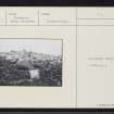
North Uist, Geirisclett


Chambered Cairn (Neolithic), Cremation (Neolithic), Inhumation (Neolithic), Beaker (Pottery)(Bronze Age), Hammerstone (Neolithic), Scraper (Tool) (Flint)(Neolithic), Unidentified Pottery (Pottery)(Neolithic)
Site Name North Uist, Geirisclett
Classification Chambered Cairn (Neolithic), Cremation (Neolithic), Inhumation (Neolithic), Beaker (Pottery)(Bronze Age), Hammerstone (Neolithic), Scraper (Tool) (Flint)(Neolithic), Unidentified Pottery (Pottery)(Neolithic)
Canmore ID 10033
Site Number NF77NE 15
NGR NF 76833 75205
Datum OSGB36 - NGR
Permalink http://canmore.org.uk/site/10033


- Council Western Isles
- Parish North Uist
- Former Region Western Isles Islands Area
- Former District Western Isles
- Former County Inverness-shire
NF77NE 15 7684 7520
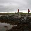
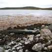
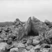
(NF 7684 7520) - Chambered cairn or long cist lying upon Geirisclett, almost exactly at high-water-mark on the extremity of a small point. It was investigated by Beveridge who found three of its sides intact but the east end entirely lost. At that point there were slight indications of a narrow passage bending towards the south. Part of a fallen capstone was found at the western end and what appeared to be the main capstone a few yards away. The chamber was paved throughout.
Finds included fragments of pottery, a flint scraper and a broken hammerstone. (E Beveridge 1911)
The site was visited by Miss Henshall in 1962, when the cairn was found to be considerably robbed and disturbed: on the south side stones have been built into a rough breakwater projecting from the cairn to make a sheltered landing-place. (Information from MS, A S Hensall [Chambered Tombs of Scotland, Vol. 2])
The finds are in the National Museum of Antiquities of Scotland (NMAS).
E Beveridge 1911; Proc Soc Antiq Scot 1912.
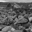
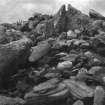
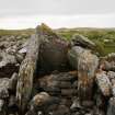
The remains of this much-robbed cairn are generally as described and planned by Henshall.
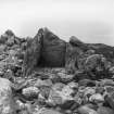
The chamber is in a good state of preservation. To the east of the chamber, on the high-water-line, is the probable capstone, with another large stone to its north.
Surveyed at 1/10,560.
Visited by OS (W D J), 21 June 1965.
NF 7684 7520 A trial excavation was conducted, by the author in association with CFA, in the chamber of this Neolithic tomb which had been previously investigated by Erskine Beveridge in the first decade of this century (NF77NE 15). The chamber lies at HWM and is highly vulnerable to tidal erosion and scouring.
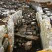
Excavations revealed an inner and outer chamber divided by a substantial threshold slab. The inner chamber was neatly paved, as Beveridge had suggested, and also incorporated a hearth in its NW corner. Further excavation, in a 1 x 1m area where there was no paving, revealed underlying and apparently undisturbed deposits, the earliest of which was a dark silty material banked up against the sides of the chamber.
Paving in the outer chamber had been all but removed by scouring, apparently since Beveridge's time, revealing a partial lower paving of small stones and a post-hole containing two sherds of Neolithic pottery (Hebridean Ware), probably residual.
The paving and associated features in both chambers appear to date to a period after the removal of the tomb's capstones, possibly in the Bronze Age or later, and may relate to secondary buildings built into the body of the cairn. The excavations have, however, demonstrated the survival of earlier deposits and artefactual remains at risk from further erosion and scouring.
Sponsor: Historic Scotland
I Armit 1996.
NF 7684 7520 Further excavations were conducted during May 1997 at the Neolithic chambered tomb of Geirisclett (NMRS NF77NE 15). Trial excavations in 1996 (Armit 1996) had demonstrated that primary tomb deposits in the burial chamber and passage areas had survived previous investigations c 1900-10 by Erskine Beveridge, but that these were now under threat of scouring by tidal action. The 1997 season was designed to excavate fully any deposits surviving in the burial chamber and passage areas in advance of their destruction. The structure of the cairn was not examined as it is not considered to be at risk in the medium term.
The burial chamber is an open-ended rectangle, 2.7 x 1.4m, and is divided into two compartments by upright sill stones c 0.5m high. Its walls are defined by five large orthostats, 1.15-2m high. The passage leading to the chamber is c 2.1m long and of uncertain width, and the kerb of the cairn was traced running in a gentle arc to the N from the passage for c 4.5m.
The inner compartment of the burial chamber contained a sequence of fills which can be divided into four units - patches of a primary floor, in situ secondary fills, disturbed secondary fills, and tertiary paving associated with hearths. It was these tertiary levels which Beveridge had exposed in his excavation at the site early this century. The outer compartment contained two distinct fills, both containing patches of paving, again sealed beneath a layer of paving exposed by Beveridge. There was no definite evidence of in situ burial deposits in this compartment. Very few deposits had survived tidal scouring in the passage area; only a patch of rough paving with a probable post-hole cut through it was encountered.
The finds comprise mainly pottery, cremated bone, and quartz. The pottery derived from at least 11 vessels in a variety of Hebridean Neolithic forms as well as a sherd from a beaker. Sherds from individual vessels were found in some cases at a variety of levels across the burial compartments, suggesting some degree of disturbance of burial deposits in antiquity. The presence of both cremated and inhumed bone reflects variations in the burial rite practised. Quartz lumps and flakes, and the occasional flint flake, were found throughout the burial compartments, and must have been deliberately introduced. No finds were recovered from the passage area. Soil samples have been taken with a view to conducting macrofossil, pollen, and soil micromorphological analyses.
Sponsor: Historic Scotland
A J Dunwell 1997.
This chambered cairn is situated at the present high water mark where it is still susceptible to tidal movement and erosion. The cairn is largely as described by Henshall and it remains unclear whether the large prostrate slab at the SW side of the chamber entrance was a portal stone or an upright of a facade. Excavation of the chamber and its floor deposits in 1997 revealed that it was divided into two compartments by upright sill stones 0.5m high, and presumably these stones equate with those shown on Henshall’s plan and described in the accompanying account as ‘two small stones placed across the chamber floor’ (page 516). However, Beveridge’s photographs of the chamber taken in 1908 do not appear to show these stones and indeed the interior appears relatively stone free. This suggests that Beveridge’s photographs were taken after he had cleared the chamber of ‘the accumulated rubbish’, and raises the possibility that he introduced the sill stones, perhaps in an attempt to stabilise the sides of the chamber and minimise further tidal erosion.
Visited by RCAHMS (ARG, SPH), 31 August 2009.
Field Visit (20 July 1914)
Chambered Cairn, Geirisclett.
On the high-water mark at the extremity of a small promontory on the eastern side of Geirisclett, the peninsula at the north-western corner of Vallay Strand, is a denuded chambered cairn with the ruins of more recent buildings on its summit. The chamber, roughly oblong in plan, which measures about 10 feet 3 inches in length and varies in width from 3 feet 7 inches at the western end to 4 feet 6 inches in the centre and 3 feet at the open eastern end, is formed by five large slabs set on edge, two on each of the north and south sides, and one at the inner end. Its main axis lies nearly east-north-east and west-south-west. The end slab and the one adjoining it on the south side stand 5 feet 4 inches and 5 feet in height respectively, while the other three slabs only attain a height of from 2 feet 3 inches to 2 feet 10 inches. The space intervening between the top of these lower slabs and the roof of the chamber has been filled by drystone building, a small portion composed of small blocks of stone remaining in position above the western slab on the north side. The floor has been paved throughout. Some 4 feet 8 inches from the back of the chamber the top of a slab, 2 feet 10 inches long and 9 inches thick, set on edge across the chamber appears just above the floor, and a somewhat similar but shorter slab is seen at the entrance to the chamber. Among the stones on the beach, under high-water mark, a regularly laid line of small blocks, apparently the outer limit of the cairn, can be traced for some distance round the east towards the north, at a distance varying from 7 feet 8 inches opposite the entrance chamber to about 20 feet opposite the northern wall of the chamber. From the outer curb there are slight indications of a narrow entrance passage running into the chamber. Several large slabs lie on the beach on the eastern slope of the cairn, notably one of roughly triangular shape measuring 12 feet 9 inches in length and 4 feet at its greatest width, which is deposited 3 feet 6 inches from the open end of the chamber; another several feet to the north is 6 feet in length, and a third projecting over the northern wall of the chamber is 3 feet 7 inches long.
About 30 yards west of the cairn are two large slabs embedded in the ground about 10 feet in length by 2 feet 8 inches in breadth and 5 feet in length by 3 feet 1 inch in breadth respectively.
The highest part of the mound in its present dilapidated state is only 6 feet above high-watermark, and at high tides the water laps the chamber.
The chamber was cleared by Mr Beveridge, when several pieces of ornamented pottery, two vessels being represented, a flint scraper and a broken hammer stone, were found.
RCAHMS 1928, visited 20 July 1914
OS map: North Uist xxx (unnoted).
Field Visit (31 August 2009)
This chambered cairn is situated at the present high water mark where it is still susceptible to tidal movement and erosion. The cairn is largely as described by Henshall and it remains unclear whether the large prostrate slab at the SW side of the chamber entrance was a portal stone or an upright of a facade. Excavation of the chamber and its floor deposits in 1997 revealed that it was divided into two compartments by upright sill stones 0.5m high, and presumably these stones equate with those shown on Henshall’s plan and described in the accompanying account as ‘two small stones placed across the chamber floor’ (page 516). However, Beveridge’s photographs of the chamber taken in 1908 do not appear to show these stones and indeed the interior appears relatively stone free. This suggests that Beveridge’s photographs were taken after he had cleared the chamber of ‘the accumulated rubbish’, and raises the possibility that he introduced the sill stones, perhaps in an attempt to stabilise the sides of the chamber and minimise further tidal erosion.
Visited by RCAHMS (ARG,SPH) 31 August 2009
Note (2020)
Geirisclett
This burial site in Western Isles was a focus for funerary practices in the Neolithic/Bronze Age period, between 4000 BC and 2201 BC.
Prehistoric Grave Goods project site ID: 60104
CANMORE ID: 10033
Total no. graves with grave goods: 1
Total no. people with grave goods: 1
Total no. grave goods: 3
Prehistoric Grave Goods project Grave ID: 60035
Grave type: Pit
Burial type(s): Cremation
Grave good: Pot
Materials used: Pottery
Current museum location: Unknown
Grave good: Hammerstone
Materials used: Stone (Uncertain/Unspecified)
Current museum location: Unknown
Grave good: Scraper
Materials used: Chert / Flint [Flint]
Current museum location: Unknown
Further details, the full project database and downloads of project publications can be found here: https://doi.org/10.5284/1052206
An accessible visualisation of the database can be found here: http://blogs.reading.ac.uk/grave-goods/map/

