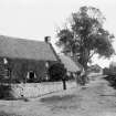
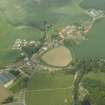
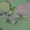
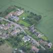
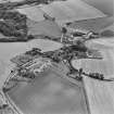
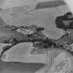
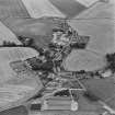
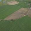
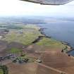
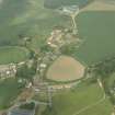
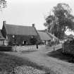
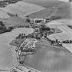
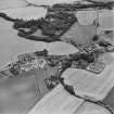
Accessibility

Font Size

100% 150% 200%

Background Colour

Default Contrast
Close Reset

Boarhills, General

Village (Period Unassigned)

Site Name Boarhills, General

Classification Village (Period Unassigned)

Canmore ID 100267

Site Number NO51SE 65

NGR NO 5646 1408

NGR Description Centred NO 5646 1408

Datum OSGB36 - NGR

Permalink http://canmore.org.uk/site/100267

Ordnance Survey licence number AC0000807262. All rights reserved.
Canmore Disclaimer. © Bluesky International Limited 2025. Public Sector Viewing Terms

Toggle Aerial | View on large map

Digital Images

Boarhills.
General view.
Boarhills.
General view.
General oblique aerial view of the village, taken from the SSE.Oblique aerial view.Oblique aerial view.Oblique aerial view centred on Boarhills village with dovecot adjacent, taken from the N.Oblique aerial view centred on Boarhills village taken from the W.Oblique aerial view centred on Boarhills village taken from the SSW.General oblique aerial view centred on the soilmarks of the possible enclosure and rig, and the remains of the church and churchyard, taken from the S.General oblique aerial view of The Kittocks and The Torrance Golf Courses at the Fairmont St Andrews Hotel, with the village of Boarhills to the foreground, taken from the ESE.General oblique aerial view of the village, taken from the SSW.Boarhills.
General view.Oblique aerial view centred on Boarhills village with chapel and dovecot adjacent, taken from the NNW.Oblique aerial view centred on Boarhills village with dovecot adjacent, taken from the NW.

Administrative Areas

  • Council Fife
  • Parish St Andrews And St Leonards
  • Former Region Fife
  • Former District North East Fife
  • Former County Fife

Archaeology Notes

NO51SE 65 centred 5646 1408

References

MyCanmore Image Contributions


Contribute an Image

MyCanmore Text Contributions