
North Uist, Baleshare, Carnan Nan Long


Chambered Cairn (Neolithic)
Site Name North Uist, Baleshare, Carnan Nan Long
Classification Chambered Cairn (Neolithic)
Canmore ID 10005
Site Number NF76SE 15
NGR NF 79057 63670
Datum OSGB36 - NGR
Permalink http://canmore.org.uk/site/10005


- Council Western Isles
- Parish North Uist
- Former Region Western Isles Islands Area
- Former District Western Isles
- Former County Inverness-shire
NF76SE 15 7907 6367.
(NF 7907 6367) Carnan nan Long (NAT)
OS 6"map, Inverness-shire, 2nd ed., (1904)
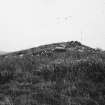
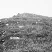
Carnan nan Long is a mound, above the shore, about 40ft in diameter and 10ft high with indications of a chamber c. 15ft by 4ft. On the west of its summit are two large stone slabs. (E Beveridge 1911)
Henshall gives the dimensions as c. 110ft long, 64ft wide at the N end and 32ft at the S, the height agreeing with Beveridge. It is oriented NNE to SSW (bearing 198). Vague foundations of a building are apparent at the NW corner while the NE corner has been eroded by the sea.
E Beveridge 1911; A S Henshall 1972.
The remains of a much mutilated cairn are generally as described by Henshall except for the overall dimensions (c. 26m long by 20m wide). There are only slight indications of a chamber although one orthostat remains in situ. Surveyed at 1/2500. One OS photo.
Visited by OS (JTT) 30 May 1965.
Field Visit (7 September 1914)
Cairn, Carnan nan Long, Baleshare.
At Carnan nan Long, the north-east corner of the island of Baleshare, on the sea-shore and 10 feet above high-water mark, are the remains of a cairn overgrown with grass, measuring some 40 feet in diameter and 5 feet in height. To the west of the summit is an oval hollow, presumably the position of a cist or chamber. On either edge of the hollow are two large slabs 7 feet long, 4 feet 5 inches broad, and 11 inches thick, and 3 feet 10 inches long, 2 feet 8 inches broad, and 8 inches thick respectively, the first slab being suggestive of a cap stone.
RCAHMS 1928, visited 7 September 1914.
OS map: North Uist xxxix.
Field Visit (25 September 2010)
What has evidently been a large cairn is situated immediately above the high water mark on a low headland. Though identified as a long cairn by Henshall, its original shape is difficult to determine, partly because there appear to be later structures built on its NW and S flanks as well as on its summit. Overall the mound is probably roughly circular, measuring roughly 22m across from E to W, but the northern edge is remarkably flat and the presence of the later structures on the S give the impression that cairn material spreads rather further on this axis. A single upright stone protrudes through the cairn material on the S side of the structure built on top of the cairn.
Visited by RCAHMS (SPH) 25 September 2010
Field Visit (2013 - 2014)
Description from RCAHMS Carnan nan Long is a mound, above the shore, about 40ft in diameter and 10ft high with indications of a chamber c. 15ft by 4ft. On the west of its summit are two large stone slabs. Henshall gives the dimensions as c. 110ft long, 64ft wide at the N end and 32ft at the S, the height agreeing with Beveridge. It is oriented NNE to SSW (bearing 198). Vague foundations of a building are apparent at the NW corner while the NE corner has been eroded by the sea.
The remains of a much mutilated cairn are generally as described by Henshall except for the overall dimensions (c. 26m long by 20m wide). There are only slight indications of a chamber although one orthostat remains in situ.
Visited by Scotland's Coastal Heritage at Risk (SCHARP) 2013

