
Pricing Change
New pricing for orders of material from this site will come into place shortly. Charges for supply of digital images, digitisation on demand, prints and licensing will be altered.
Unst, Westing, Kirkaby Church


Broch (Iron Age)(Possible), Burial Ground (Medieval)(Possible), Church (Medieval), Enclosure (Period Unknown), Site (Prehistoric)
Site Name Unst, Westing, Kirkaby Church
Classification Broch (Iron Age)(Possible), Burial Ground (Medieval)(Possible), Church (Medieval), Enclosure (Period Unknown), Site (Prehistoric)
Canmore ID 10
Site Number HP50NE 2
NGR HP 5665 0640
Datum OSGB36 - NGR
Permalink http://canmore.org.uk/site/10


- Council Shetland Islands
- Parish Unst
- Former Region Shetland Islands Area
- Former District Shetland
- Former County Shetland
HP50NE 2 5665 0640
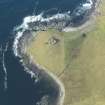
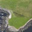
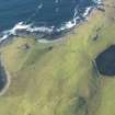
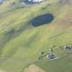
A medieval church within a graveyard, evidently overlying an earlier structure or broch, the vague remains of which are visible to the SE of the graveyard wall. The church comprised a nave and chancel, the former measuring 13' 9" by 12', the latter about 10' by 7', inside walls 2' 9" thick (see Irvine's plan). The entrance was probably in the W end.
D MacGibbon and T Ross 1896-7.
On the highest point of a natural knoll are the turf-covered footings of a church, apparently unicameral, with a rounded E end, within the footings of an enclosure. The church measures 30' E-W by 20' N-S over walls 3 1/2' thick; the enclosure c.86' E-W by 98' N-S over walls built of large stones 3 1/2' thick now overlaid by modern walling on the S, E and part of the N sectors. To the NE of the church at a lower level, there are the footings of a circular structure, 14' internal diameter, which is built out from the enclosure and now overlaid by a modern wall. Its E sector is either destroyed or perhaps never existed. Immediately to the N of the enclosure are the vague traces of one or more indeterminate structures which may be modern or may be part of a graveyard extending northwards for about 25 yards.
A MacDonald Mss Notes, 26 August 1967
The church at HP 5664 0640 is generally as described by MacDonald except that it measures internally c.4.0m in breadth. The wall thickness can no longer be seen, and the E end is greatly mutilated by the later walling so that the length of the church is difficult to determine. There is no trace of the chancel planned by Irvine but this may be due to the mutilation. The surrounding wall, almost certainly delineates a graveyard, about 17.0m across, though no graveslabs remain. The circular structure to the NE of the church is as described by MacDonald and possibly pre-dates the church, but the alleged remains of an earlier 'broch' to the SE of the enclosure wall are no longer in evidence. The remains to the N of the wall, mentioned by MacDonald, are too amorphous to enable classification. Church probably 12th century (information from A MacDonald). Dedication not known.
Surveyed at 1/10,000
Visited by OS (NKB) 8 August 1969.
Publication Account (2002)
HP50 7 KIRKABY
HP/566064.
A possible broch on Unst not noted by the Royal Commission. There are vague traces of a circular structure north-east of the remains of the Medieval church on top of the natural knoll.
Source: OS card HP50 NE 2.
E W MacKie 2002

