Pricing Change
New pricing for orders of material from this site will come into place shortly. Charges for supply of digital images, digitisation on demand, prints and licensing will be altered.
Field Visit


Date 15 August 1943
Event ID 934699
Category Recording
Type Field Visit
Permalink http://canmore.org.uk/event/934699
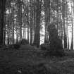
This monument stands at an elevation of nearly 700ft above sea-level, on the spine of a ridge west of the County Asylum. The structure has evidently been greatly disturbed; but the remains of a cist are still recognisable in the east part (Stones K to O) and at the south west corner there is a great pillar (A) 6ft 4in high, 4ft 3in broad and 2ft 11in thick. Of the stones that form the cist, K (2ft 11in high by 2ft 6in broad by 1ft 1in thick) has evidently been badly displaced, but the remainder, which vary from 1ft to 2ft 8in in height, 2ft to 4ft 1in in breadth and 11in to 1ft 6in in thickness, suggest that the cist may have originally measured about 5ft each way and may have had an entrance—perhaps about 1ft 6in broad—on the west side, between Stones K and L. Stone J, an upright 2ft 9in high, 4ft 4in broad and 1ft 6in thick, lacks any obvious function; as do likewise Stones C, E, F and G, which are almost flush with the ground, and stones B and H, which seem to be slabs lying near prone and largely covered up with soil. Stone D, a slab, is lying free, partly on top of Stone C, and has no doubt be[en] thrown into its present position in more or less recent times. (Photo. By Professor Childe).
Visited by RCAHMS (AG, VGC) 15 August 1943.
OS ref: xi ('Stone Circle')