Field Visit


Date 18 June 1998
Event ID 634866
Category Recording
Type Field Visit
Permalink http://canmore.org.uk/event/634866
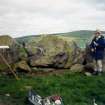
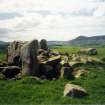
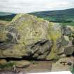
Commanding fine panoramic views, this recumbent stone circle occupies the summit of a hill 470m to the SW of Ardlair farm. It stands upon an old headland in a swath of broad rig-and-furrow cultivation (NJ52NE 28) that was preserved when a wood known as Ardlair Wood was planted on the hill towards the end of the 18th century; the trees were cleared after the 1870s and the area within the plantation boundary has remained in rough pasture ever since. Measuring 11m in diameter, the circle probably comprised nine stones, of which eight remain, the missing stone being on the NNW. Only the recumbent setting and one orthostat on the SW are still upright (8); another orthostat leans steeply (5), two have fallen (6 & 7), and the last lies cut down and displaced on the ESE (4). The recumbent (2), which measures 2.9m in length by 1.65m in height, is a rough block situated on the SSE of the ring, and has a pair of slabs set at right angles to its rear. The fractured character of the block suggests that it has been blasted, leaving the W end shattered and removing the E half of the outer face, though a few of the fragments may yet lie amongst the field-cleared stones gathered around its base. Such was the impact of the blast that only part of the recumbent’s summit remains intact, enough to suggest that it may have been even, but insufficient to confirm whether it was originally horizontal. The blast probably threw the eastern of a pair of support stones forwards, causing that end of the recumbent to slump. Like the recumbent, the W flanker (1), now only 1.5m high, has also lost part of its top, but otherwise the two flankers are of similar size and shape. Both are aligned with the front of the recumbent, but while the W flanker is turned to trace the arc of the circle, the E flanker is not. The latter, and the sole orthostat remaining upright (8), are about 1.7m high, suggesting the circle was graded to reduce in height from the S round to the shorter fallen stones on the N (5 & 6). The circle encloses a low mound of earth and stones measuring 8.5m from NE to SW by 7m transversely and 0.25m in height, though much of this is now obscured by field clearance, especially behind the recumbent setting, where only the upper sections of the pair of slabs set up at its rear are exposed. Both these stones have cupmarks on their upper surfaces, the single cup on the E slab being more visible than the two on the W.
Visited by RCAHMS (ATW and KHJM) 18 June 1998