Ordnance Survey licence number AC0000807262. All rights reserved.
Canmore Disclaimer.
© Copyright and database right 2024.
Event | Type | Subtype | Notes | Date |
---|---|---|---|---|
556015 | RECORDING | EXCAVATION | Excavation of a cropmark barrow cemetery and settlement at Red Castle, Lunan Bay by CFA as part of the Edinburgh University's Angus and South Aberdeenshire Field School. [...] | 1997 |
555974 | RECORDING | EXCAVATION | Excavation of a cropmark site at Ironshill by CFA as part of the Edinburgh University's Angus and South Aberdeenshire Field School. [...] | 1998 |
Excavation photographs: Film 23 from the 1995 season at Brown Caterthun. A length of heavily disturbed and disfigured Rampart F (where Trench 1 was excavated), from the north-east.
Historic Scotland Archive Project
1995
© Historic Scotland
Excavation photographs: Film 62 from the 1996 season at Brown Caterthun. Trench 20, Enclosure A: entrance within palisade enclosure, from the south.
Historic Scotland Archive Project
6/8/1996
© Historic Scotland
Excavation photographs: Film 66 from the 1996 season at Brown Caterthun. Wall B rear face, Trench 17.
Historic Scotland Archive Project
5/8/1996
© Historic Scotland
Excavation photographs: Film 7 from the 1995 season at Brown Caterthun. Wall B front face, Trench 5.
Historic Scotland Archive Project
11/9/1995
© Historic Scotland
Excavation photographs: Film 21 from the 1995 season at Brown Caterthun. Trench 2, Rampart E: burnt timber deposit 6 from the north-east (outer rampart face to left). Note the rabbit burrow running obliquely through the timbers to the left of the small scale.
Historic Scotland Archive Project
15/9/1995
© Historic Scotland
Excavation photographs: Film 91 from the 1996 season at Brown Caterthun. Trench 15, Rampart E: stone face of rampart and cobble alignment beneath rampart, from the south.
Historic Scotland Archive Project
11/9/1996
© Historic Scotland
Excavation photographs: Film 68 from the 1996 season at Brown Caterthun. Trench 14: Rampart F, cobble layer, buried turf and posthole from the north-west.
Historic Scotland Archive Project
5/8/1996
© Historic Scotland
Excavation photographs: Film 68 from the 1996 season at Brown Caterthun. Trench 14: Rampart F and ditch from the east.
Historic Scotland Archive Project
5/8/1996
© Historic Scotland
Excavation photographs: Film 72 from the 1996 season at Brown Caterthun. Trench 12, Rampart F: ditch terminal south of hte entrance, showing large rock-cut posthole in terminal, from the north.
Historic Scotland Archive Project
7/8/1996
© Historic Scotland
Excavation photographs: Film 56 from the 1996 season at Brown Caterthun. 
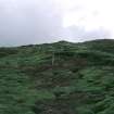
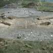
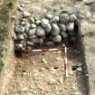
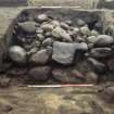
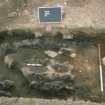
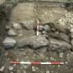
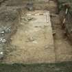
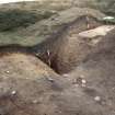
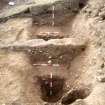
Trench 21: quarry scoop from the north-east. Within the scoop, to the left, the soil is shallow over bedrock; to the right, outside the scoop, the greater depth of soil can be seen in the stepped section. The irregular gully proved to be a natural feature.
Historic Scotland Archive Project
29/7/1996
© Historic Scotland
Excavation archive: Correspondence relating to tender process and acceptance, reports and publication of the excavations at Brown Caterthun.
Post-excavation archive: Radiocarbon application forms and result sheets from 1995 and 1996 excavations at Brown Caterthun.
Post-excavation archive: Specialist reports. Includes –Analysis of soil thin sections from Trenches 15 and 17; Soil thin section analysis; Coarse Pottery; Plan Macrofossil Analysis; Conservation of the iron arrowhead from Brown Caterthun; Iron knife fragment; Carbonise Wood; Carbonised wood studies report (contexts 008 and 058); Report on the on-site palynological analysis; Charcoal identification; Flint report; Coarse Stone Report; Geophysical Survey Report.
© Historic Environment Scotland. Scottish Charity No. SC045925