Pricing Change
New pricing for orders of material from this site will come into place shortly. Charges for supply of digital images, digitisation on demand, prints and licensing will be altered.
Kinlochbervie Wreck Project, Sutherland, Scotland


Date June 2000 - May 2002
Event ID 556629
Category Project
Type Project
Permalink http://canmore.org.uk/event/556629
(Location cited as N58 26.213 W5 6.43: NC 186 540). In May 1997, Mr R Hemming and members of RAF Lossiemouth SAC discovered pottery, anchors and cast-iron guns about 4 miles SW of Kinlochbervie. No ballast, timbers or other structural elements have been recognised but the majolica ware recovered forms the largest assemblage of Italian Renaissance pottery from a Scottish archaeological context.
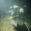
The remains lie on a slope (down to 34m depth) within an exposed area of complex and rocky coastline behind a prominent group of offshore skerries (Sgeirean cruaidhe). The RAF club carried out further exploration between 1997 2000. The remains were accorded statutory protection in 2001, and in the same year the site was visited by the Archaeological Diving Unit and the Time Team programme. Extensive survey work was carried out in 2001 and 2002, artifacts considered at risk from swash damage being raised and passed to the NMS for conservation in the latter year. In 2002, three small trial-pits were excavated within one of the gullies. Sufficient finds were made in one of them to indicate that numerous further artifacts remain undiscovered in other gullies.
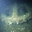
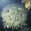
Two distinct areas of deposition have been distinguished. The 'deep area' is the larger, and is situated within an area of medium to low-energy environment on a sloping seabed at the foot of an underwater cliff between 25 and 30m deep. An area of some 320 sq m was searched, within which the major deposit occupied an area of some 170 sq m. Two cast-iron guns and two wrought-iron anchors lie at the foot of the cliff while a third gun lies on a ledge at the cliff-top. Pottery, fragments of brick and a few other finds were discovered in sandy deposits, within rock-crevices, and between boulders. The 'shallow area' is located within a shallow and semi-enclosed 'lagoon' area, within the surf zone and in large part beneath heavy kelp at depths of between 4 and 14m. Random searches have revealed a sounding lead, two-wrought-iron anchors and a cast-iron gun; a further gun remains unverified.
Study of site dynamics within the 'deep area' was carried out in 2002, and comprised visual inspection of pottery sherds, the release of two types of bottom drifter, the emplacement of seabed sediment test stakes, and the analysis of sediment samples. Taken together, these indicated minimal water or seabed movement, allowing the development over time of a reducing microenvironment.
The 191 finds recovered comprise: 147 pieces pottery, 33 pieces of brick and 3 of tile, a metal disc, a small concretion, an unworked flint, a cast-iron and a stone cannon ball, two pieces of lead sheet and a sounding-lead. A further four guns, four anchors, eleven pieces of brick and two pieces of pottery were left in situ. Minute fragments of wood attached to the guns were the only organic material identified.
Gun 1 measured 2.6m in length and was of bore diameter 90mm, possibly identifying it as a sacre or 5-pounder of the late 16th or early 17th centuries. The other guns recovered are obscured by concretion, but were probably manufactured in England or the Baltic countries during the same period. Both the shot pieces recovered conform to this size. The anchors recovered appear to be of two different sizes, and of a design common to the 16th and 17th centuries. They may represent four bower anchors (stowed forward).
In the apparent absence of specific documentary reference, the artifactual evidence of the pottery and guns indicates a terminus post quem of between about 1590 and 1610; attribution to the Armada appears unjustified. The Iberian associations of the brick, tile and pottery suggest that the remains represent the loss of a merchant vessel sailing from Iberia to northern Europe, possibly taking the Atlantic route to avoid piracy in the Narrow Seas.
Within Muckelroy's (1978) criteria, this wreck falls into Class 5, comprising scattered wreckage with no structural remains. The absence of ballast mounds and major hull fittings is surprising, while the preservation of pottery within the 'deep area' may be considered the anomalous result of tumble down the cliff. The remains may represent only the forward portion of the vessel, the remainder lying offshore, at the start of a debris trail
(Corrosion studies by B Kaye and J Cook are reported in detail).
Summary by RCAHMS (RJCM)
Source: P Robertson, B Kaye and J Cook 2004.