
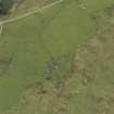
Aerial Photography


Date 3 May 2007
Event ID 546186
Category Recording
Type Aerial Photography
Permalink http://canmore.org.uk/event/546186
Ordnance Survey licence number AC0000807262. All rights reserved.
Canmore Disclaimer.
© Bluesky International Limited 2025.

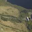
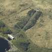
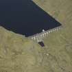
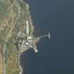
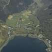
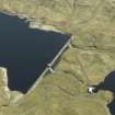
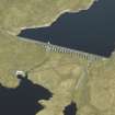
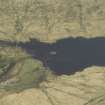
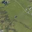
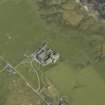
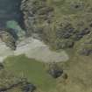
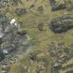
DP 029548
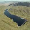
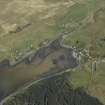
Oblique aerial view centred on the Loch Sloy hydro-electric power station, feeder pipes and valve house, taken from the SSW.
RCAHMS Aerial Photography Digital
3/5/2007
© Crown Copyright: HES

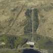
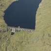
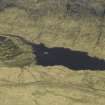
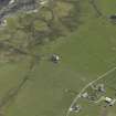
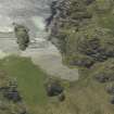
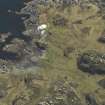
DP 029549
Oblique aerial view centred on Loch Sloy hydroelectric power station, feeder pipes and valve house, taken from the SSW.
RCAHMS Aerial Photography Digital
3/5/2007
© Crown Copyright: HES

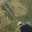
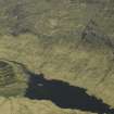
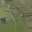
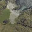
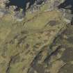
DP 029550
Oblique aerial view centred on the hydro-electric power station, feeder pipes and valve house, taken from the SE.
RCAHMS Aerial Photography Digital
3/5/2007
© Crown Copyright: HES

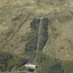
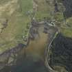
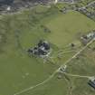
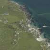
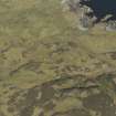
DP 029551
Oblique aerial view of Loch Sloy Hydro-Electric Power Station, centred on the power station, feeder pipes and valve house, taken from the SE.
RCAHMS Aerial Photography Digital
3/5/2007
© Crown Copyright: HES

DP 029552
Oblique aerial view centred on the hydro-electric power station, feeder pipes and valve house, taken from the E.
RCAHMS Aerial Photography Digital
3/5/2007
© Crown Copyright: HES

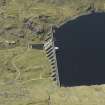
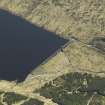
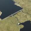
DP 029553
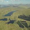
Oblique aerial view centred on the dam, taken from the NE.
RCAHMS Aerial Photography Digital
3/5/2007
© Crown Copyright: HES

DP 029554
Oblique aerial view centred on the dam, taken from the W.
RCAHMS Aerial Photography Digital
3/5/2007
© Crown Copyright: HES

DP 029555
Oblique aerial view centred on the dam, taken from the SW.
RCAHMS Aerial Photography Digital
3/5/2007
© Crown Copyright: HES

DP 029556
Oblique aerial view centred on the dam, taken from the SSE.
RCAHMS Aerial Photography Digital
3/5/2007
© Crown Copyright: HES

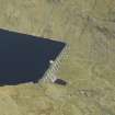
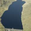
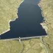
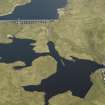
DP 029557
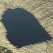
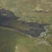
Oblique aerial view of the reservoir and dam, taken from the SE.
RCAHMS Aerial Photography Digital
3/5/2007
© Crown Copyright: HES

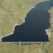
DP 029558
Oblique aerial view centred on the dam, taken from the SE.
RCAHMS Aerial Photography Digital
3/5/2007
© Crown Copyright: HES

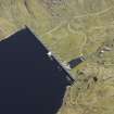
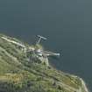
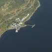
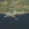
DP 029559
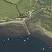
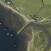
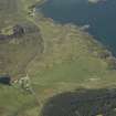
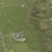
Oblique aerial view centred on the pier and buildings of the Royal Navy Torpedo Testing Station, taken from the NW.
RCAHMS Aerial Photography Digital
3/5/2007
© Crown Copyright: HES

DP 029560
Oblique aerial view centred on the pier and buildings of the Royal Navy Torpedo Station, taken from the SW.
RCAHMS Aerial Photography Digital
3/5/2007
© Crown Copyright: HES

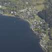
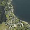
DP 029561
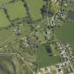
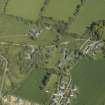
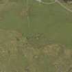
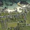
General oblique aerial view of the village, taken from the W.
RCAHMS Aerial Photography Digital
3/5/2007
© Crown Copyright: HES

DP 029562
General oblique aerial view looking along Glen Loin, taken from the SW.
RCAHMS Aerial Photography Digital
3/5/2007
© Crown Copyright: HES

DP 029563
Oblique aerial view centred on the pier and buildings of the Royal Navy Torpedo Station, taken from the SSW.
RCAHMS Aerial Photography Digital
3/5/2007
© Crown Copyright: HES

DP 029564
General oblique aerial view looking along Glen Loin, taken from the SSW.
RCAHMS Aerial Photography Digital
3/5/2007
© Crown Copyright: HES

DP 029565
Oblique aerial view centred on the pier and buildings of the Royal Navy Torpedo Station, taken from the SSE.
RCAHMS Aerial Photography Digital
3/5/2007
© Crown Copyright: HES

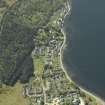
DP 029566
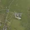
Oblique aerial view centred on the village, taken from the NE.
RCAHMS Aerial Photography Digital
3/5/2007
© Crown Copyright: HES

DP 029567
Oblique aerial view centred on the village, taken from the NE.
RCAHMS Aerial Photography Digital
3/5/2007
© Crown Copyright: HES

DP 029568
General oblique aerial view of the village, taken from the WNW.
RCAHMS Aerial Photography Digital
3/5/2007
© Crown Copyright: HES

DP 029569
General oblique aerial view looking along Glen Loin, taken from the SW.
RCAHMS Aerial Photography Digital
3/5/2007
© Crown Copyright: HES

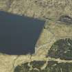
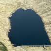
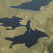
DP 029570
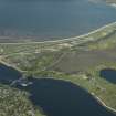
Oblique aerial view centred on the dam and reservoir, taken from the NW.
RCAHMS Aerial Photography Digital
3/5/2007
© Crown Copyright: HES

DP 029571
Oblique aerial view centred on the dam and reservoir, taken from the WNW.
RCAHMS Aerial Photography Digital
3/5/2007
© Crown Copyright: HES

DP 029572
Oblique aerial view centred on the dam and reservoir, taken from the W.
RCAHMS Aerial Photography Digital
3/5/2007
© Crown Copyright: HES

DP 029573
Oblique aerial view centred on the dam and reservoir, taken from the WSW.
RCAHMS Aerial Photography Digital
3/5/2007
© Crown Copyright: HES

DP 029574
Oblique aerial view centred on the dam and reservoir, taken from the WSW.
RCAHMS Aerial Photography Digital
3/5/2007
© Crown Copyright: HES

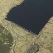
DP 029575
Oblique aerial view centred on the dam and reservoir, taken from the SW.
RCAHMS Aerial Photography Digital
3/5/2007
© Crown Copyright: HES

DP 029576
Oblique aerial view centred on the dam, power station and reservoir, taken from the WNW.
RCAHMS Aerial Photography Digital
3/5/2007
© Crown Copyright: HES

DP 029577
Oblique aerial view centred on the dam, power station and reservoir, taken from the WSW.
RCAHMS Aerial Photography Digital
3/5/2007
© Crown Copyright: HES

DP 029578
Oblique aerial view centred on the dam, power station and reservoir, taken from the SW.
RCAHMS Aerial Photography Digital
3/5/2007
© Crown Copyright: HES

DP 029579
Oblique aerial view centred on the dam, power station and reservoir, taken from the SW.
RCAHMS Aerial Photography Digital
3/5/2007
© Crown Copyright: HES

DP 029580
Oblique aerial view centred on the dam, power station and reservoir, taken from the SW.
RCAHMS Aerial Photography Digital
3/5/2007
© Crown Copyright: HES

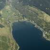
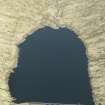
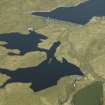
DP 029581
General oblique aerial view centred on the dams, power station and reservoir, taken from the SW.
RCAHMS Aerial Photography Digital
3/5/2007
© Crown Copyright: HES

DP 029582
General oblique aerial view centred on the dams, power station and reservoir, taken from the SSW.
RCAHMS Aerial Photography Digital
3/5/2007
© Crown Copyright: HES

DP 029583
General oblique aerial view centred on the dams, power station and reservoir, taken from the SSW.
RCAHMS Aerial Photography Digital
3/5/2007
© Crown Copyright: HES

DP 029584
General oblique aerial view centred on the dams, power station and reservoir, taken from the WNW.
RCAHMS Aerial Photography Digital
3/5/2007
© Crown Copyright: HES

DP 029585
General oblique aerial view centred on the dams, power station and reservoir, taken from the WSW.
RCAHMS Aerial Photography Digital
3/5/2007
© Crown Copyright: HES

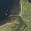
DP 029586
Oblique aerial view centred on the jetty, taken from the NW.
RCAHMS Aerial Photography Digital
3/5/2007
© Crown Copyright: HES

DP 029587
Oblique aerial view centred on the Iron Works, taken from the W.
RCAHMS Aerial Photography Digital
3/5/2007
© Crown Copyright: HES

DP 029588
Oblique aerial view centred on the jetty, taken from the W.
RCAHMS Aerial Photography Digital
3/5/2007
© Crown Copyright: HES

DP 029589
Oblique aerial view centred on the Iron Works, taken from the SW.
RCAHMS Aerial Photography Digital
3/5/2007
© Crown Copyright: HES

DP 029590
Oblique aerial view centred on the jetty, taken from the SSW.
RCAHMS Aerial Photography Digital
3/5/2007
© Crown Copyright: HES

DP 029591
Oblique aerial view centred on the Iron Works, taken from the S.
RCAHMS Aerial Photography Digital
3/5/2007
© Crown Copyright: HES

DP 029592
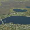
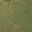
General oblique aerial view looking across the bridge, village, the Falls of Lora and an 'SNP' banner towards the Moss of Achnacree, taken from the SSW.
RCAHMS Aerial Photography Digital
3/5/2007
© Crown Copyright: HES

DP 029593
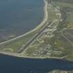
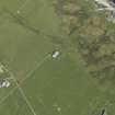
Oblique aerial view centred on the airfield, taken from the SSE.
RCAHMS Aerial Photography Digital
3/5/2007
© Crown Copyright: HES

DP 029594
General oblique aerial view looking across the bridge, village, the Falls of Lora and an 'SNP' banner towards the Moss of Achnacree, taken from the SE.
RCAHMS Aerial Photography Digital
3/5/2007
© Crown Copyright: HES

DP 029595
General oblique aerial view looking across the bridge, airfield, village, the Falls of Lora and an 'SNP' banner, taken from the SSW.
RCAHMS Aerial Photography Digital
3/5/2007
© Crown Copyright: HES

DP 029596
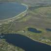
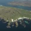
Oblique aerial view centred on the remains of the fortified island, taken from the NW.
RCAHMS Aerial Photography Digital
3/5/2007
© Crown Copyright: HES

DP 029597
Oblique aerial view centred on the remains of the fortified island, taken from the NW.
RCAHMS Aerial Photography Digital
3/5/2007
© Crown Copyright: HES

DP 029598
Oblique aerial view centred on the remains of the fortified island, taken from the WNW.
RCAHMS Aerial Photography Digital
3/5/2007
© Crown Copyright: HES

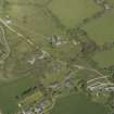
DP 029599
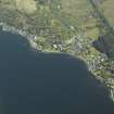
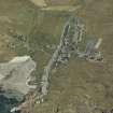
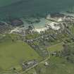
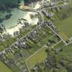
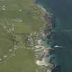
General oblique aerial view centred on the village, taken from the NW.
RCAHMS Aerial Photography Digital
3/5/2007
© Crown Copyright: HES

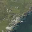
DP 029600
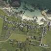
General oblique aerial view centred on the village, taken from the WSW.
RCAHMS Aerial Photography Digital
3/5/2007
© Crown Copyright: HES

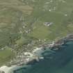
DP 029601
General oblique aerial view centred on the village, taken from the SSW.
RCAHMS Aerial Photography Digital
3/5/2007
© Crown Copyright: HES

DP 029602
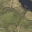
General oblique aerial view of the remains of the cairn and township, taken from the SE.
RCAHMS Aerial Photography Digital
3/5/2007
© Crown Copyright: HES

DP 029603
Oblique aerial view centred on the remains of the cairn and township, taken from the NNE.
RCAHMS Aerial Photography Digital
3/5/2007
© Crown Copyright: HES

DP 029604
Oblique aerial view centred on the remains of the cairn and township, taken from the NW.
RCAHMS Aerial Photography Digital
3/5/2007
© Crown Copyright: HES

DP 029605
Oblique aerial view centred on the remains of the cairn and township, taken from the W.
RCAHMS Aerial Photography Digital
3/5/2007
© Crown Copyright: HES

DP 029606
Oblique aerial view centred on the remains of the cairn and township, taken from the SW.
RCAHMS Aerial Photography Digital
3/5/2007
© Crown Copyright: HES

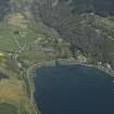
DP 029607
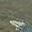
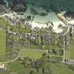
General oblique aerial view of the village and jetty, taken from the NNW.
RCAHMS Aerial Photography Digital
3/5/2007
© Crown Copyright: HES

DP 029608
General oblique aerial view of the village and jetty, taken from the NW.
RCAHMS Aerial Photography Digital
3/5/2007
© Crown Copyright: HES

DP 029609
General oblique aerial view of the village and jetty, taken from the WNW.
RCAHMS Aerial Photography Digital
3/5/2007
© Crown Copyright: HES

DP 029610
General oblique aerial view of the village and jetty, taken from the WNW.
RCAHMS Aerial Photography Digital
3/5/2007
© Crown Copyright: HES

DP 029611
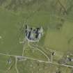
Oblique aerial view centred on the abbey and the remains of the vallum, taken from the NE.
RCAHMS Aerial Photography Digital
3/5/2007
© Crown Copyright: HES

DP 029612
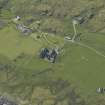
Oblique aerial view centred on the house and the remains of the vallum, taken from the NE.
RCAHMS Aerial Photography Digital
3/5/2007
© Crown Copyright: HES

DP 029613
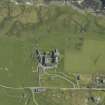
Oblique aerial view of the abbey, the Macleod Centre and the remains of the vallum, taken from the NNE.
RCAHMS Aerial Photography Digital
3/5/2007
© Crown Copyright: HES

DP 029614
Oblique aerial view centred on the house, taken from the N.
RCAHMS Aerial Photography Digital
3/5/2007
© Crown Copyright: HES

DP 029615
Oblique aerial view centred on the abbey, the Macleod Centre and the remains of the vallum, taken from the WNW.
RCAHMS Aerial Photography Digital
3/5/2007
© Crown Copyright: HES

DP 029616
Oblique aerial view of the village and jetty, taken from the NNW.
RCAHMS Aerial Photography Digital
3/5/2007
© Crown Copyright: HES

DP 029617
Oblique aerial view centred on the abbey and the remains of the vallum, taken from the WNW.
RCAHMS Aerial Photography Digital
3/5/2007
© Crown Copyright: HES

DP 029618
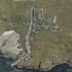
Oblique aerial view centred on the village, taken from the WNW.
RCAHMS Aerial Photography Digital
3/5/2007
© Crown Copyright: HES

DP 029619
Oblique aerial view centred on the village, taken from the W.
RCAHMS Aerial Photography Digital
3/5/2007
© Crown Copyright: HES

DP 029620
Oblique aerial view centred on the abbey and the remains of the vallum, taken from the SW.
RCAHMS Aerial Photography Digital
3/5/2007
© Crown Copyright: HES

DP 029621
Oblique aerial view centred on the abbey and the remains of the vallum with the house adjacent, taken from the SSW.
RCAHMS Aerial Photography Digital
3/5/2007
© Crown Copyright: HES

DP 029622
Oblique aerial view centred on the abbey and the remains of the vallum, taken from the S.
RCAHMS Aerial Photography Digital
3/5/2007
© Crown Copyright: HES

DP 029623
Oblique aerial view centred on the village, taken from the NNW.
RCAHMS Aerial Photography Digital
3/5/2007
© Crown Copyright: HES

DP 029624
Oblique aerial view centred on the village, taken from the NW.
RCAHMS Aerial Photography Digital
3/5/2007
© Crown Copyright: HES

DP 029625
Oblique aerial view centred on the abbey and the remains of the vallum, taken from the W.
RCAHMS Aerial Photography Digital
3/5/2007
© Crown Copyright: HES

DP 029626
Oblique aerial view centred on the house, taken from the SW.
RCAHMS Aerial Photography Digital
3/5/2007
© Crown Copyright: HES

DP 029627
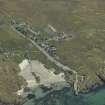
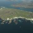
General oblique aerial view of Iona, taken from the WNW.
RCAHMS Aerial Photography Digital
3/5/2007
© Crown Copyright: HES

DP 029628
General oblique aerial view of Iona, taken from the WNW.
RCAHMS Aerial Photography Digital
3/5/2007
© Crown Copyright: HES

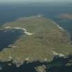
DP 029629
General oblique aerial view of Iona, taken from the WNW.
RCAHMS Aerial Photography Digital
3/5/2007
© Crown Copyright: HES

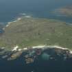
DP 029630
General oblique aerial view of Iona, taken from the SW.
RCAHMS Aerial Photography Digital
3/5/2007
© Crown Copyright: HES

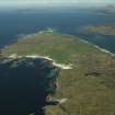
DP 029631
General oblique aerial view of Iona, taken from the SW.
RCAHMS Aerial Photography Digital
3/5/2007
© Crown Copyright: HES

DP 029632
Oblique aerial view centred on the remains of the cairns, taken from the E.
RCAHMS Aerial Photography Digital
3/5/2007
© Crown Copyright: HES

DP 029633
Oblique aerial view centred on the remains of the cairns, taken from the NE.
RCAHMS Aerial Photography Digital
3/5/2007
© Crown Copyright: HES

DP 029634
Oblique aerial view centred on the remains of the cairns, taken from the NNE.
RCAHMS Aerial Photography Digital
3/5/2007
© Crown Copyright: HES

DP 029635
General oblique aerial view of the abbey and village, taken from the SSW.
RCAHMS Aerial Photography Digital
3/5/2007
© Crown Copyright: HES

DP 029636
General oblique aerial view of the abbey and village, taken from the SSW.
RCAHMS Aerial Photography Digital
3/5/2007
© Crown Copyright: HES

DP 029637
General oblique aerial view of the abbey and village, taken from the SSW.
RCAHMS Aerial Photography Digital
3/5/2007
© Crown Copyright: HES

DP 029638
General oblique aerial view of the abbey and village, taken from the S.
RCAHMS Aerial Photography Digital
3/5/2007
© Crown Copyright: HES

DP 029639
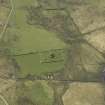
Oblique aerial view centred on the remains of the township, taken from the SE.
RCAHMS Aerial Photography Digital
3/5/2007
© Crown Copyright: HES

DP 029640
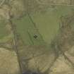
Oblique aerial view centred on the remains of the farmstead, taken from the NNE.
RCAHMS Aerial Photography Digital
3/5/2007
© Crown Copyright: HES

DP 029641
Oblique aerial view centred on the remains of the farmstead, taken from the N.
RCAHMS Aerial Photography Digital
3/5/2007
© Crown Copyright: HES

DP 029642
Oblique aerial view centred on the remains of the farmstead, taken from the NW.
RCAHMS Aerial Photography Digital
3/5/2007
© Crown Copyright: HES

DP 029643
Oblique aerial view centred on the remains of the farmstead, taken from the W.
RCAHMS Aerial Photography Digital
3/5/2007
© Crown Copyright: HES

DP 029644
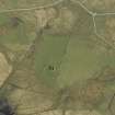
Oblique aerial view centred on the remains of the church and the burial ground, taken from the E.
RCAHMS Aerial Photography Digital
3/5/2007
© Crown Copyright: HES

DP 029645
Oblique aerial view centred on the remains of the church and the burial ground, taken from the NE.
RCAHMS Aerial Photography Digital
3/5/2007
© Crown Copyright: HES

DP 029646
Oblique aerial view centred on the remains of the church and the burial ground, taken from the NW.
RCAHMS Aerial Photography Digital
3/5/2007
© Crown Copyright: HES

DP 029647
Oblique aerial view centred on the remains of the church and the burial ground, taken from the W.
RCAHMS Aerial Photography Digital
3/5/2007
© Crown Copyright: HES
First 100 images shown.

Oblique aerial view centred on the Loch Sloy hydro-electric power station, feeder pipes and valve house, taken from the SSW.
Oblique aerial view centred on Loch Sloy hydroelectric power station, feeder pipes and valve house, taken from the SSW.
Oblique aerial view centred on the hydro-electric power station, feeder pipes and valve house, taken from the SE.
