Field Visit


Date June 1967
Event ID 1174849
Category Recording
Type Field Visit
Permalink http://canmore.org.uk/event/1174849
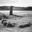
NM 907 289. Situated in pasture 450 m S of Strontoiller farmhouse on the flood -plain at the N end of Loch Nell, this cairn and its associated standing stone (Pl. 9A) are 185 m SSE of the stone circle No. 120. The cairn was excavated in 1967 and the following account is a summary of the published report (GAJ, ii (1971), 1-7).
Approximately circular on plan (Fig. 26), and measuring some 4' 5 m in overall diameter, it has been kerbed by fifteen large boulders, twelve of which survive. All but one of the kerb-stones are granite erratics, measuring up to 1'3 m in height on the S side and apparently decreasing in size on the N. Excavation revealed that white quartz chips had been deliberately placed round the bases of the kerb-stones. The cairn material, composed of earth, gravel and stones, was lower than the surrounding kerb, standing to a height of only 0'75 m above the natural ground-level, and it is unlikely that it was originally of greater height. On the old land-surface there was a layer of burning and an unexplained hollow (‘b’ on Fig. 26),while in the basal layer of cairn material a very small quantity of cremated bone was discovered. An intrusive pit (‘a’ on Fig. 26) was the result of an earlier excavation (PSAS, x (1872-4), 84-5). For further discussion of this class of cairn see RCAHMS 1975 p. 10.
RCAHMS 1975, visited June 1967.