Pricing Change
New pricing for orders of material from this site will come into place shortly. Charges for supply of digital images, digitisation on demand, prints and licensing will be altered.
Measured Survey


Date 14 August 1991 - 13 August 1993
Event ID 1148886
Category Recording
Type Measured Survey
Permalink http://canmore.org.uk/event/1148886
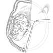
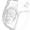
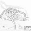
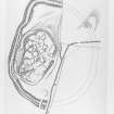
RCAHMS surveyed the fort at Bailiehill between 14-16 August 1991 and 11-13 August 1993 with plane-table and self-reducing alidade at a scale of 1:500. The plan was redrawn in ink and published at a scale of 1:1000 (RCAHMS 1997, Fig. 74).