Field Visit


Date 16 July 1912
Event ID 1133035
Category Recording
Type Field Visit
Permalink http://canmore.org.uk/event/1133035
Roman Camp, Gilnockie.
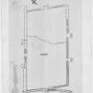
Immediately in rear of the farm cottages at New Woodhead, and about ½ mile due north of Gilnockie railway station, is a large rectangular oblong enclosure with rounded angles, lying partly on grass land and partly within a wood, which presents characteristics of Roman castrametation (fig. 28). The site is a plateau rising gently on all sides to an elevation of some 390 feet above sea-level, not in itself very prominent or greatly exposed, but commanding an extensive prospect over a wide area of country in all directions. The fort lies with its main axis north-east and south-west, and has measured within its defences some 1450 feet by 750 feet, or about 25 acres. It has apparently been surrounded by a single ditch and rampart, the former having now from crest to crest a width of some 18 feet and the latter a breadth at base varying from 20 to 30 feet. Along the north-east end the vallum across the grass field, though much ploughed down, is easily traceable. On the south-east flank from the east angle for a distance of 220 feet it is no longer to be seen; but thereof after across an adjacent meadow through a young plantation and an old wood it can be followed with ease, till it makes a return in a north-westerly direction close to the railway from Riddings Junction to Langholm. With the railway line it gradually converges, and is eventually lost beneath it. On the northwest flank it has been greatly interfered within the formation of a road, ditch, and hedge, which more or less occupy its position, leaving it only partially and intermittently recognisable. On the south-east side, at 520 feet from the east angle, is a well-defined entrance some 72 feet in width, which is covered at ad istance of 36 feet in front by a traverse, a mound 56 feet in length and 22 feet in bread that base at centre, tapering slightly to each end and 3 feet 7 inches in elevation, with a ditch at its base on the outer face. At 126 feet to the north-east of this entrance is a gap in the vallum 10 feet wide, which, if not original, does not seem to be modern. At 400 feet further to the southward, and 478 feet from the south angle, is another entrance 40 feet wide, which is likewise covered 30 feet in front by a traverse 50 feet long and 33 feet broad at the centre, tapering slightly to either end and 3 feet 6 inches in elevation. Any entrance which may have formerly existed through the south-west end does not seem now to be recognisable, the rampart being destroyed at a number of places and the ditch much filled in. Near the centre of the north-east end, immediately in rear of the cottages, a slight break is apparent in the rampart; and some 25 feet in front lies a circular area, measuring in diameter some 33 feet by 27 feet, on which the vegetation is markedly poorer than elsewhere in its vicinity-a condition which may possibly be due to the former existence of a traverse on the spot, the clay from which has deteriorated the soil. The greatest existing height of the rampart above the ditch is about 5 feet. There are no indications of any foundations in the enceinte; and, though the woodland area has been trenched in all directions for drainage, there is no record or tradition of any traces of buildings having been observed or of relics recovered.
RCAHMS 1920, visited 16 July 1912.