04/08/2020, Scotland's Rock Art Project (ScRAP), Corrimony 2


Event ID 1132716
Category Descriptive Accounts
Type Note
Permalink http://canmore.org.uk/event/1132716
Date fieldwork started: 04/08/2020
Compiled by: NOSAS
ScRAP ID: 3534
Corrimony 2
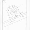
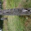
Location notes: This is a standing stone located to the NNW of the Corrimony, a Clava type cairn. The cairn is a 'Property in Care' and monitored by Historic Environment Scotland and regularly visited by the public. The standing stone is situated immediately to the NNW of the minor road to Corrimony on the flat ground about 220m S of the River Enrick. The cairn and associated standing stones are enclosed by a metal fence and approached across a footbridge over the ditch between the road and cairn. Another cupmarked stone, Corrimony 1, forms the capstone of the cairn and lies on the cairn structure.
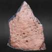
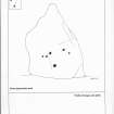
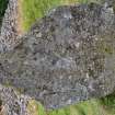
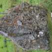
Panel notes: This schist standing stone may be in its original position but the cairn, first excavated in 1830, has been excavated a number of times since and some of the standing stones have been re-erected. At present the cup marked side of the standing stone faces roughly NW. The stone is 1.50m high, 1m wide and 0.17m thick and may have been reshaped when it was first used as a standing stone as the top is triangular. There are a few shallow fissures and the stone is covered with lichen. There are 6 circular depressions, at least 4 of which are cupmarks, scattered across the lower half of the standing stone.