Field Visit


Date 9 June 1931 - 29 May 1945
Event ID 1130111
Category Recording
Type Field Visit
Permalink http://canmore.org.uk/event/1130111
Hermitage Castle, NY 497 960.
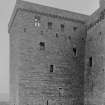
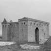
Hermitage, most perfect of the mediaeval castles on the Scottish Border, stands on the left bank of Hermitage Water in a remote moorland valley five miles N of Newcastleton and about the same distance NW of the Border on Larriston Fells. Apart from the river to the S, the situation afforded no other protection than that provided by broken and marshy ground; but except in the driest weather such ground was a formidable obstacle, and was so regarded in the mid-16th century by the compiler of a military report. He describes the castle as "a oulde house not stronng, but ewill to be wyn by reasone of the strate grounde about the same" (R B Armstrong 1883). Even so, the site has been strengthened by an extensive system of outworks. A general view is provided by the air photograph reproduced in [RCAHMS 1956] Fig. 117.
Outworks: These external defences are shown on the RCAHMS plan. The site has been sufficiently protected on the S by the river. Its flanks have been defined by the courses of two small tributaries, the Castle Sike and the Lady's Sike, parts of which have been included in a ditch, measuring about 50 ft. in breadth and 12 ft. 6 in. in depth, which runs roughly parallel to the three landward sides of the building. Ditch and streams enclose a level area, measuring 210 ft. from N to S by 200 ft. from E to W, which is separated from the river by a narrow strip of low haughland. On the N of the ditch there is an oblong base-court, measuring about 140 ft. from N to S by 260 ft. from E to W and enclosed by a stout rampart. The base-court is protected on its flanks by the two "sikes" and in front by a ditch about 60 ft. broad and 15 ft. deep.
This ditch, now traversed by the Lady's Sike, which has lately been diverted, bears a rampart on its counterscarp. The base-court appears to have been entered through the SE corner, but the opening, which was about 10 ft. wide, has been closed by a wall built across it. Lastly, there is a large mound of earth crowning the scarp of the main ditch on the W side of the castle. This is presumably a 16th-century gun-mount (cf. Historical Note infra).
The Building: The present castle may stand squarely on the site of the castle that existed in 1296 (cf. RCAHMS 1956 p.82), as there seem to be traces of early building towards the centres of the N and S walls, but the evidence is not conclusive enough to warrant the showing of this early period on the plans. Apart from this, an examination of the fabric discloses a sequence of four building-periods, and there is also evidence of the extensive restoration carried out in the early 19th century (development plans, Fig 116).
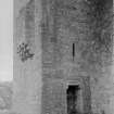
In its earliest phase the existing castle was oblong on plan and consisted of a small central court enclosed by cross-wings on the E and W and by screen-walls on the N and S sides; the S screen-wall contained the entrance, and the N one the turnpike stair. This stair never rose higher than the first floor of the wings, above which there may only have been one other storey. Such an arrangement is foreign to Scotland, but it does resemble that of some late 14th-century fortified manor-houses in the north of England, in which the constituents of the plan are a central hall flanked at each end by a cross-wing of three storeys. All that remains of this primary building at Hermitage is the lower part of the walls facing the courtyard, and whether the outer walls were entirely demolished, or were merely encased within the later walls now standing, is uncertain. The surviving primary masonry, indicated in solid black on the plan (Fig. 123), is carefully built in squared ashlar, the courses being about 14 in. high (Fig. 122). Some stones bear mason's marks, one of which, several times repeated, is an R of 14th-century character.
As reconstructed in the second period, the castle took the shape of a large tower covering roughly the same area as the primary building and measuring 45 ft. 3in. from N to S by 77 ft. from E to W. The tower was oblong on plan but for a small square projection at the SW corner, designed to house, at first-floor level, an entrance which was protected by two sets of portcullis. The open court of the first castle was now covered in, its surviving walls, reduced in height to suit new floor-levels, being utilised as internal partitions.
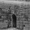
It was only in the third period, however, that the castle began to assume its present shape. In that stage small square towers were added at three corners of the main tower, and between the two towers on the N a ditch was excavated, apparently to receive sewage; the tower on the SE contained a postern on the lowest floor; and this entrance also was protected by a portcullis. The arrangement now resembled those of three Northumbrian castles, Haughton, Tarset, and Dally, all of which are said to be of the 13th century (History of Northumberland 1893)
In the fourth period an oblong wing, which incorporated the W entrance on the first floor, was thrown out from the SW corner. On the construction of this wing the superstructure of the whole building was completed with a continuous wooden hoarding projecting below the battlement. As it now stood, the castle had four main storeys.
Such were the stages in the development of the castle, the work of the third and fourth periods extending and completing the unfinished castle that was begun in the second. The first period may be dated tentatively to about 1360, the second to before 1388, the third and fourth to the turn of the 14th and 15th centuries. Later additions and alterations were of minor importance. For example, the entrances on the E and W sides were both built up and thus there was left, as the only access, a doorway at ground-level on the S side which, although later than the entrance to the original castle, stands in the same position. Then a low, outlying structure, evidently a cess-pit, was built against the S gable of the wing, where it received the contents of the drains discharging from that wall. The latest defences to be added to the structure were a few oblong gun-loops of 16th- century type.
In the 19th-century restoration most of the superstructure was rebuilt, as well as the E side, the upper part of the SE tower and the arch that links that tower to its neighbour on the N. So much at least is apparent from a sketch drawn about 1810 (W Elliot 1872), while the masonry shows that much of the N side of the castle was also renewed. The battlements, together with most of the corbelling and the wall-walk, have likewise been rebuilt.
In 1930 the castle was placed in the guardianship of HM Office of Works.
See RCAHMS 1956 75-85 for a more detailed account of the exterior and interior, and a detailed historical note.
RCAHMS 1956, visited 9 June 1931 and 29 May 1945.