
Following the launch of trove.scot in February 2025 we are now planning the retiral of some of our webservices. Canmore will be switched off on 24th June 2025. Information about the closure can be found on the HES website: Retiral of HES web services | Historic Environment Scotland
Field Visit


Date 18 November 2019 - 19 November 2019
Event ID 1125670
Category Recording
Type Field Visit
Permalink http://canmore.org.uk/event/1125670
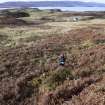
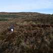
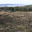
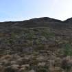
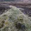
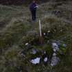
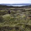
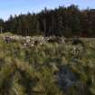
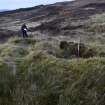
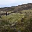
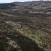
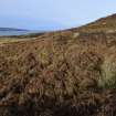
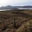
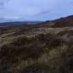
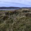
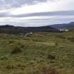
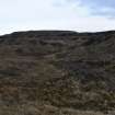
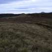
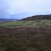
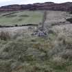
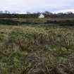
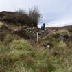
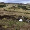
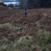
NG 25219 50480 (N area centred) and NG 25344 47923 (S area centred) A desk-based assessment and walkover survey were conducted at Totachocaire Farm, near Dunvegan, Isle of Skye. The survey area included a northern area around Totachocaire and Glen Suardal, and a southern area around Druim na Creige and St Mary’s church on the N side of Dunvegan village. The survey was required in advance of a woodland planting scheme.
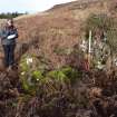
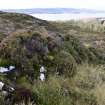
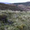
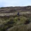
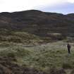
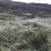
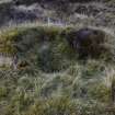
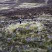
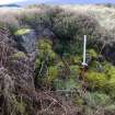
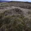
The walkover survey was undertaken on 18–19 November 2019, with a total of 65 archaeological sites identified. Sites comprised two prehistoric hut circles (Canmore ID: 10931) as well as numerous medieval and post-medieval farmsteads (Canmore ID: 114771, 114768, 114772), shielings (Canmore ID: 114769, 114773), enclosures (Canmore ID: 305913), dykes and rig and furrow cultivation remains. Mitigation measures are recommended to safeguard the sites during woodland planting.
Archive: NRHE
Funder: Scottish Woodlands
Lindsey Stirling – AOC Archaeology Group
(Source: DES Vol 21)
Ordnance Survey licence number AC0000807262. All rights reserved.
Canmore Disclaimer.
© Bluesky International Limited 2025.
|
Skye, Claigan
Sheep Dip (Period Unassigned), Sheepfold (Period Unassigned)
Canmore ID 305913 |
|
|
Skye, Creag A' Mhill
Farmstead (Period Unassigned)
Canmore ID 114772 |
|
|
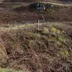
Skye, Dunvegan, Druim Na Creige, Duirinish Stone
Commemorative Stone (21st Century), Standing Stone (21st Century)
Canmore ID 293100 |
|

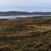
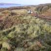
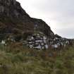
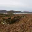
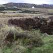
DP 422942
Walkover Survey photograph, Landscape view over enclosures and improved land around Old Suardal, Totachocaire Farm Woodland Planting, Dunvegan, Highland
Records of AOC Archaeology Group, archaeologists, Loanhead, Midlothian, Scotland
18/11/2019
© Copyright: AOC Archaeology Group. Courtesy of HES.

DP 422943
Walkover Survey photograph, Possible twinning pen (site 3), Totachocaire Farm Woodland Planting, Dunvegan, Highland
Records of AOC Archaeology Group, archaeologists, Loanhead, Midlothian, Scotland
18/11/2019
© Copyright: AOC Archaeology Group. Courtesy of HES.

DP 422944
Walkover Survey photograph, Possible twinning pen (site 3), Totachocaire Farm Woodland Planting, Dunvegan, Highland
Records of AOC Archaeology Group, archaeologists, Loanhead, Midlothian, Scotland
18/11/2019
© Copyright: AOC Archaeology Group. Courtesy of HES.

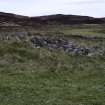
DP 422945
Walkover Survey photograph, View along stone dyke (site 34), Totachocaire Farm Woodland Planting, Dunvegan, Highland
Records of AOC Archaeology Group, archaeologists, Loanhead, Midlothian, Scotland
18/11/2019
© Copyright: AOC Archaeology Group. Courtesy of HES.

DP 422946
Walkover Survey photograph, Hut circle (site 5a), Totachocaire Farm Woodland Planting, Dunvegan, Highland
Records of AOC Archaeology Group, archaeologists, Loanhead, Midlothian, Scotland
18/11/2019
© Copyright: AOC Archaeology Group. Courtesy of HES.

DP 422947
Walkover Survey photograph, Hut circle (site 5a), Totachocaire Farm Woodland Planting, Dunvegan, Highland
Records of AOC Archaeology Group, archaeologists, Loanhead, Midlothian, Scotland
18/11/2019
© Copyright: AOC Archaeology Group. Courtesy of HES.

DP 422948
Walkover Survey photograph, Hut circle (site 5b), Totachocaire Farm Woodland Planting, Dunvegan, Highland
Records of AOC Archaeology Group, archaeologists, Loanhead, Midlothian, Scotland
18/11/2019
© Copyright: AOC Archaeology Group. Courtesy of HES.

DP 422949
Walkover Survey photograph, Stone dyke and twinning pen (site 6), Totachocaire Farm Woodland Planting, Dunvegan, Highland
Records of AOC Archaeology Group, archaeologists, Loanhead, Midlothian, Scotland
18/11/2019
© Copyright: AOC Archaeology Group. Courtesy of HES.

DP 422950
Walkover Survey photograph, Stone dyke and twinning pen (site 6), Totachocaire Farm Woodland Planting, Dunvegan, Highland
Records of AOC Archaeology Group, archaeologists, Loanhead, Midlothian, Scotland
18/11/2019
© Copyright: AOC Archaeology Group. Courtesy of HES.

DP 422951
Walkover Survey photograph, Shieling (site 7a), Totachocaire Farm Woodland Planting, Dunvegan, Highland
Records of AOC Archaeology Group, archaeologists, Loanhead, Midlothian, Scotland
18/11/2019
© Copyright: AOC Archaeology Group. Courtesy of HES.

DP 422952
Walkover Survey photograph, Looking over shieling settlement (site 7), Totachocaire Farm Woodland Planting, Dunvegan, Highland
Records of AOC Archaeology Group, archaeologists, Loanhead, Midlothian, Scotland
18/11/2019
© Copyright: AOC Archaeology Group. Courtesy of HES.

DP 422953
Walkover Survey photograph, Shieling (site 7c), Totachocaire Farm Woodland Planting, Dunvegan, Highland
Records of AOC Archaeology Group, archaeologists, Loanhead, Midlothian, Scotland
18/11/2019
© Copyright: AOC Archaeology Group. Courtesy of HES.

DP 422954
Walkover Survey photograph, Shieling and twinning pen (site 7d), Totachocaire Farm Woodland Planting, Dunvegan, Highland
Records of AOC Archaeology Group, archaeologists, Loanhead, Midlothian, Scotland
18/11/2019
© Copyright: AOC Archaeology Group. Courtesy of HES.

DP 422955
Walkover Survey photograph, Shieling (site 7f), Totachocaire Farm Woodland Planting, Dunvegan, Highland
Records of AOC Archaeology Group, archaeologists, Loanhead, Midlothian, Scotland
18/11/2019
© Copyright: AOC Archaeology Group. Courtesy of HES.

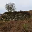
DP 422956
Walkover Survey photograph, Stone farmstead building (site 1), Totachocaire Farm Woodland Planting, Dunvegan, Highland
Records of AOC Archaeology Group, archaeologists, Loanhead, Midlothian, Scotland
18/11/2019
© Copyright: AOC Archaeology Group. Courtesy of HES.

DP 422957
Walkover Survey photograph, Shielings (site 7g left and 7h right), Totachocaire Farm Woodland Planting, Dunvegan, Highland
Records of AOC Archaeology Group, archaeologists, Loanhead, Midlothian, Scotland
18/11/2019
© Copyright: AOC Archaeology Group. Courtesy of HES.

DP 422958
Walkover Survey photograph, Shieling (site 7g), Totachocaire Farm Woodland Planting, Dunvegan, Highland
Records of AOC Archaeology Group, archaeologists, Loanhead, Midlothian, Scotland
18/11/2019
© Copyright: AOC Archaeology Group. Courtesy of HES.

DP 422959
Walkover Survey photograph, Horseshoe-shaped bank (site 7i) with mound in the background, Totachocaire Farm Woodland Planting, Dunvegan, Highland
Records of AOC Archaeology Group, archaeologists, Loanhead, Midlothian, Scotland
18/11/2019
© Copyright: AOC Archaeology Group. Courtesy of HES.

DP 422960
Walkover Survey photograph, Possible shieling site (site 7j), Totachocaire Farm Woodland Planting, Dunvegan, Highland
Records of AOC Archaeology Group, archaeologists, Loanhead, Midlothian, Scotland
18/11/2019
© Copyright: AOC Archaeology Group. Courtesy of HES.

DP 422961
Walkover Survey photograph, Boulder structures (sites 8a-b), Totachocaire Farm Woodland Planting, Dunvegan, Highland
Records of AOC Archaeology Group, archaeologists, Loanhead, Midlothian, Scotland
18/11/2019
© Copyright: AOC Archaeology Group. Courtesy of HES.

DP 422962
Walkover Survey photograph, Stone structure (site 9a), Totachocaire Farm Woodland Planting, Dunvegan, Highland
Records of AOC Archaeology Group, archaeologists, Loanhead, Midlothian, Scotland
18/11/2019
© Copyright: AOC Archaeology Group. Courtesy of HES.

DP 422963
Walkover Survey photograph, Possible stone structures (site 2), Totachocaire Farm Woodland Planting, Dunvegan, Highland
Records of AOC Archaeology Group, archaeologists, Loanhead, Midlothian, Scotland
18/11/2019
© Copyright: AOC Archaeology Group. Courtesy of HES.

DP 422964
Walkover Survey photograph, Possible stone structures (site 2), Totachocaire Farm Woodland Planting, Dunvegan, Highland
Records of AOC Archaeology Group, archaeologists, Loanhead, Midlothian, Scotland
18/11/2019
© Copyright: AOC Archaeology Group. Courtesy of HES.

DP 422965
Walkover Survey photograph, Looking over enclosure (site 34b), Totachocaire Farm Woodland Planting, Dunvegan, Highland
Records of AOC Archaeology Group, archaeologists, Loanhead, Midlothian, Scotland
18/11/2019
© Copyright: AOC Archaeology Group. Courtesy of HES.

DP 422966
Walkover Survey photograph, View along stone dyke (site 34), Totachocaire Farm Woodland Planting, Dunvegan, Highland
Records of AOC Archaeology Group, archaeologists, Loanhead, Midlothian, Scotland
18/11/2019
© Copyright: AOC Archaeology Group. Courtesy of HES.

DP 422967
Walkover Survey photograph, Stone building (site 13a), Totachocaire Farm Woodland Planting, Dunvegan, Highland
Records of AOC Archaeology Group, archaeologists, Loanhead, Midlothian, Scotland
18/11/2019
© Copyright: AOC Archaeology Group. Courtesy of HES.

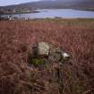
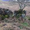
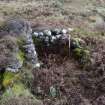
DP 422979
Walkover Survey photograph, Stone cairn (site 25), Totachocaire Farm Woodland Planting, Dunvegan, Highland
Records of AOC Archaeology Group, archaeologists, Loanhead, Midlothian, Scotland
19/11/2019
© Copyright: AOC Archaeology Group. Courtesy of HES.

DP 422980
Walkover Survey photograph, Stone structure (site 11), Totachocaire Farm Woodland Planting, Dunvegan, Highland
Records of AOC Archaeology Group, archaeologists, Loanhead, Midlothian, Scotland
19/11/2019
© Copyright: AOC Archaeology Group. Courtesy of HES.

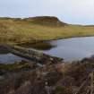
DP 422981
Walkover Survey photograph, Dam on Loch Suardal (site 12), Totachocaire Farm Woodland Planting, Dunvegan, Highland
Records of AOC Archaeology Group, archaeologists, Loanhead, Midlothian, Scotland
19/11/2019
© Copyright: AOC Archaeology Group. Courtesy of HES.

DP 422982
Walkover Survey photograph, Stone structure (site 9a), Totachocaire Farm Woodland Planting, Dunvegan, Highland
Records of AOC Archaeology Group, archaeologists, Loanhead, Midlothian, Scotland
19/11/2019
© Copyright: AOC Archaeology Group. Courtesy of HES.

DP 422983
Walkover Survey photograph, Stone structure (site 9b), Totachocaire Farm Woodland Planting, Dunvegan, Highland
Records of AOC Archaeology Group, archaeologists, Loanhead, Midlothian, Scotland
19/11/2019
© Copyright: AOC Archaeology Group. Courtesy of HES.

DP 422984
Walkover Survey photograph, Stone pen (site 9c) attached to dyke, Totachocaire Farm Woodland Planting, Dunvegan, Highland
Records of AOC Archaeology Group, archaeologists, Loanhead, Midlothian, Scotland
19/11/2019
© Copyright: AOC Archaeology Group. Courtesy of HES.

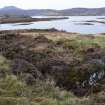
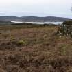
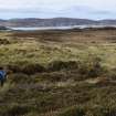
DP 422985
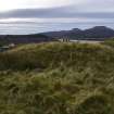
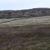
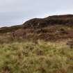
Walkover Survey photograph, Landscape view towards Totachocaire, Totachocaire Farm Woodland Planting, Dunvegan, Highland
Records of AOC Archaeology Group, archaeologists, Loanhead, Midlothian, Scotland
19/11/2019
© Copyright: AOC Archaeology Group. Courtesy of HES.

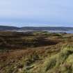
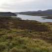
DP 422986
Walkover Survey photograph, Landscape view towards Old Suardal, Totachocaire Farm Woodland Planting, Dunvegan, Highland
Records of AOC Archaeology Group, archaeologists, Loanhead, Midlothian, Scotland
19/11/2019
© Copyright: AOC Archaeology Group. Courtesy of HES.

DP 422987
Walkover Survey photograph, Stone buildings (site 13) in landscape, Totachocaire Farm Woodland Planting, Dunvegan, Highland
Records of AOC Archaeology Group, archaeologists, Loanhead, Midlothian, Scotland
19/11/2019
© Copyright: AOC Archaeology Group. Courtesy of HES.

DP 422988
Walkover Survey photograph, Stone building (site 13a), Totachocaire Farm Woodland Planting, Dunvegan, Highland
Records of AOC Archaeology Group, archaeologists, Loanhead, Midlothian, Scotland
19/11/2019
© Copyright: AOC Archaeology Group. Courtesy of HES.

DP 422989
Walkover Survey photograph, Stone building (site 13a), Totachocaire Farm Woodland Planting, Dunvegan, Highland
Records of AOC Archaeology Group, archaeologists, Loanhead, Midlothian, Scotland
19/11/2019
© Copyright: AOC Archaeology Group. Courtesy of HES.

DP 422990
Walkover Survey photograph, Stone building (site 13b), Totachocaire Farm Woodland Planting, Dunvegan, Highland
Records of AOC Archaeology Group, archaeologists, Loanhead, Midlothian, Scotland
19/11/2019
© Copyright: AOC Archaeology Group. Courtesy of HES.

DP 422991
Walkover Survey photograph, Stone building (site 13b), Totachocaire Farm Woodland Planting, Dunvegan, Highland
Records of AOC Archaeology Group, archaeologists, Loanhead, Midlothian, Scotland
19/11/2019
© Copyright: AOC Archaeology Group. Courtesy of HES.

DP 422992
Walkover Survey photograph, Stone building (site 13b), Totachocaire Farm Woodland Planting, Dunvegan, Highland
Records of AOC Archaeology Group, archaeologists, Loanhead, Midlothian, Scotland
19/11/2019
© Copyright: AOC Archaeology Group. Courtesy of HES.

DP 422993
Walkover Survey photograph, Middle room of building (site 13b), Totachocaire Farm Woodland Planting, Dunvegan, Highland
Records of AOC Archaeology Group, archaeologists, Loanhead, Midlothian, Scotland
19/11/2019
© Copyright: AOC Archaeology Group. Courtesy of HES.

DP 422994
Walkover Survey photograph, Attached cell at NW end of building (site 13b), Totachocaire Farm Woodland Planting, Dunvegan, Highland
Records of AOC Archaeology Group, archaeologists, Loanhead, Midlothian, Scotland
19/11/2019
© Copyright: AOC Archaeology Group. Courtesy of HES.

DP 422995
Walkover Survey photograph, SE gable wall of building (site 13b), Totachocaire Farm Woodland Planting, Dunvegan, Highland
Records of AOC Archaeology Group, archaeologists, Loanhead, Midlothian, Scotland
19/11/2019
© Copyright: AOC Archaeology Group. Courtesy of HES.

DP 422996
Walkover Survey photograph, Kaleyard enclosure (site 13c), Totachocaire Farm Woodland Planting, Dunvegan, Highland
Records of AOC Archaeology Group, archaeologists, Loanhead, Midlothian, Scotland
19/11/2019
© Copyright: AOC Archaeology Group. Courtesy of HES.

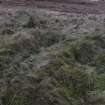
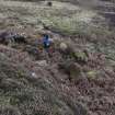
DP 422997
Walkover Survey photograph, Area of rig and furrow (site 59), Totachocaire Farm Woodland Planting, Dunvegan, Highland
Records of AOC Archaeology Group, archaeologists, Loanhead, Midlothian, Scotland
19/11/2019
© Copyright: AOC Archaeology Group. Courtesy of HES.

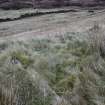
DP 422998
Walkover Survey photograph, Area of rig and furrow (site 61), Totachocaire Farm Woodland Planting, Dunvegan, Highland
Records of AOC Archaeology Group, archaeologists, Loanhead, Midlothian, Scotland
19/11/2019
© Copyright: AOC Archaeology Group. Courtesy of HES.

DP 422999
Walkover Survey photograph, Stone structure (Site 14a), Totachocaire Farm Woodland Planting, Dunvegan, Highland
Records of AOC Archaeology Group, archaeologists, Loanhead, Midlothian, Scotland
19/11/2019
© Copyright: AOC Archaeology Group. Courtesy of HES.

DP 423000
Walkover Survey photograph, Blocked entrance in structure (site 14b), Totachocaire Farm Woodland Planting, Dunvegan, Highland
Records of AOC Archaeology Group, archaeologists, Loanhead, Midlothian, Scotland
19/11/2019
© Copyright: AOC Archaeology Group. Courtesy of HES.

DP 423001
Walkover Survey photograph, Stone structure (site 14b), Totachocaire Farm Woodland Planting, Dunvegan, Highland
Records of AOC Archaeology Group, archaeologists, Loanhead, Midlothian, Scotland
19/11/2019
© Copyright: AOC Archaeology Group. Courtesy of HES.

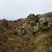
DP 423002
Walkover Survey photograph, Stone structure (site 15), Totachocaire Farm Woodland Planting, Dunvegan, Highland
Records of AOC Archaeology Group, archaeologists, Loanhead, Midlothian, Scotland
19/11/2019
© Copyright: AOC Archaeology Group. Courtesy of HES.

DP 423003
Walkover Survey photograph, Twinning pen built into structure (site 15), Totachocaire Farm Woodland Planting, Dunvegan, Highland
Records of AOC Archaeology Group, archaeologists, Loanhead, Midlothian, Scotland
19/11/2019
© Copyright: AOC Archaeology Group. Courtesy of HES.

DP 423004
Walkover Survey photograph, Stone structure (site 15), Totachocaire Farm Woodland Planting, Dunvegan, Highland
Records of AOC Archaeology Group, archaeologists, Loanhead, Midlothian, Scotland
19/11/2019
© Copyright: AOC Archaeology Group. Courtesy of HES.

DP 423005
Walkover Survey photograph, Stone structure and kaleyard (site 16a-b), Totachocaire Farm Woodland Planting, Dunvegan, Highland
Records of AOC Archaeology Group, archaeologists, Loanhead, Midlothian, Scotland
19/11/2019
© Copyright: AOC Archaeology Group. Courtesy of HES.

DP 423006
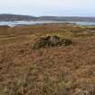
Walkover Survey photograph, Possible clearance cairn (site 17a), Totachocaire Farm Woodland Planting, Dunvegan, Highland
Records of AOC Archaeology Group, archaeologists, Loanhead, Midlothian, Scotland
19/11/2019
© Copyright: AOC Archaeology Group. Courtesy of HES.

DP 423007
Walkover Survey photograph, Possible clearance cairn (site 17a), Totachocaire Farm Woodland Planting, Dunvegan, Highland
Records of AOC Archaeology Group, archaeologists, Loanhead, Midlothian, Scotland
19/11/2019
© Copyright: AOC Archaeology Group. Courtesy of HES.

DP 423008
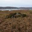
Walkover Survey photograph, Possible clearance cairn (site 17b), Totachocaire Farm Woodland Planting, Dunvegan, Highland
Records of AOC Archaeology Group, archaeologists, Loanhead, Midlothian, Scotland
19/11/2019
© Copyright: AOC Archaeology Group. Courtesy of HES.

DP 423009
Walkover Survey photograph, Possible clearance cairn (site 17c), Totachocaire Farm Woodland Planting, Dunvegan, Highland
Records of AOC Archaeology Group, archaeologists, Loanhead, Midlothian, Scotland
19/11/2019
© Copyright: AOC Archaeology Group. Courtesy of HES.

DP 423010
Walkover Survey photograph, Possible clearance cairn (site 17d), Totachocaire Farm Woodland Planting, Dunvegan, Highland
Records of AOC Archaeology Group, archaeologists, Loanhead, Midlothian, Scotland
19/11/2019
© Copyright: AOC Archaeology Group. Courtesy of HES.

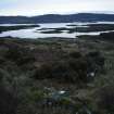
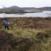
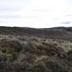
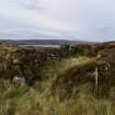
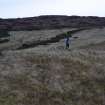
DP 423011
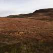
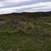
Walkover Survey photograph, Landscape view over N end of Allt Tot' a Chocaire, Totachocaire Farm Woodland Planting, Dunvegan, Highland
Records of AOC Archaeology Group, archaeologists, Loanhead, Midlothian, Scotland
19/11/2019
© Copyright: AOC Archaeology Group. Courtesy of HES.

DP 423012
Walkover Survey photograph, Possible structure (site 18), Totachocaire Farm Woodland Planting, Dunvegan, Highland
Records of AOC Archaeology Group, archaeologists, Loanhead, Midlothian, Scotland
19/11/2019
© Copyright: AOC Archaeology Group. Courtesy of HES.

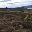
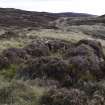
DP 423013
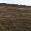
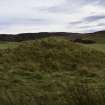
Walkover Survey photograph, Landscape view over dykes (site 52), Totachocaire Farm Woodland Planting, Dunvegan, Highland
Records of AOC Archaeology Group, archaeologists, Loanhead, Midlothian, Scotland
19/11/2019
© Copyright: AOC Archaeology Group. Courtesy of HES.

DP 423014
Walkover Survey photograph, Shielings and enclosure (site 19), Totachocaire Farm Woodland Planting, Dunvegan, Highland
Records of AOC Archaeology Group, archaeologists, Loanhead, Midlothian, Scotland
19/11/2019
© Copyright: AOC Archaeology Group. Courtesy of HES.

DP 423015
Walkover Survey photograph, Shielings and enclosure (site 19), Totachocaire Farm Woodland Planting, Dunvegan, Highland
Records of AOC Archaeology Group, archaeologists, Loanhead, Midlothian, Scotland
19/11/2019
© Copyright: AOC Archaeology Group. Courtesy of HES.

DP 423016
Walkover Survey photograph, Possible shieling site (site 19a), Totachocaire Farm Woodland Planting, Dunvegan, Highland
Records of AOC Archaeology Group, archaeologists, Loanhead, Midlothian, Scotland
19/11/2019
© Copyright: AOC Archaeology Group. Courtesy of HES.

DP 423017
Walkover Survey photograph, Possible shieling site (site 19b), Totachocaire Farm Woodland Planting, Dunvegan, Highland
Records of AOC Archaeology Group, archaeologists, Loanhead, Midlothian, Scotland
19/11/2019
© Copyright: AOC Archaeology Group. Courtesy of HES.

DP 423018
Walkover Survey photograph, Possible shieling site (site 20), Totachocaire Farm Woodland Planting, Dunvegan, Highland
Records of AOC Archaeology Group, archaeologists, Loanhead, Midlothian, Scotland
19/11/2019
© Copyright: AOC Archaeology Group. Courtesy of HES.

DP 423019
Walkover Survey photograph, View along stone dyke (site 47) with turf dyke (site 46) in foreground, Totachocaire Farm Woodland Planting, Dunvegan, Highland
Records of AOC Archaeology Group, archaeologists, Loanhead, Midlothian, Scotland
19/11/2019
© Copyright: AOC Archaeology Group. Courtesy of HES.

DP 423020
Walkover Survey photograph, Overlooking modern fenced sheep fank, Totachocaire Farm Woodland Planting, Dunvegan, Highland
Records of AOC Archaeology Group, archaeologists, Loanhead, Midlothian, Scotland
19/11/2019
© Copyright: AOC Archaeology Group. Courtesy of HES.

DP 423021
Walkover Survey photograph, Stone building (site 22), Totachocaire Farm Woodland Planting, Dunvegan, Highland
Records of AOC Archaeology Group, archaeologists, Loanhead, Midlothian, Scotland
19/11/2019
© Copyright: AOC Archaeology Group. Courtesy of HES.

DP 423022
Walkover Survey photograph, Stone building (site 22), Totachocaire Farm Woodland Planting, Dunvegan, Highland
Records of AOC Archaeology Group, archaeologists, Loanhead, Midlothian, Scotland
19/11/2019
© Copyright: AOC Archaeology Group. Courtesy of HES.

DP 423023
Walkover Survey photograph, Stone buildings (site 21a-b), Totachocaire Farm Woodland Planting, Dunvegan, Highland
Records of AOC Archaeology Group, archaeologists, Loanhead, Midlothian, Scotland
19/11/2019
© Copyright: AOC Archaeology Group. Courtesy of HES.

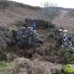
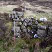
DP 423024
Walkover Survey photograph, Stone structure (site 23), Totachocaire Farm Woodland Planting, Dunvegan, Highland
Records of AOC Archaeology Group, archaeologists, Loanhead, Midlothian, Scotland
19/11/2019
© Copyright: AOC Archaeology Group. Courtesy of HES.

DP 423025
Walkover Survey photograph, Twinning pen built into structure (site 23), Totachocaire Farm Woodland Planting, Dunvegan, Highland
Records of AOC Archaeology Group, archaeologists, Loanhead, Midlothian, Scotland
19/11/2019
© Copyright: AOC Archaeology Group. Courtesy of HES.

DP 423026
Walkover Survey photograph, Stone structure (site 23), Totachocaire Farm Woodland Planting, Dunvegan, Highland
Records of AOC Archaeology Group, archaeologists, Loanhead, Midlothian, Scotland
19/11/2019
© Copyright: AOC Archaeology Group. Courtesy of HES.

DP 423027
Walkover Survey photograph, Possible structure (site 24), Totachocaire Farm Woodland Planting, Dunvegan, Highland
Records of AOC Archaeology Group, archaeologists, Loanhead, Midlothian, Scotland
19/11/2019
© Copyright: AOC Archaeology Group. Courtesy of HES.


Walkover Survey photograph, Twinning pen built into structure (site 23), Totachocaire Farm Woodland Planting, Dunvegan, Highland
Walkover Survey photograph, Stone structure (site 23), Totachocaire Farm Woodland Planting, Dunvegan, Highland
Walkover Survey photograph, Possible structure (site 24), Totachocaire Farm Woodland Planting, Dunvegan, Highland
