Field Visit


Date November 1973
Event ID 1124264
Category Recording
Type Field Visit
Permalink http://canmore.org.uk/event/1124264
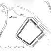
NS 731 538. Roman Fort, Bothwellhaugh; the Roman fort of Bothwellhaugh (RCAHMS 1978, Fig. 73) occupies a strong defensive position on the right bank of the River Clyde immediately NE of its confluence with the South Calder Water, overlooking the now wholly inundated haughs to the E of Bothwell village from which the site takes its name. Its existence was first recorded at the end of the 18th century (Stat. Acct., iii, 458), at which time cultivation was just beginning to encroach upon the remains. In the course of the next century, however, the site was so heavily damaged by agriculture and afforestation that it was only rediscovered shortly before the Second World War, and identified as Roman by excavation. The examination, carried out by J M Davidson in 1938-9 (Davidson 1952), was restricted to the defences of the fort on the NW, SW and SE sides, the rampart and ditches on the remaining side being located by the Commission in 1967- 8 (Maxwell 1975). An external bath-house [NS75NW 23], subsequently discovered by the Commission's officers to the NW of the fort during the construction of a roadway for the newly created Strathclyde Park, was excavated in 1975 (Keppie and Mackenzie 1975*), and, at the time of writing is threatened with inundation. The following account and the accompanying plan are thus based upon three excavation reports.**
The fort is situated at the W end of a broad level promontory, protected on the NW and SW by an abrupt fall of 16 m to the banks of the South Calder Water and the River Clyde respectively. Between the fort and the equally steep NE flank of the promontory there is an extensive area of flat ground, which was probably traversed by the Roman road No. 264. The easiest access was by way of the comparatively narrow neck of the promontory on the E. The site is at present obscured by a dense growth of scrub, and only the SE and NE ramparts can still be clearly seen above ground, the former appearing as a grassy bank standing 1.5 m in maximum height and spread in places to a thickness of more than 15 m, the latter, 1.1 m in average height, being partly masked by a modern track and a field boundary that cut obliquely across it.
Excavation showed that the fort was trapezoidal on plan; its dimensions over the rampart were approximately 152 m by 131 m and it occupied an area of 1·65 ha (4.1acres). The main defence had been a clay rampart measuring from 7'2 m to 8'1 m in thickness, the inner and outer face of which were originally supported by a stone base. There was evidence to show that at some time the rampart front, at least on the NE, had been repaired; to the S of the NE gate the original outer face had been cut away and replaced with a turf cheek, while to the N the turf had been applied as an additional revetment which increased the rampart thickness beside the gate by as much as 1·8 m but which diminished in width towards the N angle. It is possible that the curious stepped appearance of the rampart foundation on the SW, which was thought to be a structural device to provide a firm base for the rampart on the crest of the escarpment, may also have resulted from a secondary repair. The ditches varied in number and dimensions: two were considered necessary on the more vulnerable NE and SE, but apparently only one on each of the remaining sides; at Roman ground-level the ditches measured from 5.2 m to 1.5 m in width and from 1.2 m to 0·6 m in depth, the deepest and widest being found on the SE front. The positions of all the entrances except that on the SW have been approximately determined by excavation, but none has been examined in detail. Nevertheless, it seems likely that the NE gate was twin-portalled and that the entrance-passage, which measured approximately 6 m in width, was flanked on each side by a timber tower incorporating a guard chamber in its ground floor. Little is known about the street plan or the internal buildings, save that some structures at least were of timber and exhibited two structural phases. Further secondary work was observed on the SE side of the fort, where an oven built against the inner rampart-face had subsequently been demolished and incorporated in a ramp, probably an ascensus, which contained fragments of brick and tile from a hypocausted structure. The external bath-house [NS75NW 23], which lay close to the left bank of the South Calder Water 95 m NW of the fort, displayed two structural phases and was of simple plan. In its ruins there was discovered a fragment of a building record bearing the letters C O H (cohors).
The identity of the garrison is unknown, but consideration of the size of the fort suggests that it may have been a cohors quingenaria equitata. All the relics recovered from the site are of Antonine date.
RCAHMS 1978, visited November 1973.
*The Commissioners are indebted to the excavator, Mr L J F Keppie, for assistance in preparing this report.
**Certain discrepancies which can be detected between Davidson's account and his published plan (South-western Scotland, pl. lxii) suggest that the latter was intended rather as a sketch: in particular the N angle appears to be displaced about 10 m to the NW. The plan and measurements given here thus represent an attempt to correlate the visible surface traces and the results of the 1938-9 and 1967-8 excavations.