Field Visit


Date 26 August 1913
Event ID 1115280
Category Recording
Type Field Visit
Permalink http://canmore.org.uk/event/1115280
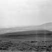
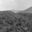
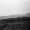
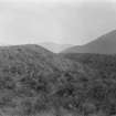
Fort, Castle Law.
On the summit of Castle-Knowe, a small hill on the southeastern slope of the Pentland Hills, on the northern side of the glen through which the Glencorse Burn issues from the hills, is the Castle Law fort (Fig. 103). It lies some 200 yards north of Castle Law farm, at an elevation of 1000 feet above sea-level, commanding a view of Lawhead fort [NT26SW 7], which lies about 1 ¼ miles to the south-west. The approach is steep on all sides except towards the north, where there is a dip of only a few feet into a hollow about 100 yards wide, which separates the hill from the main mass of the Pentlands.
The fort is oval on plan, the main axis running east-north-east and west-south-west, along which it measures internally some 270 feet, the breadth being on an average about 120 feet. It is surrounded by a series of earthen ramparts and ditches, the arrangement of which is not regular for the entire periphery, and it is provided with three entrances, one at either end and the third near the centre of the southern flank. The two outer defences are well preserved along the northern flank, but at all other parts the construction is now much broken down. The enceinte has been surrounded by a rampart, which for the greater part has been almost entirely obliterated. At an interval of approximately 50 feet from this a second earthen wall entirely encircles the fort, and a third line of defence has been constructed on the north and the south-western sides at a further interval of 35 feet. At most these ramparts do not rise to a height of more than 2 feet on the inside and 4 feet on the outside. The entrance in the south-western corner of the fort is 10 feet broad at the inner rampart, where the passage is excavated below the level of the interior. On emerging from the inner defence it swings to the right and is carried through the outer defences in a north-westerly direction. The entrance on the southern flank has likewise cut through the outer defences, in a slightly oblique and north-easterly direction, and it has been similarly excavated below the level, where it enters the enceinte in the form of a bifurcated passage. The north-eastern entrance makes a gap 12 feet broad in the inner rampart, and breaks the line of the second defence for approximately 35 feet, where a low-lying ridge or mound thrown across the opening on the outside may be the remains of an outer traverse to protect the passage. In front of this entrance is a pear-shaped mound or bastion, which has no hollow in the centre to suggest that it was a guard-chamber. Between the outer and inner ramparts, immediately to the south-east of the roadway, is a low, narrow, curved enclosure,65 feet in length, with a bulbous outline in the centre of its western flank and open at its northern end, where it approaches the northeastern entrance to the fort.
RCAHMS 1929, visited 26 August 1913.
OS map: vii S.W.