Pricing Change
New pricing for orders of material from this site will come into place shortly. Charges for supply of digital images, digitisation on demand, prints and licensing will be altered.
Field Visit


Date 15 July 1953
Event ID 1111164
Category Recording
Type Field Visit
Permalink http://canmore.org.uk/event/1111164
NS88sw 833 849
Broch, The Tappoch, Tor Wood.
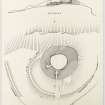
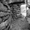
This broch (Fig. 24, DP 170489) is situated at a height of 380 ft. O.D. near the centre of Tor Wood, 700 yds. WSW. of spot-level 214 on the by-road that runs from Larbert to Stirling by West Plean. It can be seen on the skyline from this point. Its position is a typical one for a Lowland broch; it stands on the brink of a broken rocky slope so that in one direction it commands wide views-in this case the slope falls to the W. and the views extend from WSW. through N. to ENE. -while in the opposite direction the approaches are gentle and include some ground slightly higher than that on which the broch stands.
Before the structure was excavated in 1864 (1) it appeared simply as a mound, the only indication that it might not be natural being provided by laid stones appearing in its SE. sector. It is plain that the excavators, even when they had cleared the interior, remained under the impression that the structure was simply a chamber sunk into a natural knoll. In the course of their exploration they removed a mass of boulders and debris, which they estimated to weigh upwards of 200 tons, laid bare the inner wall-faces and an inclined floor formed by the natural rock, and opened the entrance-passage, stair lobby and stair. On the floor they found a central hearth and a number of relics described below. As was natural in view of their belief that they were dealing with a chambered mound, they made no attempt to find the outer face of the wall; and this is now almost wholly concealed by earth and debris, including that resulting from the clearance of 1864. Portions of the outer face which appear on the W., NW. and N. give wall thicknesses of from 17 ft. to 24 ft. ; these are not, however, at ground level but slightly above that of the scarcement, the thickness at present ground level, as measured along the entrance-passage, being 20 ft. 6 in.
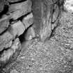
At the entrance it can be seen that the outer wall-face is battered to the extent of 9 in. in five courses. The entrance is in the SE. and is 2 ft. 7 in. wide. It is today approached by a sunken pathway made through the debris that surrounds the outside of the broch, and the stonework and kerbing seen along the sides of this pathway probably represent revetments inserted in 1864 to retain the debris. The outer portion of the entrance passage increases in breadth by one foot as it penetrates the wall, and at 9 ft. 9 in. from the outside it is checked for a door and widens to 4 ft. 6 in. Nine inches within the checks there is the usual bar-hole (Pl. 6 c, SC 1401258) on the N. side, with a recess opposite to receive the end of the bar; these openings are both 9 in. square, the former being at least 5 ft. 9 in. and the latter 1 ft. 3 in. deep. Within the checks the N. wall of the passage maintains its original alinement, but the S. wall diverges slightly and gives the passage a breadth of nearly 5 ft. at 3 ft. 5 in. behind the checks. At its inner end, 10 ft. 8 in. from the checks, the passage narrows to 2 ft. 6 in. Two passage lintels remain in situ (Pl. 6 B, SC 1401268), and the broken ends of others can be seen in the inner portion of the passage; the apparent headroom at the checks is now 5 ft. 3 in., but the true depth to the base of the passage wall was found to be 8 ft., with the result that the bar-hole is seen to have been placed at a normal height above the threshold and not, as previously appeared, within a few inches of the ground.
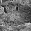
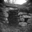
The shape of the interior (Pl. 5, SC 450981) is irregularly circular, showing a bulge where the passage enters, while the W. half is noticeably flattened. The rock floor found by the excavators has now been covered up with debris, earth and vegetation, and the surface of the court consequently stands higher than it did in 1864. It now falls 3 ft. 5 in. from W. to E. and the wall-face stands above it to a height of about 8 ft., while it measures 35 ft. 6 in. from N. to S. by 32 ft. transversely (2). The masonry consists of large, rough blocks, probably quarried from the neighbouring cliffs and outcrops, pinned with smaller material. The wall-face contains numerous small recesses (Pl. 6 A, SC 1401259) about a foot or less in height and breadth and from 1 ft. to 3 ft. in depth. Their purpose is obscure, and the excavators of 1864 reported that nothing was found in them ‘except some white clay peculiar to Torwood’ (3); on the other hand one of the two similar recesses at Coldoch broch, Perthshire, was represented in a sketch made about 1870 as divided in two by a shelf (4). Their number is difficult to calculate, as in some places rather similar cavities have resulted accidentally from the dislodgement of facing-stones, but at least thirteen may be regarded as true constructional features. At heights above the present level of the interior which vary between 4 ft. 5 in. on the W. and about 7 ft. on the E., a scarcement, 1 ft. to 1 ft. 6 in. wide and suffering from dilapidation, runs all round the internal wall-face. It can be seen that the innermost lintels of the entrance-passage and of the stair-lobby, both now vanished, formed parts of the scarcement ledge. The stair-lobby (Pl. 6 A), which retains a double lintel, enters from the court 12 ft. 3 in. to the left, or SW., of the mouth of the entrance-passage, its own entrance being 2 ft. 7 in. wide and, at present, 4 ft. 9 in. high. It extends 11 ft. into the wall, showing a recess at the SE. corner and what may be another just inside the entrance, and at its inner end returns W., widens to 4 ft. 1 in., and gives on to the foot of the stair which rises clockwise in the thickness of the wall. Eight steps now remain of the eleven reported in 1864; they are about 2 ft. 4 in. wide by 9 in. deep, and each rises about 5 in. The uppermost courses of the wall-faces flanking the steps show signs of incipient corbelling.
To N., E. and S. the broch is encircled by two wasted concentric banks the ends of which were evidently designed to rest on the brink of the rock-slopes to the W. They were examined in 1948-9 (5) and were found to represent the ruins of rubble-cored, boulder-faced walls. The inner bank now rises to a maximum height of 6 ft. 6 in., and the outer one to 3 ft. Gaps occur in both banks on a line with the entrance of the broch. The ‘third wall’, of which traces were mentioned by the excavators of 1864 as ‘extending along the face of the cliff’, can be identified with some fragmentary footings seen at a point about 40 yds. S. of the SW. end of the outer enclosing-wall. The lip of the slope dips somewhat at this point, and the slope itself is less steep than to N. and S.; a wall may consequently have been built across the dip to render access more difficult.
The small finds made in the course of the excavations include three boulders carved with cup-and-ring markings (No. 44); saddle and rotary querns (6) ; three hollowed pebbles, one of which resembles a crude version of a stone cup of the kind found at West Plean (NS88NW 5); stone balls, one a pecked sphere with an equatorial band in low relief; whorls and other small stone objects; several sherds of hand-made coarse pottery, and two of finer wares which might be mediaeval (7). The coarse pottery includes one sherd with finger-tip ornament under a thin everted rim such as has been found in other brochs (8), and two sherds of an Early Iron Age native ware of a type found in SE. Scotland at such places as Craigs Quarry, East Lothian (9). No Roman relics were recorded. Some of the finds are preserved in the National Museum of Antiquities of Scotland and others in the Falkirk Burgh Museum.
RCAHMS 1963, visited 15 July 1953.
(1) PSAS, vi (1864-6), 259 ff.
(2) The excavators recorded a height of 11 ft. 4 in. on the N. and 8 ft. 6 in. on the S., the difference from today's measurements
being accounted for by the wasting of the upper courses and by the rise in the level of the floor.
(3) PSAS, vi (1864-6), 261.
(4) Ibid., lxxxiii (1948-9), 14, n. 1.
(5) PFANHS, iv (1946-9), 89 ff.
(6) P.S.A.S. , xc (1956-7), 38, fig. 11.
(7) PFANHS, loc. cit., fig. 11, and National Museum of Antiquities No. GM 27.
(8) PFANHS, loc. cit., fig. 19, bottom right.
(9) One illustrated, ibid., bottom left; P.S.A.S., lxxxvi (1951-2) , 195, fig. 6.