Scheduled Maintenance
Please be advised that this website will undergo scheduled maintenance on the following dates: •
Every Thursday from 17th October until 7th November from 11:00 to 15:00 •
Tuesday, 22nd October from 11:00 to 15:00
During these times, some services may be temporarily unavailable. We apologise for any inconvenience this may cause.
Field Visit


Date 7 May 1953
Event ID 1111051
Category Recording
Type Field Visit
Permalink http://canmore.org.uk/event/1111051
NS 78 SE 781 825 (unnoted)
Fort, Myot Hill.
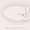
This fort is situated on the summit of Myot Hill, which rises abruptly to a height of 696 ft. above sea-level from the plain to the E. of Denny Muir. It commands wide views in all directions, including a stretch of the Antonine Wall from Bar Hill on the SW. to beyond Rough Castle on the SE. The hill falls sharply away from the summit area to N., W. and S., but to the E. a gentle slope runs evenly down to the plain. The fort (Fig. 14), which has been almost obliterated by stone-robbing and weathering, is oval on plan and measures 215 ft. in length from E. to W. by 140 ft. transversely. No traces of defences can be seen along the crests of the steep slopes to N., W. and S., but the slope to the E. is traversed by the mutilated remains of two ramparts. The inner one, a low, slightly curved mound spread to a maximum width of 13 ft., runs S. from the crest of the N. slope for a distance of 105 ft. After being broken by a gap 1 I ft. wide, which must represent the site of the original entrance, it resumes to continue in the form of a low scarp for some 25 ft. before merging into the crest of the S. slope of the hill. The outer rampart, which is only represented by a low scarp, takes a similar course to the inner one, running from a point on the N. crest of the hill at a distance 38 ft. E. of the beginning of the latter to finish 28 ft. E. of the N. side of the entrance-gap. After a break of 22 ft. It resumes in the form of a slight terrace, which runs SW. and W. for a distance of 42 ft. before fading away on the S. slopes of the hill. Apart from a small modern building, the interior is featureless.
The possible connection of the place-name Myot Hill with the tribal name Maeatae is noted by Watson (Placenames, 59).
RCAHMS 1963, visited 7 May 1953.