Pricing Change
New pricing for orders of material from this site will come into place shortly. Charges for supply of digital images, digitisation on demand, prints and licensing will be altered.
Field Visit


Date 19 June 1952
Event ID 1111005
Category Recording
Type Field Visit
Permalink http://canmore.org.uk/event/1111005
NS 832973
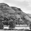
Fort, Dumyat.
The Ochil Hills stretch from the Firth of Tay WSW. for a distance of 30 miles, for the last twelve of which they are bounded to N and W by Strathallan and to S and E by the River Devon. This section of the hills is up to seven miles in breadth and is crossed by no pass. The south-westernmost of the major heights, Dumyat, rising to a height of 1375 ft. O.D., stands three and a half miles NE. of the confluence of the Allan Water and the River Forth. Its summit peak is steep and inhospitable, rising abruptly from the shoulders of the hill which reach heights of between 900 ft. and 1100 ft. OD To the N the shoulders slope gently down to the valley of the Loss Burn, some 400 ft. below and one mile distant, but to the S there is a very steep descent of 1000 ft. to the plain in which the River Devon joins the River Forth.
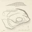
The fort (Fig. 7 [plan, DP203919], Pl. 7 B [ST1111]) is situated near the brink of this descent at a height of a little over 1000 ft. O.D., on an unnamed part of the shoulder some 500 yds. SW. of the summit of the hill and 400 yds. ESE. of the name 'Castle Law' on the O.S. 6-inch map. The innermost feature is an oval enclosure which occupies the highest part of the site and measures 90 ft. in length by 55 ft. in breadth within the massive debris of a ruined stone wall (A). No stones of either face can be distinguished among the rubble, which is spread to an average width of about 15 ft. The entrance is not distinguishable with certainty but was probably in the W. arc. The interior is featureless. A shallow depression with a slight external upcast-mound, which borders the E. arc of the debris, may be a result of the robbing of the outer face of the wall.
A ragged band of rubble (B) appears on the steep slope 35 ft. NE. of the NE. arc of wall A, and runs thence through S. and SW. at about the same interval for about 90 ft. Towards its end it bends more sharply and runs W. to merge with the debris of wall A. Another line of rubble (C) branches from the SW. arc of wall A and runs WNW. For 110 ft. to reach the debris of the outer walls described below. The fragmentary nature of B and C renders speculation about their original character and purpose difficult, but clearly the possibility exists that they might represent the ruin of a single wall which has been partly overlaid by wall A.
The outer walls (D and E) have been designed to cut off the nose of the hill from the landward approach, and are drawn across what is in effect the neck of a promontory. To S. and E. the steep faces of the hill form adequate defences, while to NE. an equally effective natural obstacle is provided by the precipitous sides of a rocky defile in which a stream called Burnwarroch runs off the hill. The inner of the two walls (D), a mass of rubble about 18 ft. in width among which some vitrified material was found, appears first on the steep N. part of the site and runs thence W. and S. to the entrance, which is 20 ft. in width. It continues thereafter along the crest of a broad, grass-covered, rocky knoll for 130 ft. and ends where the flank of this begins to slope steeply S. The outer wall (E), of similar appearance to D, starts on the lip of a rocky gully which continues SE. to join the Burnwarroch defile; the wall runs at distances varying between 40 ft. and 65 ft. from D to the N. side of the entrance, where it is 40 ft. outside the similar point in D. It resumes on the S. side of the entrance only 22 ft. from D, however, and continues thence at about the same interval, past the end of the latter, to die out 60 ft. further on, on the crest of a natural rocky slope. On each side of the entrance the walls D and E are linked by lines of rubble which probably represent ruined walls. Attached to the outside of wall E there are two enclosures, one on either side of the entrance, bounded partly by natural slopes and partly by ruined walls (F and G) only 3 ft. 6 in. in thickness. The northernmost enclosure is itself subdivided by a similar wall.
The chronological relationship between the two main elements present in this fort - the enclosure defined by wall A, and the double walls D and E - is not apparent from the superficial remains and can only be established by excavation. When the plan of the fort was first published (1), it was assumed that the work was a unitary one, walls D and E being the contemporary outer defences of a ‘citadel’ formed by wall A. The subsequent discovery in Stirlingshire of large numbers of duns, similar in plan to the ‘citadel’, suggests however that the latter may be an independent structure of the dun class which was built in the interior of an older, and presumably abandoned, fort represented by walls D and E. For convenience in obtaining building material, brochs and ring-forts were occasionally erected inside earlier, ruined fortifications (2), and, if the "citadel" is abstracted, Dumyat is not essentially different from a number of neighbouring Early Iron Age forts whose walls contain vitrified material (e.g. Abbey Craig NS89NW 10 and Braes NS78SE 4).
The name Dumyat was considered by Watson (3) to represent Dun Myat, the fortress of the Maeatae, probably the Miathi of Adamnan (4), and this view is generally held today (5). The spelling in the Statistical Account of Scotland is Dunmyatt (6), but neither this nor subsequent variations need be regarded as significant.
A small cup-shaped object of stone from ‘above Blairlogie’ (7) may have originated at the fort.
RCAHMS 1963, visited 19 June 1952.
(1) Feachem, R. W., 'Fortifications', in The Problem of the
Picts, ed. Wainwright, F. T. (1955),77; (2) E.g. Torwoodlee broch (PSAS, lxxxv (1950-1), 92 ff.); Dunearn Hill, ring-fort (Feachem, op. cit., 75). (3) Place Names, 59, 100. (4) Anderson, A O, Early Sources of Scottish History, 90, 96 f. (5) Wainwright, F. T., "The Picts and the Problem", in The Problem of the Picts, 24, etc. (6) Vol. iii (1792), 288. (7) TSNHAS, xlvi (1923-4), 142; Smith Institute Catalogue, 61, No. 4706, AH 21.