Pricing Change
New pricing for orders of material from this site will come into place shortly. Charges for supply of digital images, digitisation on demand, prints and licensing will be altered.
Upcoming Maintenance
Please be advised that this website will undergo scheduled maintenance on the following dates:
Thursday, 9 January: 11:00 AM - 3:00 PM
Thursday, 23 January: 11:00 AM - 3:00 PM
Thursday, 30 January: 11:00 AM - 3:00 PM
During these times, some functionality such as image purchasing may be temporarily unavailable. We apologise for any inconvenience this may cause.
Field Visit


Date 17 June 1921
Event ID 1105077
Category Recording
Type Field Visit
Permalink http://canmore.org.uk/event/1105077
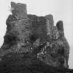
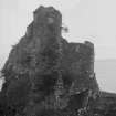
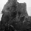
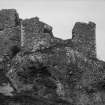
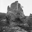
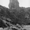
Brochel Castle.
This eyrie-like structure occupies the whole of the summit of an isolated mass of agglomerate (Torridon grit and sandstone), conspicuously placed in a small crescentic bay that breaks the line of precipitous cliffs forming the northern part of the east coast of the island of Raasay. A plantation of birch trees straggles round the face of the brae behind and follows the curve of the bay to the sea face on either side. To the north the view is closed by the rising ground, but there is a clear outlook to the Ross-shire coast in front and down the Inner Sound.
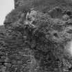
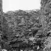
Rising from a slight slope the pinnacle of rock all round stands about 50 feet above the terrain, though the summit is in two levels, that on the east side being 20 feet above the other. On both levels there are buildings. (Fig. 252.)
The entrance is on the east face and is approached up a rather steep, narrow ridge. On the right the bare rock rises to the higher level; on the left the lower level carries the corner of the building on this side. The approach is thus narrowed, and there is evidence that originally there was some sort of overbuilding outside the present doorway-the walling on both sides was apparently continued outwards with a chamber above, providing a passage roofed with slabs, of which only the inner end now exists. Another chamber would seem to have been contrived over this surviving portion of the lintelled passage, and beyond this on the level a narrow open way continues between the rocky sides, which have been faced with stone, for 11 feet or so. In this alley are several recesses, large and small. The entrance as a whole is in a tumble-down condition; much of the building, having been but a skin on the rock face on either side, has disappeared. The entrance corridor opens upon the middle one of three apartments, which occupy the lower level and are angled upon plan to follow the ground. The walls of this middle apartment have almost wholly disappeared. On the short north-eastern face the wall is again but a facing on the rock, and then only as high as where the rock overhangs (see Fig. 253). At the north corner are recesses. The apartment to the east has been about 17 by 11 to 12 feet, but only one wall and portions of other two are left. Of the western apartment more remains, and, as laid out, this forms almost a square of 11 feet, but at the north corner what has been the stair projects inwards, while the greater part of the rest of the north-east face is occupied by a 5-feet recess with a slab lintel, the back of which is bare rock. In the north-western wall, on the upper floor, is a narrow window opening or slit splayed inwards, one jamb of which is a single stone, while the other is built up of small stones. Another similar slit in the south-west corner completes the exceedingly meagre lighting of this apartment, which, like the others, must have had a room over. (Figs. 250, 251.)
The higher level can now be reached only by scrambling up, and of the battlemented tower of two stories which, according to Wm. Daniell's view of 1819, occupied the great part of it, only some indications of the foundations remain. But on the spur of rock projecting to the north-west still stands the small triangular building which adjoined the tower, and which on the lower floor contains a couple of narrow through apartments of indeterminate purpose, while the upper floor is a single chamber. In the inner of the lower rooms on the western wall is a garderobe with an external chute. The northern end of the wall of this structure butted against the tower wall. This wing, too, had an upper floor lighted by three slits, of which one has been built up, while the lower floor has been lighted by a single slit in the north-east wall. At the apex of the triangle the upper part of the corner is built out on corbels to overhang the tower. About 12 feet high of building remains, with, on one face, some indication of the parapet in slight projection on a continuous corbel course. On the south-western face of the lower building are six of the quarter-round corbels that supported the parapet, part of the lower courses of which is in position near the corner. These are of very small stones, and there is no sign of an embrasure, but according to the 1819 view, the embrasures on the tower, and so no doubt here also, were few - two on a face - and at a rather higher level than the fragment which remains.
The building is in roughly coursed blocks of sandstone and basalt of all shapes and sizes, embedded in plentiful mortar of shell lime and gravel, and is in a very bad state. The walls are nowhere more than 4 feet thick. It may be noted that, in the Daniell picture, what looks like an approach and entrance to the right on the lower level cannot have been intended to suggest such, as there is no indication of anything of the kind, and, where a door might be expected to exist, there is really a small chute from the interior.
HISTORICAL NOTE. Dean Monro (1549) gives two castles to Raasay, "the castle of Killmorocht (cf. No. 592) and the castle of Brolokit, with twa fair orchards at the saids twa castells." The Description of the Isles (1577-95) in Skene says that Macleod of Raasay “hes ane strange little castell in this Ile, biggit on the heid of ane heich craig, and is callit Prokill." Martin (1695) describes it as "an artificial fort, three stories high . . .called Castle Vreokle."
RCAHMS 1928, visited 17 June 1921.
OS map: Skye xxv.