Field Visit


Date 6 June 1921
Event ID 1105041
Category Recording
Type Field Visit
Permalink http://canmore.org.uk/event/1105041
Dun Skudiburgh.
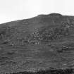
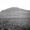
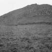
On the eastern shore of Loch Snizort, about 1¾ miles west-north-west of Uig, and ¾ mile north of Ru Idrigil, the promontory on the north side of the mouth of Uig Bay, is a rocky ridge running north-west and south-east, and rising to a height of 100 feet above the sea to the west, and about 50 feet above the hollow which intervenes between it and Creag Liath, a hill 563 feet high on the east. The highest part, a grassy plateau of considerable extent, is towards the southern end of the height which narrows and tails away to the north in a series of terraces and slopes defined by outcrops of rock. The southern end and western flank are precipitous, and on the east it is steep and rocky.
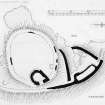
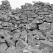
A stone wall probably 9 to 13 feet thick, but now almost obliterated, has been erected within a few feet of the edge of the rocks to enclose an oval-shaped plateau. There is no entrance visible. (Fig. 212.)
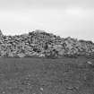
At the north-east of this enclosure are the remains of a drystone building showing a number of interesting features. Somewhat drop-shaped on plan, with the apex to the north, its axes measure internally 35 feet in length and 25 feet in breadth. The wall is built with a considerable batter, and in places rises to a height of 9 feet on the outside and 4 feet above the debris in the interior. It varies from about 9 feet thick on the north to 12 feet at the base round the southern arc, where roughly 2 feet or so above the ground it is reduced to 7 feet in thickness by an intake on the outer and inner faces. At the northern corner is a recess 7 feet 4 inches in width and 2 feet in depth. The entrance is indistinguishable, but was no doubt on the east where the wall is most dilapidated. Abutting on the inside of the northern part of the wall of the inner court and 25 feet north-west of this building is a hut circle 12 to 14 feet in diameter.
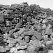
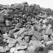
Beyond the inner wall and at a lower level an outer stone wall 7 to 9 ½ feet in thickness has started from the edge of the cliff at the south-eastern end of the ridge, and has been carried in a slight curve along. the entire length of the eastern edge of the ridge. The southern half is totally destroyed, but the whole can be followed for 320 feet northwards, where it returns for 75 feet in a south-westerly direction and then curves southwards for 25 feet to meet the cliff on the western flank, thus forming on the northern slope a large triangular outer courtyard, of which a cross wall, about 100 feet in length and 6 ½ to 9 ½ feet in thickness, with the rocky shelf on which it is built, is the base. South of this cross wall a lesser triangularly-shaped area slopes downwards from the main wall.
In the outer courtyard on the northern slope are two hut circles abutting on the inside of the western wall and traces of probably two others. Along the inside of the eastern wall is a long narrow area about 59 by 14 feet internally, enclosed by stone foundations averaging 5 feet in thickness. On the terracing at the southern end of the outer wall is a rectangular depression 12 feet wide and of indefinite length.
The entrance to the fort, 8 feet wide, is at the northern extremity and pierces the wall of the outer courtyard at its lowest level. The roadway, defined by a distinct hollow enflanked on the east by the outer wall and the foundations of the narrow area before mentioned, is carried up the hill and passes through a gap between the cross wall and the eastern outer wall along the side of which it continues, but itis impossible to say whether it entered the summit before or after the drop-shaped building was reached.
On the western side of the ridge is a terrace which lies some 50 feet lower than the summit and is bounded on the outside by a high cliff. On this terrace there are considerable debris and the remains of a stone wall, apparently of later construction, built from the base of the cliff above to the edge of the cliff below.
RCAHMS 1928, visited 6 June 1921.
OS map: Skye vi.