Following the launch of trove.scot in February 2025 we are now planning the retiral of some of our webservices. Canmore will be switched off on 24th June 2025. Information about the closure can be found on the HES website: Retiral of HES web services | Historic Environment Scotland
Field Visit


Date 4 June 1921
Event ID 1105033
Category Recording
Type Field Visit
Permalink http://canmore.org.uk/event/1105033
Duntulm Castle.
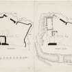
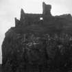
This later seat of the Macdonalds of Sleat occupies the seaward end of a flat ridge running almost due north on the south side of Port Duntulm, about 2 miles south of Rudha Hunish, the termination of the peninsula of Trotternish and the most northerly point of Skye. It stands on a quadrangular site fifty feet above the level of the sea, and has cliffs sinking steeply to the sea on three sides, while the fourth or landward approach slopes downwards to a dry ditch cut through earth and rock to a width, where most sharply defined, on the western curve, of 14 feet, elsewhere broadening to about 25 feet. Midway a broad track crosses at nearly outside level, but this seems to have been formed in late times for convenience of approach. The depth of the ditch varies, but at some parts, where least worn down, is from 10 to 15 feet. (Fig. 289.)
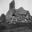
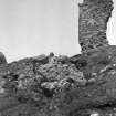
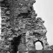
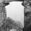
The buildings are arranged in a manner usual on a promontory site. The principal structure, which has been a substantial oblong block of 15th century date, about 82 feet in length and 30 feet in breadth, lies athwart the site fronting the ditch, and from the buildings screen walls return, closely following the sinuosities of the cliff edge, and enclose an area, irregular in shape, of about 800 square yards; the interior level of the enclosure is very irregular and there are indications of vaulted substructures, in places built against the outer walls, over nearly the whole of it. An early photograph familiar in reproduction shows the buildings in much better preservation than at present. The front building is now greatly reduced; the basement has been vaulted and one vaulted chamber still exists at the southern angle. It measures 15 feet 6 inches by 18 feet 1 inch and is partly filled with debris, but can be entered through a broken window in the southern face; the vault rises to about 8 feet above the present floor. There is an aumbry at the northern end and a fireplace with flue through the vaulting at the south-east corner. There has been, apparently, a second vaulted chamber adjoining, and beyond this to the east the principal entrance, which has passed through the block to the courtyard. A tall 17th century tower, measuring 16½ by 13½ feet, has been added to the main block, with which it communicated, and projects within the courtyard; it contained a vaulted storey at the level of the upper floor of the main block, an upper storey and an attic floor, but there may be an undercroft under the debris and not now accessible. In the vaulted storey a scale and platt stair has been inserted at a later time. The roof was gabled and the north gable remains, the skewput having the usual cavetto. A window, 4 feet by 2 feet 6 inches, with a pointed arch head lit the vaulted chamber. Beyond the tower in the north-west corner of the enclosure is a later house 34 feet in length and 15 feet in breadth within walls 2 feet 2 inches thick. The west wall is built against the wall of enceinte, while the north gable is built upon the wall. There is an opening through both walls on the west side, 3 feet wide, and to the south of it a silled opening in the east wall with a wider gap. There are joist holes in both lateral walls, 7 feet inches from ground level.
The walls of the enceinte vary considerably in thickness. The west face, which is throughout original, has a thickness of 4 feet 4 inches. At the north-west corner is a corbelled projection about 10 feet from the ground constructed in thin continuous slabs of stone. The projection still rises to some 4 or 5 feet in height and is some 4½ feet wide on each side of the angle, while the lower slabs are continued as a string-course along the northern face of the wall as far as a re-entrant angle. From this angle the wall returns as a flat receding angle and near the apex is a postern or sea-gate which opens below the level of the present interior, as the ground outside is but a narrow ledge, which drops to the sea-level in perpendicular cliffs; access here could be got only by some artificial means. The north-eastern angle of the enclosure is a projecting bastion circular on the lower part, the upper part being angular. The eastern angle of the main block is also an angular bastion. The building throughout is in the local basaltic rubble, some of which is much weather worn. It is in a very bad condition and much of it has fallen within recent years. To the south of the castle is a natural oval mound about 3 feet high with a very slight rampart or rim round the top known as Cnoca Mhoid ("Moot Hill ").
HISTORICAL NOTE. The earliest specific mention of Duntulm is in the Description of the Isles appended to Skene's Celtic Scotland (vol. iii. p. 432), which he dates between 1577 and 1595 : "Thair was ane castell in Trouternes callit Duncolmen (c was frequently confused with t), quhairof the wallis standis yet." The next is in the obligation imposed upon Sir Donald Macdonald of Sleat by the Privy Council in 1617: "that the said Sir Donald sall makhis residence and duelling at Duntillum, and, yf he has not a sufficient comelie house ansuerableto his estate alreddy thair that he sall withall convenient diligence prepair materiallis andcaus build ane civile and comelie house, and, yf his hous be decayit, that he sall repair and mend the same."
The history of Duntulm is bound up with that of the Trotternish lands, which, after the forfeiture of the Macdonald, Lords of the Isles, became a royal baillary. In 1498 Alexander Macleod of Dunvegan was granted the office of baillie. Later, however, in the same month and year the same office was conferred upon Torquil Macleod of Lewis with the lands of "Duntullyn," i.e. Duntulm (1). But in 1510 Gilleasbuig Dubh, son of Hugh Macdonald ofSleat, was baillie (2), and from this time the Sleat family maintained a claim on these lands as rivals of the Dunvegan Macleods. In 1549 Trotternish is said by Dean Monro to belong to Donald (Macdonald) Gormson of Sleat. Finally, during the closing years of the 16th century a series of royal charters to Donald Gorm Mor, culminating in a confirmation of 1618 to his successor, Donald Gorm Og ("the younger "), settled the Trotternish lands upon the Sleat family, who were to compensate the Dunvegan Macleods with a sum of money. Thereafter Sir Donald was to make his dwelling at Duntulm, as expressed above. The ancient seat of the Sleat Macdonalds or Clan Huisdein had been Dun Scaich (NG51SE 1). In all the various official documents applying to these Trotternish lands there is no reference to the castle.
RCAHMS 1928, visited 4 June 1921.
OS map: Skye iv.
(1) R.M.S., s.a., Nos. 2420, 2424 ; (2) Reg. Sec. Sig., in Origines Parochiales, ii., part 1, p. 351.