Following the launch of trove.scot in February 2025 we are now planning the retiral of some of our webservices. Canmore will be switched off on 24th June 2025. Information about the closure can be found on the HES website: Retiral of HES web services | Historic Environment Scotland
Field Visit


Date 13 June 1921
Event ID 1104623
Category Recording
Type Field Visit
Permalink http://canmore.org.uk/event/1104623
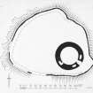
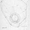
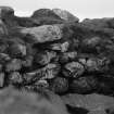
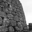
Dun Hallin, Hallin, Vaternish.
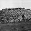
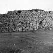
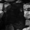
On a small plateau on the hill above, and about 500 yards north-east of the township of Hallin, at an elevation of some 450 feet above sea level, is Dun Hallin, a broch much reduced in height. It stands near the summit of a col in the hilly ridge which runs down the Vaternish peninsula, and so not only overlooks Loch Dunvegan, but gives a prospect of Loch Snizort. The broch (Fig. 206) occupies the south-eastern end of the plateau, and round the edge of the rocky scarp, some 20 feet high, which borders it, are the traces of an outer stone wall forming an outer court, which extends at most from 65 to 85 feet on north-north-west to west from the wall of the main structure, and diminishes to 8 feet or so on the east and south. The wall of the broch is much better preserved than in the great majority of these structures and as usual shows a batter on the outside. On the north and west it shows a height of from 10 feet 6 inches to 12 feet 6 inches of good sound drystone building. At the other parts it is lower, especially on the east, where only one or two courses of building appear above several feet of debris. Inside is a considerable accumulation of rubbish, the wall standing an average height of 4 feet above it. The building is circular with an internal diameter of 36 feet, and the wall is from 9 feet 9 inches to 11 feet thick. The entrance has been on the south-east, but it is too broken down for measurement. On either side of it in the thickness of the wall is an oval cell, the one to the north measuring 9 feet 6 inches in length and 4 feet 9 inches in breadth, while the other, which is more dilapidated, is 9 feet in length above debris. Their entrances are not visible. The gallery in the interior of the wall can be traced on the south-west.
RCAHMS 1928, visited 13 June 1921.
OS map: Skye ix.