Field Visit


Date 17 May 1915
Event ID 1104388
Category Recording
Type Field Visit
Permalink http://canmore.org.uk/event/1104388
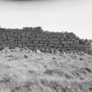
Dun, Rudh an Dunain.
On the seashore, about ½ mile east of Rudh an Dunain, the promontory at the extremity of the peninsula between Loch Brittle and Soay Sound, looking out to the island of Rum, is an elevated rocky plateau with precipitous sides rising over 50 feet in height above the sea on its southern extremity, and about 15 feet above a narrow neck on the landward side by which access to the summit is obtained. The extreme southern projection of the plateau is occupied by the remains of a dun, of which only a portion of the wall on the landward side remains. Though broken down at the ends and somewhat reduced in height, it is one of the best preserved examples of this class of defence in Skye. Any parapet which may have been erected round the edge of the cliff has disappeared, possibly with the erosion of the rock. The remaining wall is a fine specimen of drystone building and contains a number of interesting features (Fig. 296). It crosses the plateau in a convex curve towards the land, and is built of fine large blocks of stone laid in courses with a considerable inward batter on the outer side; on the inside the lower courses for a height of about 3 feet project about 9inches from the face of the wall above, forming what may be called a low scarcement. At the foundation the wall is about 12 feet thick and at the highest part 10 feet. The inner face for about half its length stands some 5 feet in height, and the outer face for the greater part reaches a height of 8 feet 6 inches ; in the centre however a short section measures 11 feet 3 inches in height above more than 1 foot of debris. The entrance, though much broken down, is clearly defined. It is placed about 12 feet from the northern end of the wall and measures 3 feet 1 inch in width at the outside. On either side of the entrance passage, some 3 feet 9 inches from the outside, is a door check 1 foot deep. The wall on the right side of the entrance, though almost reduced to the foundation, shows a width of 12 feet 3 inches. A large slab lying among the fallen stones in the passage, measuring 4 feet 6 inches in length, 2 feet 10 inches in breadth, and 11 inches in thickness, has probably been a lintel stone. A short distance south of the inside of the main entrance is a doorway leading into a narrow gallery built in the thickness of the wall. The doorway narrows towards the inside and about halfway in measures 2 feet 10 inches in width; one of its lintels remains in situ. The gallery in the wall is filled with stones, but at one part measures some 2 feet 10 inches in width, the outer wall being 3 feet 3 inches thick and the inner wall 3 feet 5 inches. To the south the outer wall at one part is 4 feet 9 inches thick. As the latter piece of building stands 4 feet higher than the top of the lintel over the door of the gallery, there seems to have been an upper gallery.
The interior of the dun is of small area and very irregular on plan, and measures about 80 feet across from cliff to cliff behind the wall, but towards the south contracts to a width of some 47 feet. From the inside of the wall to the southern edge of the precipice is about 36 feet. There is evidence of internal buildings within the dun but the shape of these is indeterminate.
RCAHMS 1928, visited 17 May 1915.
OS map: Skye xlix.