Following the launch of trove.scot in February 2025 we are now planning the retiral of some of our webservices. Canmore will be switched off on 24th June 2025. Information about the closure can be found on the HES website: Retiral of HES web services | Historic Environment Scotland
Field Visit


Date 22 April 1925
Event ID 1099288
Category Recording
Type Field Visit
Permalink http://canmore.org.uk/event/1099288
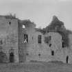
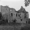
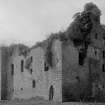
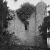
Tulliallan Castle.
This castle is situated on the left bank of the River Forth, half a mile north-east of the river and three quarters of a mile north-west of Kincardine. Although a ruin, it is of special interest, as it has features of arrangement and detail unique in Scottish architecture. In places the site is marshy and unsuitable for heavy building, but in the north-east corner there is an outcrop of rock, nowhere rising higher than 10 feet, and on this the castle is erected. It stands within an enclosure, roughly D-shaped and girt with a broad ditch having a rampart outside of it, the chord of the arc being on the north.
OUTWORKS. Only here and there is the rampart traceable, and the western end of the straight part of the ditch is now difficult to distinguish. The enclosure is entered from thes outh. The present entrance is possibly modern and has apparently replaced an original entrance, the position of which is probably marked by a small re-entrant in the arc, 50 yards farther west. Between this latter point and the northwest angle the ditch is only 13 feet in breadth. Elsewhere it has an average breadth of 30 feet. The ground in the north-east corner is uneven and may conceal the foundations of an outbuilding. Close at hand, but within the ditch, is a fragment of masonry, which may perhaps represent the remains of a conduit or sluice.
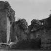
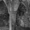
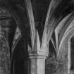
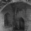
THE BUILDING. The castle is not wholly of one time, and the date and extent of the earliest work in it are in some doubt. It consists of an oblong main block, facing south and running roughly east and west, three-storeyed at one end and four-storeyed at the other, while two wings which have obviously been added to it project from its northern wall in alignment with the gables. At its south-western angle is a tower which projects only slightly on the south, but develops into a semi-octagon on the west. This contains the principal staircase. A semi-hexagon in which there is a service stair, is placed midway along the western wall, masking what may once have been the northwest corner. The ground floor of the main block, with the lower part of the south-west tower and of the two staircases, is not unlike 14th-century architecture. The general plan, however, is characteristic of castles erected a century later, while the upper storeys of the parts just mentioned, in so far as they are original, can be definitely ascribed to the 15th century. The wings are apparently additions, that on the west being a modification introduced when the ground floor of the main block was actually under construction, while that on the east cannot be much later.
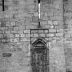
There are two entrances on the south, the principal one in the south-west tower, and the other at the east end of the main block. The former was protected by a portcullis and a barred door, while a mound in front of it may be the foundations of a detached structure on which the outer end of a drawbridge rested when lowered. No ditch can be traced. The gateway, however, is rebated to receive the drawbridge when raised and above is a rainure for the cable or chain. The entrance at the east end, which opens directly into what must have been the old hall, had also a drawbridge, as well as two doors with bars, while in addition there seems to have been a movable shutter sliding in an opening formed in the soffit between the doors. A third entrance at the north-west corner gives admission from the west wing, but was apparently designed to be external as it had two barred doors. This points clearly to a change of plan. From the mound in front of the main entrance a retaining wall runs along the western side of the castle, to support a terrace overlooking what was probably the garden.
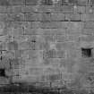
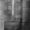
The masonry is of ashlar, the courses averagingII inches, and is mainly cubical but with acertain number of stretchers up to zt and 3 feetin length. The walls, which are 6 feet thick, arebuilt with an outer and an inner casing, theheaders on each having a depth of 9 or 10inches. At the base they have . a batter of ztdegrees, which extends to a height of 9t feeton the front, but is lower elsewhere.
[see RCAHMS 1933, 275-280, for a full architectural description]
HISTORICAL NOTE. In 1304 Edward I ,was ordering his sheriff of Clackmannan to strengthen the walls of "Tolyalwyn” (1). The lands of Tulliallan with the "fortalice" or " forslete of that ilk" were granted in 1410 by Archibald, Earl of Douglas to Sir John Edminstone (2). The Edminstone line ended in two daughters, and, in the spring of 1485-6, Elizabeth Edminstone, wife of Patrick Blackadder, exchanged with her sister certain lands in Banff for the latter's share of the lands of Tulliallan (3). Thereafter the whole lands were conferred upon John Blackadder, the son (4), and continued with this family till the beginning of the 17th century; after 1605 they are found in the hands of Sir George Bruce of Carnock.
In 1619 five men were under trial for the incarceration of another in the "pitt of Tullieallane, quhair, throw want of intertenement, he famischet and deit of hunger" (5).
RCAHMS 1933, visited 22 April 1925.
(1) Bain's Calendar of Docts., ii, No. 1514. (2) The Douglas Book, Sir William Fraser, II, pp. 402, 406. (3) Reg. Mag. Sig., s.a., No. 1644. (4) Ibid., No. 1707. (5) Pitcairn's Criminal Trials, III, p. 479. Cf. also Cast. and Dom. Arch., I, p. 550.