Field Visit


Date 12 June 1925
Event ID 1098852
Category Recording
Type Field Visit
Permalink http://canmore.org.uk/event/1098852
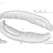
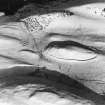
Fort, " Maiden Castle," Bracks, Lomond Hills.
A little over half a mile to the southwest of the Tyndall Bruce Monument, at an elevation of 900 feet above sea-level, a grassy hillock known as "Maiden Castle" rises steeply from amidst the rougher ground between two low spurs of the Lomond Hills (SC 1123653). The knoll is elliptical in outline, with the major axis almost due east and west, and the some somewhat flattened summit measures roughly 461 feet in length by 114 feet in greatest width. Apart from a single earthen rampart with a ditch on the inner side, which lies along the base of the hillock on the north and south sides, it shows little evidence of adaptation as a defensive site. There are, however, some slight indications of terracing about midway up the steeply sloping scarps at the west-south-west and east-north-east. Even so, the knoll, as a defensive site, could have derived little advantage from its position unless, as seems probable it was at one time mostly surrounded by water or marshy ground. Towards the south-east the ditch shows a well-defined traverse 18 feet in breadth. Rampart and ditch both die out to the west on either side of an approach, which has an average width of 16 feet and which curves up the slope of the knoll in a north-easterly direction. They are broken again at the opposite end by an entrance 20 feet wide, opening from a natural ridge which gives easy access from the east.
RCAHMS 1933, visited 12 June 1925.