Scheduled Maintenance
Please be advised that this website will undergo scheduled maintenance on the following dates: •
Tuesday 3rd December 11:00-15:00
During these times, some services may be temporarily unavailable. We apologise for any inconvenience this may cause.
Field Visit


Date 19 May 1926
Event ID 1098650
Category Recording
Type Field Visit
Permalink http://canmore.org.uk/event/1098650
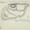
Fort, Norman's Law.
Occupying the summit of the hill at an elevation of 936 feet above sea-level, this fort, despite its great size, does not exhibit the complexity or constructive skill that is so conspicuously in evidence on other large fortified sites in the county, such as Clatchard Craig (NO21NW 18), and the East Lomond (NO20NW 20). It is nevertheless remarkable for the extent and strength of its walled defences, which have been well adapted to the broken and rugged character of the hill-side. The name "Dun-more" or "the great fort," frequently applied to it, is well deserved. In common with many other prehistoric structures in the county, it has been much destroyed and the walls are scattered to the foundations, except for a mere fragment, showing only two courses, which remains at the north-east corner. The enclosure, which is kidney-shaped, lies with its major axis almost due east and west, and measures approximately 180 by 100 feet. It has been protected by a massive wall, varying in thickness from an average of 9 or 10 feet to a maximum of 16 feet at the entrance, which is at the north-east corner and is 10 feet wide. The ground within is broken and uneven, inclining sharply downwards to the south and east, where there is a somewhat sheltered hollow, covered with indefinite remains and debris, which according to Small was the position of a well (1).
Reference to the plan will show that, except on the north, where its wall follows the natural contour of a steep and rocky scarp rising abruptly from lands now under cultivation, the main fort is completely surrounded by a second enclosure, of which it might almost be regarded as the citadel. Like the main fort itself, this second enclosure is entered close to its northeast corner, where the continuity of the surrounding wall is broken by a gap 15 feet wide. Adjoining it on the east is a third and slightly larger enclosure, which can best be described as an annexe. It is entered at the south-west corner and is without artificial protection on the north except at the eastern extremity, where there is a short return of the wall that bounds it on the east and south. Outside of the whole is yet another wall, which seems to start near the north-east corner of the plateau, but stops abruptly after making a rapid approach to the wall of the annexe. Resuming its course 150 feet farther on, it sweeps southwards, westwards (with a gap of 20 feet for entrance), and finally northwards until it is lost against the face of a rocky hillock. The enclosure which it. forms is thus incomplete, but it is considerably larger than the second and third taken together. It should be added that all of the walls, except those of the main fort, are in such a ruinous condition that it is impossible to determine their details with precision. It cannot even be said with any confidence that they were contemporaneous.
RCAHMS 1933, visited 19 May 1926.
Cf. Interesting Roman Antiquities of Fife, p.231.