Following the launch of trove.scot in February 2025 we are now planning the retiral of some of our webservices. Canmore will be switched off on 24th June 2025. Information about the closure can be found on the HES website: Retiral of HES web services | Historic Environment Scotland
Antonine Wall - preparation of maps for the World Heritage Site nomination document


Date 2006 - 2007
Event ID 1091105
Category Project
Type Project
Permalink http://canmore.org.uk/event/1091105
In 2007 Historic Scotland prepared a nomination document for the proposed extension of the Frontiers of the Roman Empire World Heritage Site through the addition of the Antonine Wall. The nomination document, ISBN 13-978-904966-38-8, comprised two volumes along with a management plan. The maps for the document were prepared by RCAHMS. Those included in Volume II are detailed below:
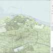
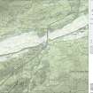
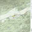
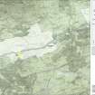
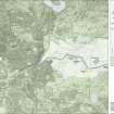
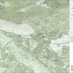
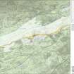
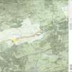
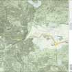
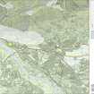
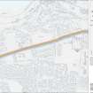
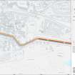
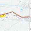
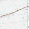
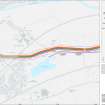
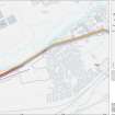
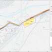
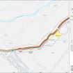
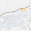
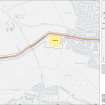
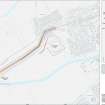
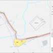
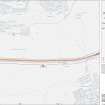
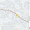
I - The position of the Antonine Wall in the Roman Empire, II - The location of the Antonine Wall and Hadrian's Wall in north Britain, III.1 - The Antonine Wall and accompanying features and local authority Council areas, III.2 - The Antonine Wall and accompanying features, the scheduled areas, the buffer zones and local authority Council areas, IV - Index map to the 1:25000 maps, IV.I 1-8 - Series 1: Maps of the Antonine Wall at a scale of 1:25000 showing the proposed World Heritage Site, known forts and fortlets, camps, other features and the buffer zones, IV.I 1-8 - Series 2: Maps of the Antonine Wall at a scale of 1:25000 showing the proposed World Heritage Site, known forts and fortlets, camps, other features, the scheduled areas and the buffer zones, V - Index map to the 1:5000 maps, V. 1-39 - Maps of the Antonine Wall and its known features at a scale of 1:5000 showing the scheduled areas and the proposed World Heritage Site.
Editorial Notes from the document in which all maps were published:
The maps in this booklet are based on information derived from various scales of Ordnance Survey material with the permission of the Ordnance Survey on behalf of the Controller of Her Majesty’s Stationery Office © Crown Copyright. Unauthorised reproduction infringes Crown copyright and may lead to prosecution or civil proceedings. RCAHMS Licence number 00020548 2006.
All maps © Crown Copyright: RCAHMS and Historic Scotland.
The depiction of the Wall is based on the most recent comprehensive field study of the monument undertaken by the former Ordnance Survey archaeological branch in 1980. This has been supplemented and enhanced through information collated during more recent field survey, excavation and aerial photographic transcription by RCAHMS.
A standardised depiction for the Wall has been adopted on all the maps. On the 1:25,000 and 1:5,000 maps (IV and V), the component features of the Wall (the rampart, ditch and upcast mound) have been depicted to standard overall widths based on the Ordnance Survey mapping though even at this scale it has not been possible to illustrate all the nuances in width. The
widths of these features on the maps should therefore be regarded as symbolic.
The proposed World Heritage Site has been defined in the following way. Along the line of the Wall the southern boundary of the proposed World Heritage Site has been placed 5 m to the south of the rampart and then projected 50 m to the north of this line creating a 50 m corridor. This corridor includes the three main linear features together with other elements that are likely to lie immediately beyond the known archaeology. This corridor is widened where necessary to include forts, fortlets, the Military Way and other elements of the frontier which are attached to the linear barrier. Camps, usually placed at some distance from the Wall,
are defined separately.
Where the Wall and its associated structures such as forts and camps are protected though scheduling, the proposed World Heritage Site line has been placed around the perimeter of the scheduled area, except where the scheduling relates to a monument of a different period.
Where the scheduled area and the proposed World Heritage Site line coincide, the proposed World Heritage Site line has been offset to enable both to be visually depicted on the maps.
The buffer zones are depicted on the 1:25,000 maps (IV) but not the detailed 1:5,000 maps (V). Destroyed areas of Wall are not included within the proposed World Heritage Site but are protected by the buffer zones. For illustrative purposes, where the Wall has been destroyed, this part of the buffer zone is depicted on the 1:5,000 maps (V) as a dashed line the same width as the proposed World Heritage Site.
The 1:5,000 maps (V) and the 1:25,000 maps (IV) include details of all known archaeological features associated with the Antonine Wall. The maps are numbered sequentially from East to West in line with archaeological convention for the Wall. Features such as forts are depicted with a coloured line defining their perimeter. The proposed World Heritage Site line lies 5 m from this perimeter but may appear further on the maps due to mapping conventions.