Pricing Change
New pricing for orders of material from this site will come into place shortly. Charges for supply of digital images, digitisation on demand, prints and licensing will be altered.
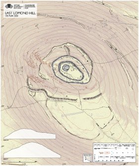
HES Plan of East Lomond Hill
WP 007292
Description HES Plan of East Lomond Hill
Date 17/11/2020
Collection Historic Environment Scotland
Catalogue Number WP 007292
Category Digital Files (Non-image)
Scope and Content Layered PDF. The archaeological plan of East Lomond Hill was developed using a variety of HES sources that included a 3D image-based model, oblique aerial photographs and GNSS survey data. In addition, vertical aerial photographs, historic maps and documentary sources were consulted. The plan has been archived as an SVG file (Collection Item: GV008341) and a derived raster image (SC2111392 ), with a layered PDF available to download, (WP007292). Accompanying site descriptions have been published on Canmore, with the numbering on the plan referred to in the text relating to the fort (Canmore ID: 29881).
Permalink http://canmore.org.uk/collection/2111393
File Format (PDF) Adobe Acrobat document
Attribution: © Copyright: HES.
Licence Type: Internally Generated
You may: copy, display, store and make derivative works [eg documents] solely for licensed personal use at home or solely for licensed educational institution use by staff and students on a secure intranet.
Under these conditions: Display Attribution, No Commercial Use or Sale, No Public Distribution [eg by hand, email, web]


