Pricing Change
New pricing for orders of material from this site will come into place shortly. Charges for supply of digital images, digitisation on demand, prints and licensing will be altered.
Stack Islands, Eilean Leathan, Weaver's Castle
Tower House (Medieval)
Site Name Stack Islands, Eilean Leathan, Weaver's Castle
Classification Tower House (Medieval)
Alternative Name(s) Cristal A Bhrebider; Caisteal An Reubadair; Na Stachan Dubha; Eriskay
Canmore ID 9763
Site Number NF70NE 1
NGR NF 7859 0717
Datum OSGB36 - NGR
Permalink http://canmore.org.uk/site/9763
- Council Western Isles
- Parish South Uist
- Former Region Western Isles Islands Area
- Former District Western Isles
- Former County Inverness-shire
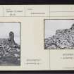
Weaver's Castle (Caisteal a' Bhreabadair) Mortared rubble ruin of a tower of uncertain date, once a stronghold of the MacNeils. Later it was the home of the notorious pirate wrecker Breabadair Stache (weaver being a corruption of riever). He and most of his family were eventually slain by soldiers.
Taken from "Western Seaboard: An Illustrated Architectural Guide", by Mary Miers, 2008. Published by the Rutland Press http://www.rias.org.uk
NF70NE 1 7859 0717.
(NF 7859 0717) Weaver's Castle (NR) (Ruin)
OS 6" map, Inverness-shire, 2nd ed., (1904)
Weaver's Castle or Caistal a Bhrebider is situated on Eilean Leathan, the largest and most southerly of the Stack Islands off the south coast of Eriskay. It is a rectangular tower of rubble in lime mortar measuring 12 1/2ft E-W by 9 3/4ft N-S within walls 4 1/4 to 4 1/2ft thick. In 1924, the NE corner stood to 15 1/2ft and the other walls were 4ft high.
RCAHMS 1928; New Statistical Account (NSA, Rev R Maclean) 1845.
Weaver's Castle is generally as described above.
Surveyed at 1:10560.
About 30.0m. east of the castle are the stone footings of two shieling-like structures within an associated circular enclosure.
Visited by OS (E G C) 22 May 1965.
Field Visit (8 August 1924)
Weaver's Castle, Stack Islands.
Eilean Leathan, the largest and most southerly of the Stack Islands off the south coast of Eriskay, is shaped roughly like an hour-glass, the larger northern part being low, while the southern portion rises steeply to an altitude of 144 feet and is defined by a deep gully terminating at each end in a narrow inlet, the eastern forming a natural harbour. On the steep slope above the landing are remains of walling, evidently the seating of a crane or hoist. On the summit is a fragment of a tiny rectangular tower built of rubble in lime mortar. The building measures 12 ¼ feet from east to west, by 9 ¾ feet from north to south, within walls 4 ¼ to 4 ½ feet in thickness. The north-east corner stands to a height of 15 ½ feet; the other walls are 4 feet above their foundation.
RCAHMS 1928, visited 8 August 1924.
OS map: Barra, lxiii.


