
Broughwhin


Cairn (Period Unassigned), Cist (Period Unassigned), Quarry(S) (Period Unassigned), Stone Row (Neolithic) - (Bronze Age)
Site Name Broughwhin
Classification Cairn (Period Unassigned), Cist (Period Unassigned), Quarry(S) (Period Unassigned), Stone Row (Neolithic) - (Bronze Age)
Canmore ID 9017
Site Number ND34SW 19
NGR ND 31254 40965
Datum OSGB36 - NGR
Permalink http://canmore.org.uk/site/9017


- Council Highland
- Parish Wick
- Former Region Highland
- Former District Caithness
- Former County Caithness
ND34SW 19 31254 40965.
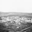
Cairn, 18ft in diameter, with short cist, and four stone rows radiating to the SW. Only 6 or 7 stones remain: the furthest is about 110ft from the cairn. They are thin slabs, up to 2ft in height, set with their broad faces looking across the rows.
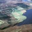
These features lie at the south end of the ridge between Groat's Loch and Broughwhin.
RCAHMS 1911.
The cairn (with short cist exposed) and stone rows are as described by the Commission and are located at ND 3125 4097.
Surveyed at 1/2500.
Visited by OS (N K B) 27 April 1967.
(NC 3124 4095) Cairn & Stone Rows (NR)
OS 1:10,000 map, (1976)
This cairn (YARROWS04 005; ND 31239 40951) is situated on the leading edge of a SE-facing terrace in heather moorland some 180m NW of Groat's Loch. It measures about 7m in diameter by 0.4m in height and is composed of a mass of small boulders. A cist has been exposed at the centre and measures 1.5m from E to W by 0.73m transversely and 0.6m in depth. The E end and both sides are constructed of single slabs, but the W end is missing, though it may be the diamond-shaped slab that presently lies on top of the cairn on the S. The original capstone may be the slab measuring at least 1.1m across, that leans against the E side of the cairn. Beneath it there is another, smaller, slab.
The remains of the stone rows (YARROWS04 006) are scattered to the SW, NW and N of the cairn respectively: those immediately to the SW comprise two small slabs standing 14m apart; three slabs 50m NW form another row some 19m in length from NE to SW; and 100m N two small slabs stand 5.7m apart.
Some minor quarrying (YARROWS04 575-7), which is marked by a line of shallow excavations dug into the SE-facing slope, extends from a point 8m SE of the cairn and runs for a distance of about 27m to the SSW.
(YARROWS04 005, 006, 575-7)
Visited by RCAHMS (JRS) 24 May 2004

