
Torwoodlee


Linear Earthwork (Period Unassigned)
Site Name Torwoodlee
Classification Linear Earthwork (Period Unassigned)
Canmore ID 88100
Site Number NT43NE 49
NGR NT 4702 3795
NGR Description From NT 4702 3787 to NT 4662 3856
Datum OSGB36 - NGR
Permalink http://canmore.org.uk/site/88100


- Council Scottish Borders, The
- Parish Galashiels
- Former Region Borders
- Former District Ettrick And Lauderdale
- Former County Selkirkshire
NT43NE 49 from 4702 3787 to 4662 3856. LIN 11.
Formerly LIN 528.
For southern part of LIN 11 see NT43NE 50, NT43SE 38 and NT43SE 39
Earthwork [NR]
OS 1:10000 map, 1983
RCAHMS 1957 is unsure whether this site is suppose to be linked with NT43NE 50, NT43SE 38 & 39.
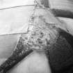
The policies of Torwoodlee with their adjacent plantations and fields, occupy the tip of an eastward extension on Mains Hill (NT 4545 3795) round which the Gala Water runs in an irregular loop. The earthwork now to be described crosses the base of this loop, from NT 4702 3787 to NT 4662 3856, but as neither of its ends rests on the bank of the river it cannot be safely regarded simply as the western boundary of the area so enclosed, and nothing more. Indeed, it is now commonly regarded, whether rightly or wrongly, as continuous with the works described under NT43NE 50 and NT43SE 38 and NT43SE 39 thus forming part of the work named The Catrail or Pictswork Ditch on the 1st edition of the OS 6-inch maps (Selkirkshire, 1863) (Lynn 1898).
The OS 1st edition map marks the former line of the work as striking NNW from NT 4702 3787 to NT 4695 3802. Actually several hollow tracks of an old road lead up from the left bank of the Red Burn at this point (NT 4702 3787), and among these, near the burn, there is what seems to be a fragment of a bank 15 yds in length (NT 4702 3787 to NT 4702 3788). From here (NT 4702 3788) up to the avenue nothing positive can be seen, but across the avenue a ditch with a greatly spread bank to the E of it appears and can be followed for 60 yds to the crest of a slope (NT 4702 3788 to NT 4695 3802). However, as the work approaches the old Edinburgh road the record becomes confused by spoil tipped off the road and piled on top of the bank, and by the cutting through the resulting mound of a drainage ditch just E of the bank's original position. Still farther up this slope another section of the ditch and bank, 30 yds in length, can be seen on the OS line, the bank still being E of the ditch (NT 4681 3806 to NT 4680 3808.
About 130 yds WNW from NT 4695 3802, across a field, the earthwork reappears on a different alignment, some 60 yds SSE of a small reservoir, in a felled plantation. The fragment SE of the farm-road is 26 yds in length, and consists of a ditch with a mound on its E side; while above the reservoir a section at least 100 yds in length can be traced running NNW along another strip of plantation (NT 4675 3815 to NT 4666 3827). No doubt the OS indication, which carries it to NT 4666 3827, beyond what is shown as the head of the strip, was originally correct, but today no signs can be seen at the upper end or in the field beyond, now also planted in this part. The whole of this section is too much dilapidated for measurement.
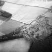
From NT 4666 3827, the OS 1st edition map marks the line as having mounted the hillside obliquely to the plantation on the ridge SW of the fort and broch (NT43NE 2). Nothing can be seen here today, but the line may be approximately correct as an earthwork of similar character begins about the centre of this plantation 230 yds SW of the broch (NT 4632 3835). From the point of its reappearance the work - which still has the bank on the E side of the ditch, on the inner side of the loop - curves N and NNE for 30 yds to the N corner of the plantation and thence follows the line of the stone dyke separating two fields, one now planted with trees, for a further 70 yds towards the NE. Some 23 yds short of the corner, the bank changes over from the inner to the outer side of the ditch, maintaining, however, the downhill position in its relation to the latter. A gap of about the same breadth follows across a field, but from the corner of the next stone dyke the ditch can again be seen running along the NW side of the dyke, which stands on its lip. Some 40 yds farther on again the work enters a felled plantation, through which it runs on a course which gradually swings to the E and flanks the N side of the fort at a distance of about 40 yds. It is here much better preserved, the ditch being 11ft to 14ft wide, the bank, which is still on the N or downhill side, being spread to a width of from 14ft to 17ft and standing up to 2ft 6 ins above the ditch bottom (NT 4632 3835 to NT 4662 3856). The bank contains a good deal of broken stone in addition to earth.
The work has not been preserved beyond the E boundary-wall of the felled plantation (NT 4662 3857), but some slight indications suggest that it may here have turned downhill. In its final 40 yds it swings very appreciably N of E and where the broken end of the bank appears on the E side of the wall, under its foundations, this tendency seems to be increasing. In fact, just below this point a slight hollow which may represent the filled-up ditch can be seen running N, downhill just E of the wall; while a stretch of the wall between 50 yds and 30 yds above the old Edinburgh road seems to be founded on an accumulation of stones resembling the spread bank of an earthwork. It is thus quite possible that the earthwork may have followed this line as far as the Gala Water, (on one of his plans, Lynn (1898) marks two fragments of the earthwork at the point here indicated, but this must not be taken as corroborative evidence as the remains in question are those of a terraced roadway) or have ended somewhere below the Edinburgh road where the ground is steep and rough, the plantation wall, if so, having been built on the ruins of its bank. Against this suggestion must be set a point mentioned by the late Mr J L Pringle of Torwoodlee, namely that a wide, deep ditch had been found descending the shoulder of the hill ESE from the fort on the summit (NT43NE 2) and reaching the avenue just opposite the site of the fort by the kitchen garden (NT43NE 7). Nothing, however, that resembles the rest of the 'Picts' Work Ditch' can be seen along this line at present. In either case the peculiar course of the earthwork as described above, with its detour to the W of the fort (NT43NE 2) between NT 466 383 and NT 466 386, seems to call for explanation. If, as it is natural to suppose, the fort was ruinous and uninhabited at the time when the earthwork was built, it is surprising that its builders did not run their line right through the fort, incorporating it into their work. To have done so would have saved some 570 yds of ditch-and-bank construction, at a loss of less than 15 acres of ground, much of which was already encumbered with the ruins of the fort. It is therefore tempting to suggest that the site of the fort may have been in use for some purpose, as a consequence of which the adjoining ground to the west had to be enclosed by the boundary of the region as a whole. Alternatively, it is possible to maintain that the 'loop' to the W of the fort (NT 4632 3835 to NT 4662 3856) is not really a part of the linear earthwork at all, but of an outer fort-rampart of which the E arc has vanished. On this showing the end of the earthwork would have rested on the S arc of this outer rampart somewhere near NT 466 383; while, if another section started on the N arc at NT 466 386, to run on to the Gala Water in the manner suggested above, the fort would in fact have been utilised as part of the boundary, accounting for length of some 230 yds. However, the fact that the bank of the enclosing work moves over from the 'inner' to the 'outer' lip of the ditch on the W of the fort, where the direction of the slope alters, argues strongly against this theory; to maintain the bank on the downhill side of the ditch is common practice in the construction of boundary earthworks, but would be futile in a military context. Again, the earthwork's tendency, mentioned above, to swing away from the fort in its terminal surviving section would not be natural in the case of an outer rampart.
Visited by RCAHMS 19 October and 26 November 1946, 9 December 1947.
F Lynn 1898; RCAHMS 1957.
These stretches of earthworks remain generally as described by RCAHMS.
NT 4646 3882 - NT 4672 3869: The two sections on OS 25-inch map (1900), marked 'Catrail' (NR) are rutted terraceways (c.6m broad), no doubt denoting the course of an old road, either in association with the old forestry plantation in which they are located, or a link in a possible old road extending from NT 4646 3882 to NT 4688 3867, and possibly beyond, along an avenue of trees to the road at Torwoodlee golf course.
NT 4662 3856 - NT 4644 3852: Within a young plantation north of Torwoodlee fort, a well-defined section of bank and ditch, the latter being on the S, or uphill side.
NT 4644 3852 - NT 4641 3850: Ditch traceable as shallow depression on side of dyke. Bank continues from plantation on E for c.15m.
NT 4641 3850 - NT 4637 3846: No trace across pasture-field.
NT 4637 3846 - NT 4632 3835: Ditch appears in pasture-field for c.10m before entering felled part of an old plantation. Here it is accompanied by a low spread bank on its N side. After crossing a track, the ditch only continues for c.20m, thence it is accompanied by a slight bank on the E side.
NT 4632 3835 - NT 4666 3828: Beyond the track to the edge of the wood there is no trace of the earthwork, nor can it be found on the slopes of the adjacent pasture-field. An area of rig-and-furrow, running N to S, occupies the lower part of the slope.
NT 4666 3828 - NT 4678 3812: The next section of earthwork is found in a plantation S of a farm-track (the Old Edinburgh Road). Here, the bank can only be traced.
Immediately S of the plantation another area of rig-and-furrow is encountered and one rig almost occupies the course of the earthwork, tending to cause confusion.
NT 4679 3808 - NT 4681 3805: Across another farm-track a short stretch of bank c.30m long, with traces of a ditch on the W side, is found running through a felled strip of wood.
NT 4681 3805 - NT 4696 3801: There is no trace of the earthwork across a ploughed field.
NT 4695 3802 - NT 4702 3787: On entering the wooded policies of Torwoodlee, the ditch with bank on the E side is again encountered for a distance of c.48m. After a short break of c.26m the form of earthwork is resumed, the bank becoming much more spread and less high. This is traced for c.94m until a little distance short of the Avenue.
Visited by OS (WDJ) 19 January 1961
In 1480, the ranger of Yarrow got 2000 'vangorum et tribulorum' i.e. spades and forks. These may have been used for making ditches and banks to form the bounds of the stedes in Ettrick Forest, bounds which still seem to be shown on the OS maps. That they were used for planting is doubtful.
M L Anderson 1967

