
Following the launch of trove.scot in February 2025 we are now planning the retiral of some of our webservices. Canmore will be switched off on 24th June 2025. Information about the closure can be found on the HES website: Retiral of HES web services | Historic Environment Scotland
Suttie


Pit(S) (Period Unassigned), Rig And Furrow (Medieval) - (Post Medieval), Ring Ditch (Period Unassigned)
Site Name Suttie
Classification Pit(S) (Period Unassigned), Rig And Furrow (Medieval) - (Post Medieval), Ring Ditch (Period Unassigned)
Alternative Name(s) Wester Fintray
Canmore ID 83674
Site Number NJ81NW 38.03
NGR NJ 8131 1572
Datum OSGB36 - NGR
Permalink http://canmore.org.uk/site/83674


- Council Aberdeenshire
- Parish Fintray
- Former Region Grampian
- Former District Gordon
- Former County Aberdeenshire
NJ81NW 38.03 8131 1572
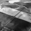
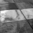
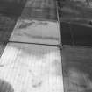
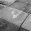
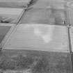
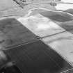
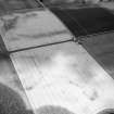
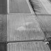
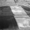
Cropmark of a ring-ditch.
Information from Mrs M Greig (Grampian Regional Council), 24 April 1995.
List of air photographic cover.
NMRS, MS/712/19 and MS/712/21.

