
Pricing Change
New pricing for orders of material from this site will come into place shortly. Charges for supply of digital images, digitisation on demand, prints and licensing will be altered.
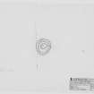
Pullyhour


Henge (Neolithic) - (Bronze Age)
Site Name Pullyhour
Classification Henge (Neolithic) - (Bronze Age)
Canmore ID 8366
Site Number ND15SW 3
NGR ND 1147 5449
Datum OSGB36 - NGR
Permalink http://canmore.org.uk/site/8366


- Council Highland
- Parish Halkirk
- Former Region Highland
- Former District Caithness
- Former County Caithness
ND15SW 3 1147 5449.
(ND 1147 5449) Tumulus (NR)
OS 6" map, Caithness, 2nd ed., (1907)
Some 200 yds W of Pullyhour, on a piece of waste ground, is a circular bank 8 to 9ft thick and about 2ft high, enclosing an area about 43ft in diameter in the centre of which is a flat-topped mound 28ft in diameter and about 6ins to 1ft in height. The whole is overgrown with turf, but it appears to be stony underneath. There is no break in the enclosing bank. Its character is doubtful.
RCAHMS 1911, visited 1910.
Generally as described above except that there is a slight gap in the outer bank on the S side, leading to a causeway across an inner ditch. This appears to be a hengiform enclosure.
Resurveyed at 1:2500.
Visited by OS (E G C) 16 April 1962.
(ND 1147 5449) Enclosure (NR)
OS 6" map, (1963)
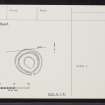
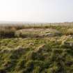
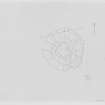
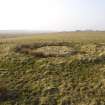
A hengiform earthwork, levelled into a gentle E-facing slope in rough pasture. It comprises a flat and featureless central area, 8.0m in diameter within a silted ditch and outer bank. The latter is 3.0 to 3.5m broad and varies from 0.2 to 0.8m above the bottom of the ditch; there is no trace of any stones protruding through the turf. There is a simple entrance and causeway in the S arc. According to the farmer, no finds have been made; the earthwork appears undisturbed.
Visited by OS (N K B) 19 February 1982
Enclosure, 'Pullyhour'. Diameter:19.4m. Hengiform earthwork with internal ditch and external bank 3.5m wide. The height from base of ditch to top of bank is 1m, while the central platform lies 0.5m above the ditch base. There is a suggestion of a causeway through the bank on the SW axis.
R J Mercer, NMRS MS/828/19, 1995
Excavation (2008)
ND 1147 5449 In the N of Scotland there are a number of earthwork monuments that have been described as ‘henges’ or ‘hengiforms’. They have a number of features in common. All are small circular enclosures with an external bank, a wide internal ditch and a surprisingly small interior. Until recently, few of the sites had been excavated. One example at Loch Migdale, Sutherland, was investigated by Time Team without any result. Another was recorded during road building at Lairg. The first research excavation did not happen until Easter 2008, with the investigation of a well preserved earthwork at Pullyhour, Caithness.
The site was on the side of a valley overlooking the Thurso River, in a position with evidence of Mesolithic activity. The earthwork had a single entrance and a well preserved external bank. It was exactly aligned on the remains of large cairn on the opposite bank of the river. In Caithness, monuments of this kind normally date from the Neolithic period.
The earthwork was built in two phases. The first was a circular enclosure with a broad internal ditch which must have held water. It had been built in open country which was not used for farming. A date from the old land surface shows that it has a terminus post quem of 1620–1450 BC. In its second phase the enclosure was converted to an oval ground plan by widening the ditch on the inside. A small horseshoe-shaped bank was constructed on its inner lip, and the area inside it was cobbled. At the same time the outer bank was enlarged and its inner edge was probably revetted on by a rubble wall. This phase is dated to between 1320–1120 BC. A small post was erected in the centre of the enclosure.
The entrance was very narrow and was flanked by a stone kerb. Just outside it was a pair of posts. One was much larger than the other, and the base of the upright still survived. This was a substantial piece of pine, a species which became extinct in Caithness at the end of the Neolithic period. It has a radiocarbon date of 2580–2340 BC. Its socket had been cut through the secondary bank, so that it could not have been erected before the Middle Bronze Age. Not only had the builders aligned the enclosure on an ancient monument, they raised a massive post which must have been dug out of a bog. Its actual age could not have been known, but they would have been aware that it was a relic of some antiquity. The only artefacts associated with the Bronze Age structure were two flint flakes.
Finally, the monument was decommissioned. The rubble supporting the bank was pushed into the ditch and the
entrance was blocked by a small cairn. The pine post was uprooted and the stones that had held it in place were smashed to pieces and used to cover its socket. There is no archaeological evidence of further activity on the site.
Archive: RCAHMS (intended)
Funder: Reading University. Wood conservation and dating: National Museums Scotland.
Richard Bradley and Hugo Lamdin-Whymark (Reading University), 2008

