
Back Of The Wall


Enclosure(S) (Post Medieval)(Possible), Field Boundary (Post Medieval)
Site Name Back Of The Wall
Classification Enclosure(S) (Post Medieval)(Possible), Field Boundary (Post Medieval)
Alternative Name(s) Glenluce Abbey
Canmore ID 82338
Site Number NX15NE 77
NGR NX 18576 58442
NGR Description Centre
Datum OSGB36 - NGR
Permalink http://canmore.org.uk/site/82338


- Council Dumfries And Galloway
- Parish Old Luce
- Former Region Dumfries And Galloway
- Former District Wigtown
- Former County Wigtownshire
Note (6 June 2022)
The location, classification and period of this site have been reviewed and changed from ENCLOSURE(S) (PERIOD UNASSIGNED).
Aerial Photographic Interpretation (31 March 2022)
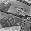
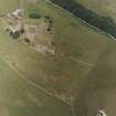
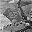
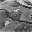
Ditched field boundaries have been recorded as cropmarks on oblique aerial photographs (RCAHMSAP 1992, 1995) on the broad former floodplain to the W of the Water of Luce and S of Glenluce Abbey. The boundaries, which are aligned from N to S and roughly E to W, are likely to be of post-medieval date.
Information from HES Archaeological Survey (D. Cowley) 31 March 2022.

